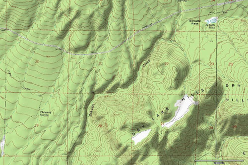
TopoFusion.com
TopoFusion News
Your source for the latest TopoFusion, GPS and Mapping developments.

We’ve released version v3.973 of TopoFusion Pro today. A server change has made previous version of TopoFusion Pro unable to download topo and black/white aerial maps. The problem is intermittent, but has been popping up enough lately that it prompted us to release a new version of the software.


Head over to the Download Page to try TopoFusion out, free of charge.

Registered users refer to your registration email for the download link, or go here to request your code and the download URL.

Full list of changes

For a complete list of changes see the Revision History


click to enlarge

We’ve released version v3.971 of TopoFusion Pro today. A server change has made previous version of TopoFusion Pro unable to download color aerial maps for many states. This release corrects that problem, as well as a minor issue with Topo maps from Terraserver (now named MSRMaps).

The good news is that with this release we have also managed to increase the coverage area for color aerials. TopoFusion now can download maps for all of the lower 48 states (plus Alaska). There are still a few gaps in coverage within a small number of states (see updated coverage map above).


Head over to the Download Page to try TopoFusion out, free of charge.

Registered users refer to your registration email for the download link, or go here to request your code and the download URL.

Full list of changes

For a complete list of changes see the Revision History


Being a small software company, we here at TopoFusion have always prided ourselves on being able to listen to our customers and help grow the program to meet their needs. Many of our most notable features were dreamed up to serve our diverse user base.

The latest revision of TopoFusion Pro is no exception. This version includes a long list of improvements, fixes and tweaks, almost purely by user request. A few examples: UTM grids on color aerials, new aerials for Florida and Puerto Rico, sub-second GPX support and man/dog distance for search and rescue purposes.

As always, if you’ve got something you’d like TopoFusion to do for you, we’d love to hear from you.


Head over to the Download Page to try TopoFusion out, free of charge.

Registered users refer to your registration email for the download link, or go here to request your code and the download URL.

Full list of changes

For a complete list of changes see the Revision History


We’ve got two new tutorials here on topofusion.com.

Uploading tracks to Garmin GPS units

Uploading tracks to Garmin GPS units can be a bit of a mystery sometimes. 10,000 point limits, simplifying, splitting into 500 point chunks, 13,000 points for a course? And it’s a little different for every GPS.

We’ve got a new set of tutorials that should help, written for each of the main GPS “families”. Find it here:

http://topofusion.com/tutorials/uploading-tracks.php


Uploading Custom Raster Maps

This is a new tutorial that should help people getting started with uploading custom raster maps from TopoFusion to Oregon/Dakota/Colorado GPS units. Or, help those already using it get the most out of the feature:

Find it here:

http://topofusion.com/garmin-custom-maps.php


A couple weeks ago, TopoFusion released version 3.93 featuring the ability to upload any raster map to Garmin GPS units from the Oregon, Dakota and Colorado lines.

Now, in version 3.95, you can created large scale maps in TopoFusion, at full resolution, and upload them to your GPS. The way this works is that you choose a particular tileset, say, Topo 4 meter (USGS topo maps at 4 meters per pixel). Then you pan/zoom the TopoFusion window to cover your area of interest. TopoFusion tells you how many map tiles at full resolution it will take to cover this area. The current, GPS-wide, limit is 100 map tiles (of ~1000×1000 pixels), meaning you can cover a fairly large area with either high resolution aerial photographs, USGS topo maps, or your own maps, using TopoFusion’s User Calibrated Maps feature.

We here at TF have been having a lot of fun with this feature, including going on bike rides and watching hi res imagery cruise by on our handlebars. This is exciting stuff, and combined with TF’s ability to display hundreds of GPS tracks (that all get exported to the GPS as part of the map tiles) it provides a very easy way to load a bunch of data for use in the field. It’s already been extremely useful both for exploratory rides and new trail layout.


Head over to the Download Page to try TopoFusion out, free of charge.

Registered users refer to your registration email for the download link, or go here to request your code and the download URL.

Full list of changes

For a complete list of changes see the Revision History


The SUB4 pedestrian mile is a one mile race that’s for everyone. Come sprint, jog or racewalk this fast mile along Downtown Tucson’s charming pedestrian path.

TopoFusion provided the course mapping and is a presenting sponsor for this brand new and very exciting race. Proceeds from the race benefit Southern Arizona Roadrunner’s new Local Athlete Development fund.

The official race site is hosted here at topofusion.com:

http://topofusion.com/sub4


What’s this? TopoFusion maps on a Garmin handheld unit? Yep!

After years of explaining to users that TF’s raster maps cannot be uploaded to Garmin units, the day has finally come!

Garmin has released beta firmware for all GPS units in the Oregon/Dakota/Colorado lines that allows them to display custom raster maps. You can read a few details here:

http://garmin.blogs.com/creating-and-using-garmin-custom-maps-in-five-easy-steps.html

But TopoFusion makes it even easier than that. Simply point TopoFusion to the view of the map you want (using any of TopoFusion’s imagery, even user maps), go to Export View, and select the “Export KMZ to Garmin GPS” option. TopoFusion will find your GPS, and ask you to name the .KMZ file in the “CustomMaps” directory on your GPS. It’s as easy as that.

There are a few caveats, of course. One is to keep the map size below 1024×1024. Larger maps will work, but get downsampled by the GPS once it is loaded. You may also want to control the “Draw Order” parameter to work with overlapping maps and also any Mapsource basemaps you may have loaded (<50 Draw Order and the map shows up under Mapsource maps, >=50, the map will draw on top of it).

We’re very excited about this feature and plan to keep optimizing and developing for it. Stay tuned…


Shaded Relief

We are excited to release the next version of TopoFusion Pro, v3.90. This version features shaded relief mapping, available for the entire world, and for all map types. Shaded relief really brings maps alive and helps with visual understanding of the terrain. Plus it just looks cool!! The elevation data is downloaded automatically as you view maps, just like the map tiles are. Once you download it, you’ll always have it, with or without an internet connection.

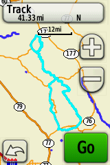
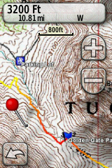
Look for the Shaded Relief toggle on the toolbar. Here’s what it looks like:

(Also find it in the “Map” menu under Shaded Relief).

Land Ownership

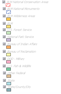
Also new is the Land Ownership layer, which shows which agency (e.g. Forest Service, BLM, etc) owns a particular piece of land. This is very useful for planning exploratory hikes, or perhaps a bikepacking trip. The legend for the colors in the map is here:

http://topofusion.com/images/federal-legend.gif


Color Aerial Download Fix

Finally, some server changes have caused a majority of the maps in TopoFusion’s Color Aerial tileset to fail to download, giving a “map missing” error. If you are seeing these errors for your area, download the latest version and you should be good to go!


Head over to the Download Page to try TopoFusion out, free of charge.

Registered users refer to your registration email for the download link, or go here to request your code and the download URL.

Full list of changes

For a complete list of changes see the Revision History


TopoFusion Pro version 3.85 is out now, in both full and free forms. The biggest feature addition is the wholly revamped Batch Download Tool. This tool allows you to automatically grab massive amounts of map data and store it locally for use offline, or just for use in general. The tool provides space and time estimates and allows you to select which map tilesets you want. Included in this release also is the ability to batch download color aerials as well as maps from any WMS server.

We also added color aerials for the state of Maine, bringing our high resolution color imagery coverage in the United States to all but 5 states. See Color Coverage for more info on color aerial coverage, including an updated map. These aerials come from a variety of servers.

Head over to the Download Page to try TopoFusion out, free of charge.

Registered users refer to your registration email for the download link, or go here to request your code and the download URL.

Full list of changes

For a complete list of changes see the Revision History


The Colorado Trail Race starts Sunday August 2nd, 2009 at 6am from Denver, Colorado. Mountain bikers will race self-supported for some 470 miles, nonstop, until they reach Durango, Colorado. Taking between 4 and 8 days, this is an epic singletrack ride like no other.

TopoFusion author Scott Morris will be there testing his endurance. He also wrote the SPOT tracking software that will be used to view the race unfold, online. A new site has been launched, trackleaders.com, which features exclusive use of the TopoFusion SPOT tracking system.

To follow along with the Colorado Trail Race, go here:

http://trackleaders.com/ctr

About 40 racers will carry SPOT units.


Visit the Archives