
New tutorials – uploading tracks and maps
January 8th, 2010We’ve got two new tutorials here on topofusion.com.
Uploading tracks to Garmin GPS units
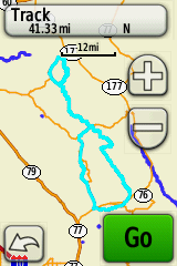
Uploading tracks to Garmin GPS units can be a bit of a mystery sometimes. 10,000 point limits, simplifying, splitting into 500 point chunks, 13,000 points for a course? And it’s a little different for every GPS.
We’ve got a new set of tutorials that should help, written for each of the main GPS “families”. Find it here:
http://topofusion.com/tutorials/uploading-tracks.php
Uploading Custom Raster Maps
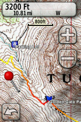
This is a new tutorial that should help people getting started with uploading custom raster maps from TopoFusion to Oregon/Dakota/Colorado GPS units. Or, help those already using it get the most out of the feature:
Find it here:
January 22nd, 2010 at 4:17 pm
I want to find trail maps for Western North Carolina. Where can I find them and how do I upload them into my Garmin Etrex hci>
January 23rd, 2010 at 11:41 am
Hi Dan,
The custom map feature described in the second part of this post isn’t supported by the eTrex HCx. You can, however, upload vector maps using Mapsource software.
There are some free options available, see this thread:
http://www.topofusion.com/forum/index.php?topic=3796.0
I am not sure if NC is covered by the free maps. Otherwise you’ll need to buy a Mapsource Topo product.
Thanks.