
TopoFusion Event Mapping
Here are just a few of the fine events TopoFusion has provided mapping services to over the years. As of 2013/2014 we have largely discontinued our mapping sponsorship and event mapping projects. If you have something special, please do get in touch, but we don't have the resources to offer free/sponsored mapping anymore.This page still serves as an example of some of the maps you can produce using the software.
For help uploading GPS data see Uploading Tracks Tutorial

Grand Junction Off-Road
The Grand Junction OFf-Road is Epic Rides latest mountain bike festival and race, held on some of the most fun and technical trails anywhere. This event has the potential to be an instant classic.
Course Maps:
See epicrides.com Grand Off-Road Course maps for the official course maps, courtesy of topofusion.com
GPS data (GPX format):
GJ 15 Grand Course
GJ 30 Grand Course
GJ 40 Grand Course
Official website: http://epicrides.com
Whiskey Off-Road (updated for 2013)
The Whiskey Off-Road is one of the biggest and most exciting mountain bike events in the country, held in Prescott, AZ Always a good day on the bike.
New for 2013 is a new reroute on the first section of singletrack, to avoid course bottlenecking.
Course Maps:
See epicrides.com Whiskey Course maps for the official course maps, courtesy of topofusion.com
GPS data (GPX format):
Whiskey Course 15 Proof - no reroute
Whiskey Course 25 Proof - with reroute
Whiskey Course 50 Proof - with reroute
Official website: http://www.epicrides.com/wor/wor.htm
The Cascade Cream Puff is a legendary 100 mile mountain bike race held in Oakridge, OR. It's one of the toughest around.
Course Maps Updated for 2011:
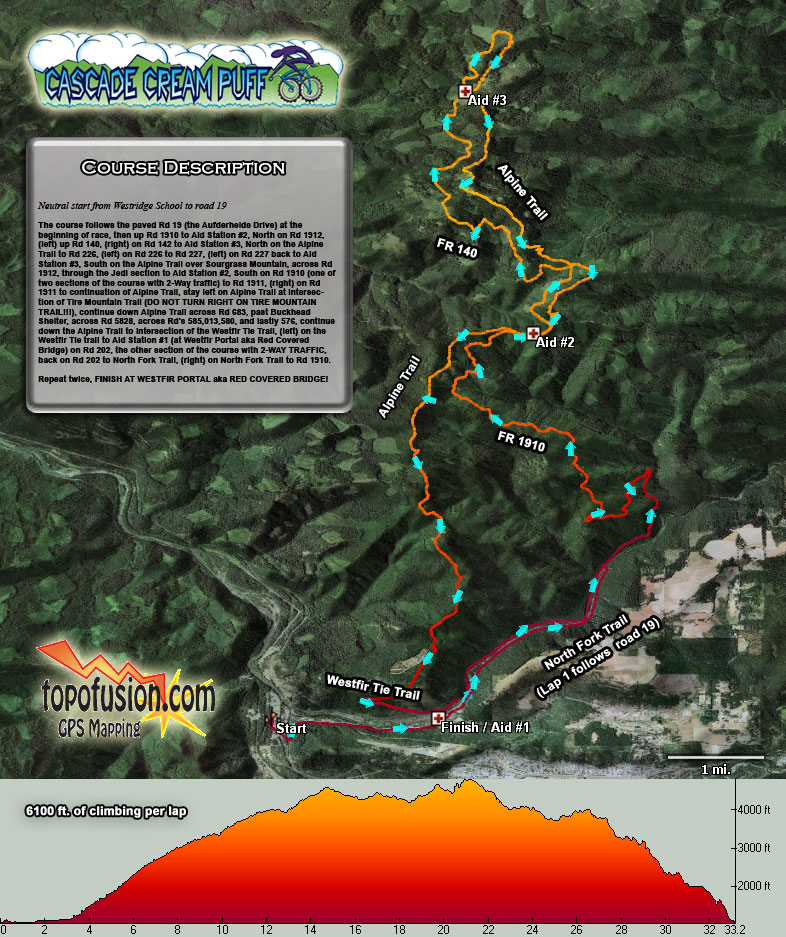
Course overview (color aerial)
Course detail (hi-res topo)
GPS data (GPX format):
CCP2011_v2.gpx
Official website: http://www.cascadecreampuff.com
Sea Otter Classic
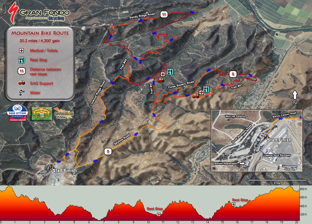
Gran Fondo Mountain Bike Route Map
For GPX data for all 14 courses go to:
http://topofusion.com/maps/seaotter/gpx (GPX directory)
Official course maps are availble here:
seaotterclassic.com/index.cfm/course_maps.htm
Tahoe Sierra 100
The Tahoe Sierra 100 is one of the most challenging ultra mountain bike races in North America, a true 100 mile course, not a lap course. Due to the remoteness, this race differs substantially from other ultra mountain bike races.
Aerial Course Map
Topo Course Map
3D course map
GPX file with waypoints at aid stations

Website: http://www.globalbiorhythmevents.com/2009-tahoe-sierra-50100/
24 Hours in the Old Pueblo Presented by Tucson Medical Center
 The 24 Hours of Old Pueblo keeps getting better and better each
year. The race is over President's Day weekend each February.
The 24 Hours of Old Pueblo keeps getting better and better each
year. The race is over President's Day weekend each February.2012/2013 Old Pueblo GPS data [GPX format]
Gasline Bypass Trail (on-course option) [GPX format]
'13 Course Map:

(click)
Full replay of the 2010 event, with category winners highlighted:
Official Website: http://www.epicrides.com/twofour/24.htm
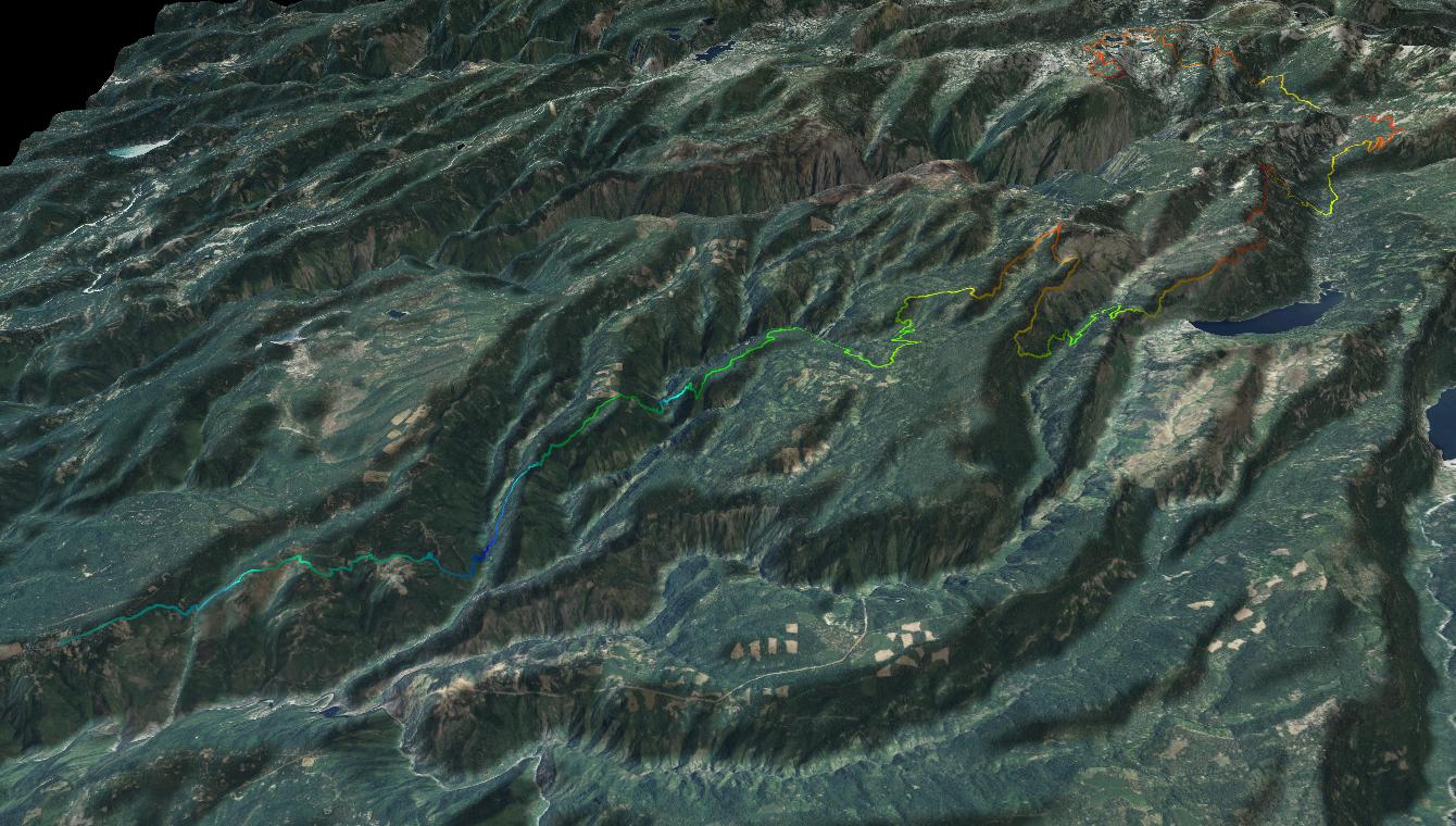
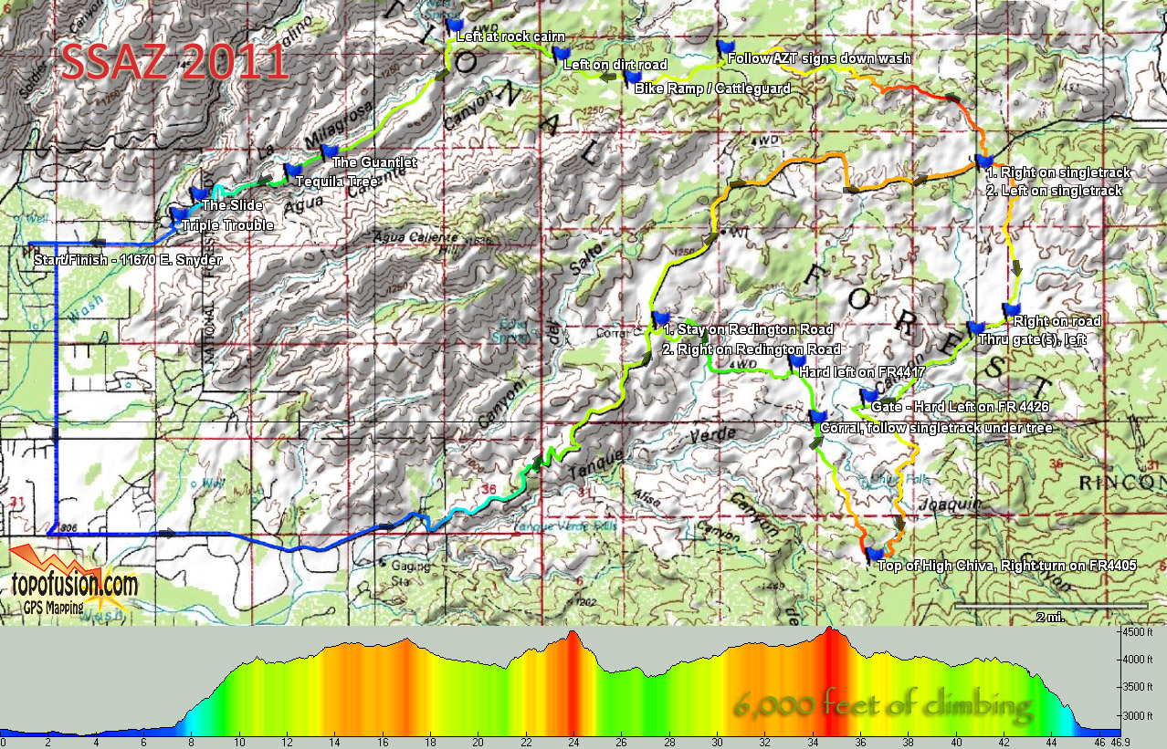
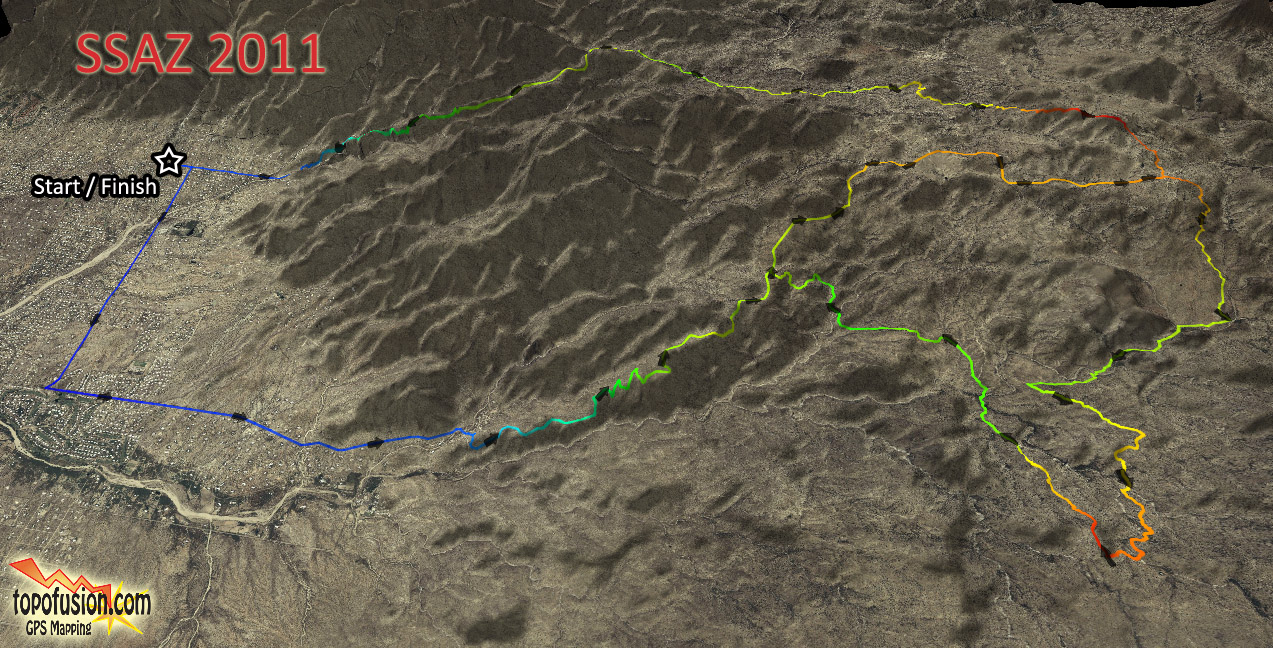
SingleSpeed AZ 2011
47 miles of difficult Sonoran Desert terrain including the world class Milagrosa Ridge for the final descent.
Web Course Map (topo)
Course detail [PDF]
3D course map
Full GPX file with waypoints
Website: http://www.facebook.com/#!/event.php?eid=131208243604661
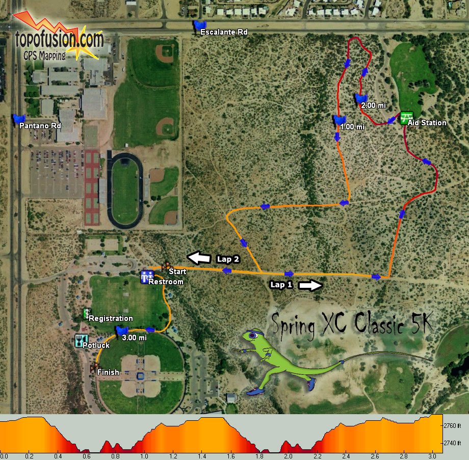
Lincoln Park, Tucson, AZ
The 5K cross-country course winds its way through the desert surrounding Lincoln Park, mainly on dirt trails. The course features a challenging two-loop course with rolling hills through the desert.
TopoFusion took care of the the course mapping and also donated $350 in prize money to the overall winners.
Official course map:
GPX file: SpringXC2009.gpx (course is the same for 2010)
Official Website: http://azroadrunners.org/events/springxc.html
The footing (What footing?) is rocky, muddy (a few river crossings) and loose in places. The trail is not maintained (non-existent) in some areas. We love this stuff and hope you do too. ILK RULES! Bring on the ILK! ILK me! Is the trail as tough as advertised? Yes and No. I't s no run down a nature trail (but at times it is just that), you will get wet and muddy. You won't get swept down stream in any whitewater. Some big hills but no supplemental oxygen is needed. Our descriptions are a disclaimer. All in all, a great run in a beautiful environment...with stupid spots.
Sounds like a great time! Race organizers used TopoFusion to map and tweak the course. And in a special promotion, we've offered a "Dances with Dirt" version of TopoFusion. This free version of TopoFusion doesn't have any Demo tiles obscuring maps, nor is it limited to three files open. It is, however, limited to viewing the area (southern MI and northern IN/OH). This version also includes all the GPS files for the Dances with Dirt course. To download the Dances with Dirt version of TopoFusion, and for some instructions head over to:
Dances with Dirt TopoFusion demo page.
 The Arizona Trail 300
 The Arizona Trail 300 is a self-supported, 300 mile backcountry mountain biking race held on the Arizona Trail. There is no entry fee and there are no prizes. Please see the Arizona Trail 300 site for more details, TopoFusion maps and profiles.
 Arizona Distance Classic
The Arizona Distance Classic is a Half Marathon/5k event held in Oro Valley, AZ (just outside Tucson). Come join in on the second annual event put on by John Bingham Racing. Race date is March 12, 2006.
Half Marathon Map [JPG]
![[JPG]](images/DC-half copy.jpg)
5K Map [JPG]
![[JPG]](images/DC-5k copy.jpg)
Soul Ride 2005 Info (race has been postponed since)
 Watch a GPS replay of the 2004 race.
The Soul Ride is a multi distance (100/60/30/10 mile) event held on October 22nd, 2005 in Oracle, AZ (1 hour from Tucson). It promises to once again be one of Arizona's finest endurance races.
2005 maps:
2005 10 mile map[JPG] [PDF] [TOPO]
![[JPG]](images/soul05/Soul10-2005.jpg)
![[TOPO]](images/soul05/Soul10-2005-topo.jpg)
2005 30 mile map[JPG] [PDF] [TOPO]
![[JPG]](images/soul05/Soul30-2005.jpg)
![[TOPO]](images/soul05/Soul30-2005-topo.jpg)
2005 60 mile map [JPG] [PDF] [TOPO]
![[JPG]](images/soul05/Soul60-2005.jpg)
![[TOPO]](images/soul05/Soul60-2005-topo.jpg)
2005 100 mile map [JPG] [PDF] [TOPO] [3D]
![[JPG]](images/soul05/Soul100-2005.jpg)
![[TOPO]](images/soul05/Soul100-2005-topo.jpg)
![[3D]](http://www.topofusion.com/images/soul05/3d-100-3.jpg)
2005 50k Sole Ride map [JPG] [PDF]
![[JPG]](images/soul05/Sole50k-2005.jpg)
GPS Data - 30 mile course in GPX format
GPS Data - 60 mile course in GPX format
GPS Data - 100 mile course in GPX format
 The Sun Run for Life Directions
The Sun Run is a 10k/5k race held at Reid Park in Tucson, AZ on Sunday January 30, 2005. It is part of the Southern Arizona Road Runner's Grand Prix point series and benefits Life Directions.
Look for free copies of TopoFusion as prizes in the race!
Click here for 10k course map [JPG]
![Click here for 10k course map [JPG]](images/SunRun10kMap.jpg)
Mapping info
We can provide precise GPS course mapping, with an emphasis on accurate elevation gain/loss. We can also produce customized copies of TopoFusion (free for download by any race participant) for course previewing. We can also provide copies of the full version of TopoFusion as race prizes.
However, as noted above, we are no longer looking for events to sponsor with these services. Thanks for the interest.