TopoFusion.com
TopoFusion News
Your source for the latest TopoFusion, GPS and Mapping developments.

GPS Art in TopoFusion

January 11th, 2012 | No Comments

TopoFusion author Scott Morris put together this nifty video using his 2011 GPS tracks to paint GPS Art on a TopoFusion map canvas. The video uses TopoFusion’s multi-track playback feature to replay all tracks at the same time, showing how the painting evolves as the rides get longer.

He writes, For this year’s painting I went a bit less impressionistic. There’s more definition, and individual rides are a lot easier to pick out. The width of the brush is proportional to the time spent ‘out’ and the color is set by an equation based on speed, grade and heart rate (where available). There’s no justification for it, I just played around until I got something I liked. It’s art, you know.. .. I get to do whatever I want!


myTopo maps in TopoFusion

TopoFusion Pro version 4.31 is out, a quick response to a change in one of the software’s key tilesets — the myTopo layer, courtesy of myTopo.com. Originally introduced in v4.0, July 2010, myTopo maps are a major improvement over MSRMaps/Terraserver topo maps, featuring better clarity, more current maps and forest service updates (like forest road and trail numbers).

Last week (10/12/11) a server change caused new maps downloaded by TopoFusion to come in jumbled and corrupted. If you are getting myTopo maps that look like this:


this update is for you. Once you update you can use the reload maps tool (looks like this on the toolbar: ) to point-click and force a re-download of any maps that came in corrupted.

If you haven’t checked out myTopo’s other services, you should. Besides the awesome (and free!) set of Topo map tiles for the entire US (and Canada) they offer some really nice printed map services. If you’re in the market for a printed map, buying one from MyTopo is a great way to say thanks for the free maps in TopoFusion. Check them out by clicking on their logo.


For full details on what else has changed, check the revision history linked below.


Head over to the Download Page to try TopoFusion out, free of charge.

Registered users refer to your registration email for the download link, or go here to request your code and the download URL.

Full list of changes

For a complete list of changes see the Revision History


Land Ownership map set legend

TopoFusion Pro version 4.22 is out, with some nice fixes and enhancements to the software. One key change was the reinstatement of the Land Ownership Layer, which had a very serious server change, rendering previous versions of the software unable to download/display new Land Ownership maps. The land ownership layer has been incredibly useful for our Search and Rescue as well as Trail Planning users, so we are very happy to have it back. Full details on the Land Ownership change: http://www.topofusion.com/forum/index.php?topic=6270.0

For full details on what else has changed, check the revision history linked below.


Head over to the Download Page to try TopoFusion out, free of charge.

Registered users refer to your registration email for the download link, or go here to request your code and the download URL.

Full list of changes

For a complete list of changes see the Revision History


Tour Divide. 2,700 miles from Canada to Mexico. Self supported and on mountain bikes. It’s been called the toughest bike race in the world, and the only way to follow it is by SPOT satellite messengers.

New this year, you can follow along in TopoFusion, and do instant replays of all the action. Here’s an example video of what a race replay looks like:

For details on using the SPOT tracking feature, go to Trackleaders in TopoFusion. Or check out everyone’s latest position over at trackleaders.com:

http://trackleaders.com/tourdivide


Mapquest maps

TopoFusion Pro has a new release, version 4.2, now available. We’ve got some exciting new features, as the software continues to improve. First we have two new map tilesets with global coverage — Mapquest’s street tiles based on Open Street Maps data and also the Open Aerial tileset. Both are great additions to the software, offering a different (and faster) rendering of Open Street Maps data, and in some cases higher resolution color aerial data in the Open Aerial layer.


Also new is a SPOT replay interface. This was produced in collaboration with trackleaders.com who are a leading provider of SPOT-based event and long trip tracking. The new tool gives users access to trackleaders history of events, allowing historical and instant replays of races such as Tour Divide, the Yukon Quest and the Colorado Trail race. There are also tools for following events live in TopoFusion.

As always, we’ve been adding little buttons and tricks here or there, often from user request. For full details on those, check the revision history linked below.


Head over to the Download Page to try TopoFusion out, free of charge.

Registered users refer to your registration email for the download link, or go here to request your code and the download URL.

Full list of changes

For a complete list of changes see the Revision History


We cooked up a fun little project along with the good folks at Epic Rides, promoters of the biggest 24 hour race in the country — the 24 Hours in the Old Pueblo.

The Old Pueblo is Tucson, our home base, and TopoFusion author Scott Morris was out at the race last year, collecting GPS data and having a blast riding bikes in the desert.

We took all the lap times from the race, cloned copies of Scott’s GPX files, and sent the dots out onto the course. What results is the closest approximation to what actually happened in the race that you can come up with.

Click through to our 24 Hours in the Old Pueblo Mega Replay page for more info and several videos, including a category winners and solo men, among other categories.


TopoFusion Pro v4.1 Out!

February 1st, 2011 | 1 Comment


new 2011 splash screen

TopoFusion Pro has a new release, version 4.1, out the first of February, 2011. This version has a long list of changes (see revision history below). Many were requested changes to the user interface, or small added features. A lot of times our users know better what the software should do than we do — we love getting feedback!

A few examples include – higher detail myTopo maps, functions to strip time stamps from files, correct elevation, expire Open Street Maps tiles, add recent files from a GPS’s archive when downloading, and significant improvements in usability and efficiency in TopoFusion’s unique GPS network function.


Head over to the Download Page to try TopoFusion out, free of charge.

Registered users refer to your registration email for the download link, or go here to request your code and the download URL.

Full list of changes

For a complete list of changes see the Revision History


Version v4.05 of TopoFusion Pro was released today. This version introduces a new map type, “Elevation” which brings vivid colors, shaded by elevation. These can be great for large scale maps, and also as a powerful visualization tool to help understand an area. Elevation affects so much — vegetation, soil, temperature! The screen shot above is an elevation map in 3D mode, where purple and white represent areas above tree line, and brown/gold/green the lower elevations.

Here is another example, this time using colored sharp contours, and the “combo” feature to combine the elevation map with a myTopo map.

This version also fixes a number of small issues from the first v4 release this summer.


Head over to the Download Page to try TopoFusion out, free of charge.

Registered users refer to your registration email for the download link, or go here to request your code and the download URL.

Full list of changes

For a complete list of changes see the Revision History


Outside magazine’s blog posted an interview with TopoFusion’s founder, Scott Morris. Get a little insight into the back story behind TopoFusion and SPOT satellite tracking (trackleaders.com), also covering topics on bikepacking and big ‘old long MTB races like the Colorado Trail Race.

Outside interview: TopoFusion’s Scott Morris, Brains and Bikes.


We are happy to announce the release of version 4.0 of TopoFusion Pro! The software has come a long way since v3.0, the last major revision, and we hope you are as excited about the improvements as we are.

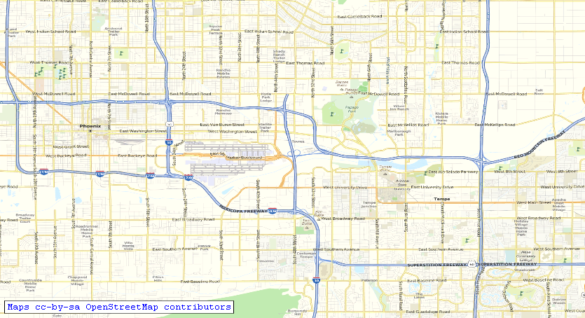
Since the latest release (v3.973) we have added several map types, including new topo maps courtesy of myTopo.com and street maps from the Open Street Map project. The partnership with myTopo is particularly beneficial for TopoFusion users, since they are both more up-to-date and better quality USGS topo maps than the standard topo maps available in TopoFusion since v1.0 — those from Terraserver (now MSRMaps.com). Here is a quick comparison.

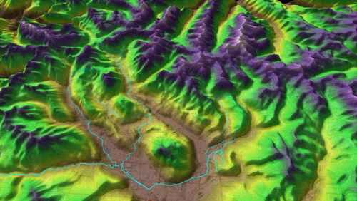
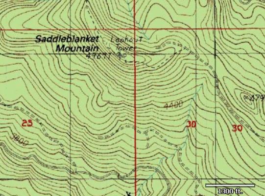
Terraserver (old maps):


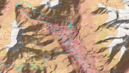
And new maps from myTopo, only available in TopoFusion Pro v4.0:


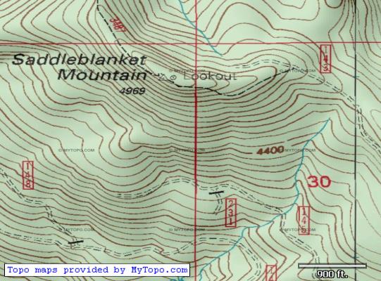
Note the higher quality scan and also the addition of forest road and trail numbers — very useful when planning your next foray into the outdoors.

We want to thank the good folks at myTopo for the partnership, and encourage all our users to check out their map printing services. Head over to myTopo.com, or use the “Order Printed Map” command, available in the File menu in TopoFusion, to jump into myTopo’s easy to use map ordering engine. They produce a nice product!

There are other new features in v4.0, like a new fully functional FUSION Combo mode that allows GPS mappers to blend any two map types — including myTopo, color aerials and open street maps, allowing for some very unique views. Check it out and help us spread the word — TopoFusion 4 is here!


Head over to the Download Page to try TopoFusion out, free of charge.

Registered users — upgrades are always FREE — refer to your registration email for the download link, or go here to request your code and the download URL.

Full list of changes

For a complete list of changes see the Revision History


Visit the Archives