TopoFusion.com
TopoFusion News
Your source for the latest TopoFusion, GPS and Mapping developments.


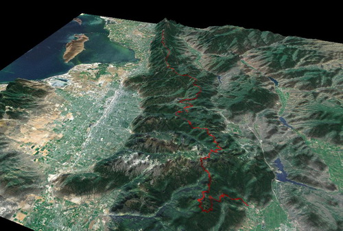
new Landsat, new elevation data

As posted earlier, our trusty OnEarth server ceased giving out Landsat and Elevation tiles in the last week. Version 4.81 replaces OnEarth with a different NASA server, and there are some improvements! First, elevation data is global — earlier versions of TopoFusion had no elevation data in extreme latitudes (60 degrees+). 3D in Alaska! Second, the Landsat imagery is higher quality, better true color, and still covers the whole world. This is definitely an improvement for non-US users of TopoFusion.

We also added the Juicy Trails tileset, which is a very nice rendering of OSM street, topo and (most importantly) trail data. See http://juicytrails.com for more info, but this is a very nice tileset to have available in TF. Please consider adding trails to the OSM database (which will then be reflected on Juicy Trails, too).

Update your TF and check it out (full list of changes below), or if you are new to TopoFusion, please try the demo. And as always, let us know what you think, especially if you have a suggestion for a new feature or different way the software should work.

Thanks!

Team TopoFusion


Head over to the Download Page to try TopoFusion out, free of charge.

Registered users refer to your registration email for the download link, or go here to request your code and the download URL.

Full list of changes

For a complete list of changes see the Revision History, or keep reading here:

4.81 ā€“ [8/18/13]

Added new server for Landsat and Elevation data
OnEarth server has been retired
Elevation data now available above 60* and below 60*!
Removes issues between NED (US only) and SRTM (global)
Option for force SRTM removed
Landsat imagery now true color reflectance (instead of Mars-like color)
Better resolution, especially outside the USA
Fixed moving time calculation for reversed tracks in profile tool
Increased possible size of KMZ tiled map exports
Fixed profile errors with tracks missing time, introduced in 4.78
Added Trackleaders FastMarker export
Added Juicy Trails tileset ā€“ ā€˜Jā€™ key shortcut
Fixed KMZ tiled map exports for over 500 tiles at a time
Fixed speed display for sub-second GPX files


At this time the NASA OnEarch server has ceased operation. I’m not 100% certain that it is a permanent downtime, but it may be.

I am working on replacements, and will have a new release out as soon as I can.

What this means is that current copies of TopoFusion cannot download Elevation Data or Landsat tiles. You’ll get a “TF is having trouble contacting…” error.

Thanks for the patience, and stay tuned for further updates.

Scott
Modify message


TopoFusion displaying Person Last Seen distance rings, and new address search feature

TopoFusion v4.76 is out and ready for download! This version adds a handy tool for navigating to new places — a much improved address or city search feature. CTRL-F brings up the search window, or find it in the “Goto” menu. It’s tied to Mapquest’s nominatim service, which is built from Open Streetmap data. So that means your copy of TopoFusion needs to be connected to the internet to search addresses, but that isn’t much a problem since it needs to be in order to download new maps as well.

Address search was a feature requested of us by the Search and Rescue community. And we’ve added a PLS (Point Last Seen) feature for them as well. Mark a waypoint as a PLS symbol type and you can get user configurable distance search rings around that point.

We’ve also significantly improved the handling of bad and slow server responses. Red cross marked appear on the download tiles now, showing when downloads are being sluggish. With so many awesome servers that TopoFusion pulls from, they can’t all be up all the time. So these tiles, and better handling of them, can clue you to use a different server for the time being. Luckily there are 3 or 4 sources of Topo maps and 3 sources of Color Aerial data, so there’s always other choices. Not to mention other cool maps like Open Street, Open Cycle, Landsat, colored Elevation and BLM Land ownership.

Update your TF and check it out (full list of changes below), or if you are new to TopoFusion, please try the demo. And as always, let us know what you think, especially if you have a suggestion for a new feature or different way the software should work.

Thanks

Team TopoFusion


Head over to the Download Page to try TopoFusion out, free of charge.

Registered users refer to your registration email for the download link, or go here to request your code and the download URL.

Full list of changes

For a complete list of changes see the Revision History, or keep reading here:

4.76 – [4/30/13]

Added address searching feature (Goto->Search Address)using MapQuest’s nominatim
service, based On Open Street Map data. CTRL-F brings up search dialog. Requires
Internet access. Replaces old “GIS Layers” city search.
Improved handling of bad/down/slow server responses
“Downloading disabled” message only appears when tileset you are viewing is
having trouble
Added “Retrying” tiles to better show server response times/errors
Increased size and length of time photos stay visible in upper/right during
Single track playback
Improved time/elevation reading of raw NMEA log files (.log import)
Fixed reporting of free memory, disabled display of tile memory cache size
Fixed thread errors loading networked KML files
Fixed memory leak in tile downloading stack
Reordered Map Menu to better reflect priority/reliability of tilesets/servers

4.73 – [2/7/13]

Downloading from .FIT devices (eg Garmin 800) retrieves only last 24 hours
by default.
Fixed temperature plots and shading for sub-zero (F) temperatures
Added support for new SPOT-API .spot files (read/write), also “save as..”
for .spot files.

4.72 – [1/3/12]

Fixed files not opening when double-clicked and TF already opening
Additions to Mariposa UA GPS analysis tool.

4.71 – [11/8/12]

Added range rings for PLS type waypoints (Search and Rescue). Choose PLS for
waypoint symbol, then set interval between range rings in the “Comment” field
Fixed non-functional “Old Topo” menu item in the map folder


TopoFusion displaying temperature data for a long ride

We’re happy to release TopoFusion 4.7! This version offers some significant improvements to the software in usability, some needed fixes and cool new stuff too. New is support for Garmin’s Tempe sensor, an inexpensive temperature sensor that can be paired with many Garmin GPS units. With that support comes temperature profiles (see above screenshot) and temperature-based track shading. In the new support department we also have new Edge 800/500 and Fenix support, in the form of .FIT file reading. Plug your Edge 800 up and you can pull up any file from your history in TopoFusion!

We’ve also got a new mouse tool mode — the info mode, which gives you track and waypoint data simply by moving the mouse near points in the map. This is a user requested and highly useful form of additional track/trip analysis. Thanks for the suggestion!

TopoFusion’s “Export View” function is a very powerful way to output high resolution maps, with any of TF’s map sets and user track/waypoint data as well. But one issue was that tracks and waypoint text were pretty tiny when exports are at 8000×8000 pixels. Now there’s a handy checkbox that adds automatic scaling of line width and font size.

Update your TF and check it out (full list of changes below), or if you are new to TopoFusion, please try the demo. And as always, let us know what you think, especially if you have a suggestion for a new feature or different way the software should work.

Thanks

Team TopoFusion


Head over to the Download Page to try TopoFusion out, free of charge.

Registered users refer to your registration email for the download link, or go here to request your code and the download URL.

Full list of changes

For a complete list of changes see the Revision History, or keep reading here:

4.7 – [11/1/12] (Full Release)

Added support for per GPS point temperatures (e.g. Garmin Tempe sensor)
Including profile tool, track shading, track properties
Added ability to read .FIT files
Added support for Garmin Edge 800/500, also Fenix and any other units that
communicate by .FIT files
Added new mouse mode: Info Tool. Use to query tracks and waypoints to
get on-screen stats. Clicking on a point brings up it’s properties view.
Added option to scale line width, fonts and waypoint sizes when exporting maps
(Export View function). Checkbox turns on scaling to match what is seen in
current map view
Added shortcut to “Reset TopoFusion to default settings” to start menu on
install. Useful for debugging issues with the software (more effective than
uninstall/reinstalling).
Improved download queue behavior when a tileset (server) is unresponsive
Improved shaded relief quality in highest detail setting (when zoomed in)
Improved speed of filling track points table in File Properties
Files with less than 8000 points now loaded by default
Fixed access violation in using “Merge Files and save as…” when using edited
tracks with deleted points or files with multiple un-named tracks
Fixed crash in using the merge tool to save out empty files (nothing merged)
Fixed error disabling downloading with modal forms shown (about, options)
Fixed ‘Real Time Playback’ option in multi-playback when using skip stopped time

4.66 – [9/7/12] (Beta)

Changed Astro live tracking centering to only center, not zoom on track
Fixed off by one error(s) converting trackpoint to waypoint
Improved display of downloading tiles while drawing tracks
Added ability to save kml/tcx/shp file when creating a new file with waypoints


Original TF Logo / Site design

TopoFusion is 10 years old! The program has come a long way since the initial release on September 16th, 2002. It was a pretty bare bones piece of software compared to what it is today, but still had nice features and innovations that we take for granted today.

It was the result of an intensive summer spent programming and riding bikes. Alan and Scott Morris worked in different locals (Arizona and Utah) collaborating and sharing code and ideas as it went. They both had a full load of classes at the University of Arizona that started in the fall, but were able to push it out a few weeks after courses start.

Here’s the first announcement made, to the usenet newgroups “alt.satellite.gps”:

TopoFusion – New Topo/Aerial GPS Mapping Software

Back then the only map server was Terraserver (now there are over a dozen), no 3D, no user maps, no WMS support, no DEM data, and on and on.

We’d like to thank all the users of the software (registered or not) for supporting us throughout the years. TopoFusion has been a wonderful “job”, from getting to use the software ourselves (we love it), interesting programming challenges, to meeting lots of great folks and hearing about how they use the software. It really has been surprising to see the wide variety of people and uses that find the software to fit their needs.

To celebrate, we’re offering 30% off any version of TopoFusion. Use the following code at checkout.

(Sale is over, sorry!) Here’s to another 10 years of awesome GPS Mapping! Thanks!!


Head over to the Download Page to try TopoFusion out, free of charge.

Registered users refer to your registration email for the download link, or go here to request your code and the download URL.

Full list of changes

For a complete list of changes see the Revision History


Color Aerials

We’ve pushed out a new version of both TopoFusion Basic and Pro to address some server changes. The changes on the server end have rendered older versions of TopoFusion unable or hindered in downloading tiles from the Color Aerial tileset (“Color”) and newly added US Topo tilesets. So if you have been experiencing “TopoFusion is having trouble contacting…” errors, or missing map tiles, you will want to update to the latest. We’ve also cleaned up a few things in the error handling of some other tilesets, and enabled batch downloading and combo blending for the reinstated MSRMaps tilesets, as requested.

We have bigger changes in the works, but not ready for prime time yet. Just needed to get this very important maintenance release out. Check it out below.


Head over to the Download Page to try TopoFusion out, free of charge.

Registered users refer to your registration email for the download link, or go here to request your code and the download URL.

Full list of changes

For a complete list of changes see the Revision History


After announcing that MSRMaps.com (formerly Terraserver) will be closing permanently, Microsoft has decided to keep the service alive. They received enough requests from longtime users and folks that rely heavily on the service. If you sent a note in, thank you!

This has, in turn prompted us to release another revision that re-enables access to new MSRMaps tiles. So the traditional Topo maps, B/W aerials (still useful!) and urban imagery for some cities, are all back! The new USTopo layer is still available as well, so now there are three sources of Topo maps in Terraserver! The array of maps available to TF users continues to grow…

v4.6 also fixed a bug created by the massive size of this year’s Tour Divide race. The Trackleaders spot replay interface had a problem replaying the current race. Tour Divide is an exciting race that continues for weeks, so there is still time to get in on the action and do your own replays in TF. Check out more at:

Trackleaders / TopoFusion.


Head over to the Download Page to try TopoFusion out, free of charge.

Registered users refer to your registration email for the download link, or go here to request your code and the download URL.

Full list of changes

For a complete list of changes see the Revision History


We’re happy to announce the release of v4.5 of both the Pro and Basic product. The main new feature is the addition of the “US Topo” tileset, which replaces the now deprecated “Topo” tileset. The old Topo tileset was downloaded from MSRMaps.com (formerly Terraserver) which has been shut down (read details here: MSRMaps shutting down).

Previously downloaded maps in the old Topo tileset will still be available to existing users, but future downloads have been disabled. For more details, read the forum thread:

http://www.topofusion.com/forum/index.php?topic=7159.0


Head over to the Download Page to try TopoFusion out, free of charge.

Registered users refer to your registration email for the download link, or go here to request your code and the download URL.

Full list of changes

For a complete list of changes see the Revision History


We regretfully report that Microsoft’s MSRMaps server (formerly known as Terraserver) is shutting down. For the last 10 years, MSRMaps has given TopoFusion its base “topo” and black and white aerial tilesets for the United States. After May 1, copies of TopoFusion will no longer be able to pull new tiles for either of these tilesets. Might be time to do some batch downloading!

Here is the official announcement:

http://msrmaps.com/About.aspx?n=AboutShutdown

Terraserver was a key piece in creation of TopoFusion, so it’s with a heavy heart that we bid farewell to it. Fortunately we still have great tilesets like MyTopo, Open Cycle Map, Color Aerials, Open Aerial, Canadian Topo’s, among many others! Terraserver maps were getting quite out of date, and I don’t think any of our users base relied on the old black and white aerials any more since they have been superseded by more up-to-date and color aerial images. Still, sometimes the superfast load times and older sourced maps did come in handy, so we’ll miss it.

There’s still time to download and permanently saved Terraserver tiles to your TopoFusion map cache! Get downloading!

Edit: See new version 4.5 for the new US Topo tileset, with the same Topo maps as MSRMaps.


Lee Blackwell, Gila River Country, Arizona

TopoFusion Basic has received a major overhaul and now joins the same codebase as TopoFusion Pro. It’s a slimmer, more easy to use version of our Pro software with some of the advanced features disabled. The old version of TopoFusion Basic (v2.975) is now known as TopoFusion Legacy, since it still runs well on older version of windows (95/98).

Any users of TF Basic should update to get a host of new imagery and other updates found in the Pro codebase. We’re confident that the new Basic product will suit many of our users, while the Pro version is the flagship product with all the bells and whistles such as:

  • Shaded Relief mapping for all map types
  • Climbing Analysis
  • GPS Networks
  • Lap Analysis
  • Elevation Tiles
  • Batch downloading of map tiles
  • Improved track manipulation
  • WMS server support
  • Cycling Power functionality. Also Heartrate and Cadence visualization.
  • Add and calibrate your own maps – user calibrated maps with transparency
  • PhotoFusion features
    • – Thumbnails on map – mouse over enlarges
    • – Photos as waypoints – can be moved/deleted/added

TF Legacy will remain available to license holders of both the Pro and Basic versions, and also in demo form.

For full details on what else has changed (v4.4 is also available for TF Pro), check the revision history linked below.


Head over to the Download Page to try TopoFusion out, free of charge.

Registered users refer to your registration email for the download link, or go here to request your code and the download URL.

Full list of changes

For a complete list of changes see the Revision History


Visit the Archives