
Profiling the Appalachian Trail
January 20th, 2008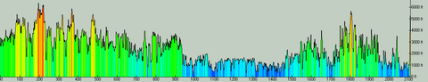
At over 2100 miles, the Appalachian Trail pretty much defines the word “epic.” The original thru-hiking trail, it attracts thousands of adventure seekers each year.
TopoFusion was approached to undertake the difficult task of profiling the entire AT. We didn’t have to hike the entire trail, but there was quite a bit of data processing and extension of the software. All fun stuff as long trails like this really capture our interest and imagination.
The result is above — the entire AT profiled to high detail. According to Climbing Analysis, there’s over 500,000 feet of climbing on the trail. Think about that number for a while. That’s a lot of vertical.
Anywho, the profiles can be seen in the latest and greatest hiker’s handbook to the trail, Appalachian Pages by David Miller. The profile lines are watermarked vertically behind the mileage cues and narrative, giving a very handy reference while out on the trail. Check it out.

We’ve made the AT GPS data available for download from TopoFusion. This includes GPX and KML files for both the entire trail and all the shelters. Head over to: