
v5.7 Released – Advanced Track Tools, NZ/OZ topos added
Monday, May 18th, 2020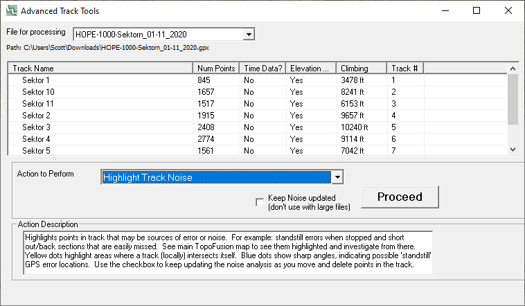
new Advanced Track Tools dialog in TopoFusion
There’s been plenty of time for programming lately and TopoFusion has some awesome new features. The “Advanced Track Tools” dialog is aimed at users that want to create and distribute high quality GPS tracks. There are easy tools to simplify, add elevation data and smooth that data. A unique feature is the ‘Highlight Noise‘ mode that will help identify errors in a track. It highlights any local intersections on a track in yellow, and any areas of repeated high angles in blue. Intersections (yellow) often mean there’s a small out/back section of track, or a section of backtracking that might not be visible, especially when zoomed out. Sharp angles (blue) are often indicative of a cluster of standstill random GPS error points — if, say, the GPS or phone was left tracking for some time while not moving.
One target audience here is a race director or someone otherwise charged with producing and editing a high quality GPS file. Statistics will be more accurate and anyone using the track to follow while in the field will be a happier camper.
In our work over at Trackleaders we see hundreds of race routes per year, and the quality varies. The hope is that with these tools some folks will be able to produce their own high quality tracks.
-
List of all functions in Advanced Track Tools:
* Full file simplify
* Highlight track noise (standstill and track intersections)
* Interpolate track segments to minimum distance
* Reorder (sort) waypoints based on track
* Strip time/cad/hr/power (already found in File Properties)
* Add elevation to track (with new max detail option)
* Smooth elevation (already found in File Properties)

packrafting on New Zealand’s west coast
New Topos – if you follow along with Scott and Eszter’s adventures over at the diary you may have seen the recent obsession with Oceania — New Zealand and Australia. We’re happy to release a new map mode (use shortcut key “Z”) that downloads high quality topo maps for all of Oceania!
Also check out the 2nd high quality topo maps, now available as USGS Topo under the “G” key. It’s a good time to be planning and mapping adventures! Full list of changes can be found at revision history.
To encourage further adventure planning while staying home (where needed), we’re continuing our TopoFusion sale. Through end of May you can take 40% of TopoFusion. Just use the coupon code “SMALLBIZ“. Good for single and multi-person licences, and both Pro and Basic versions of the software. (Single Pro license normally $69.95, down to $41.97).
Thanks for supporting this small business through a challenging time!
Purchase link:
And don’t forget to add the coupon code.
![]()