
v3.93 out – upload TF maps to Oregon/Dakota/Colorado GPS!
Tuesday, October 27th, 2009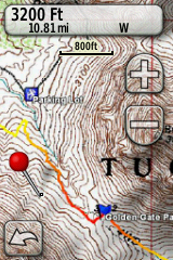
What’s this? TopoFusion maps on a Garmin handheld unit? Yep!
After years of explaining to users that TF’s raster maps cannot be uploaded to Garmin units, the day has finally come!
Garmin has released beta firmware for all GPS units in the Oregon/Dakota/Colorado lines that allows them to display custom raster maps. You can read a few details here:
http://garmin.blogs.com/creating-and-using-garmin-custom-maps-in-five-easy-steps.html
But TopoFusion makes it even easier than that. Simply point TopoFusion to the view of the map you want (using any of TopoFusion’s imagery, even user maps), go to Export View, and select the “Export KMZ to Garmin GPS” option. TopoFusion will find your GPS, and ask you to name the .KMZ file in the “CustomMaps” directory on your GPS. It’s as easy as that.
There are a few caveats, of course. One is to keep the map size below 1024×1024. Larger maps will work, but get downsampled by the GPS once it is loaded. You may also want to control the “Draw Order” parameter to work with overlapping maps and also any Mapsource basemaps you may have loaded (<50 Draw Order and the map shows up under Mapsource maps, >=50, the map will draw on top of it).
We’re very excited about this feature and plan to keep optimizing and developing for it. Stay tuned…