
GPX Maps
Welcome to TopoFusion's free GPS data pages. GPX is an open GPS data exchange format. It is the primary data format used by TopoFusion and other GPS mapping programs. The following GPS maps are in GPX format and can be viewed with any GPX capable program. You may need to select Save as.. in your browser to download the files.Appalachian Trail GPS
Complete GPS data for the Appalachian Trail can be found on the TopoFusion Appalachain Trail GPS page. Includes elevation data, google earth files and shelter waypoints.
Fantasy Island
 Fantasy Island is a mountain bike playground in Tucson, AZ. It
features over 16 miles of twisty desert singletrack that was built by
mountain bikers for mountain bikers. This map covers all of the many
loops available and has some of the cool features labeled (half-pipe,
over and under, etc).
Fantasy Island is a mountain bike playground in Tucson, AZ. It
features over 16 miles of twisty desert singletrack that was built by
mountain bikers for mountain bikers. This map covers all of the many
loops available and has some of the cool features labeled (half-pipe,
over and under, etc).
View Fantasy Island Map in Jpeg format.
Download Fantasy Island data in GPX format.
NOTE: A state trust land permit is required to ride at Fantasy Island. For information on state land permits, see State Land Permit. Moab Riding
The following are a collection of tracks during a short trip to Moab, UT during Thanksgiving 2003. Trails included: Sovereign Singletrack, Amasa Back, Porcupine Rim (partial) and Slick Rock (partial).
Download Moab Thanksgiving in GPX format.
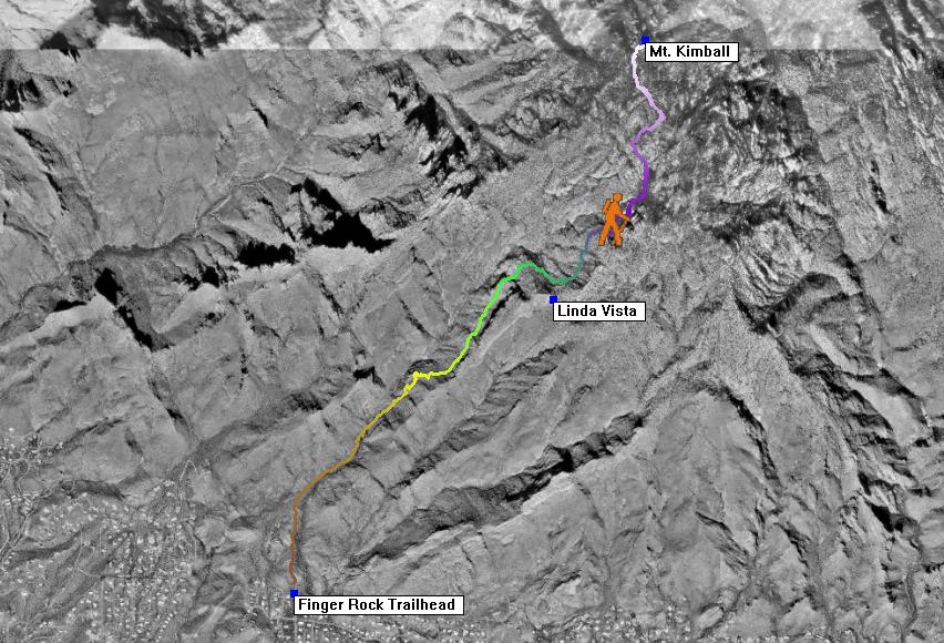
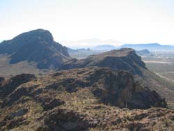
Mt. Kimball
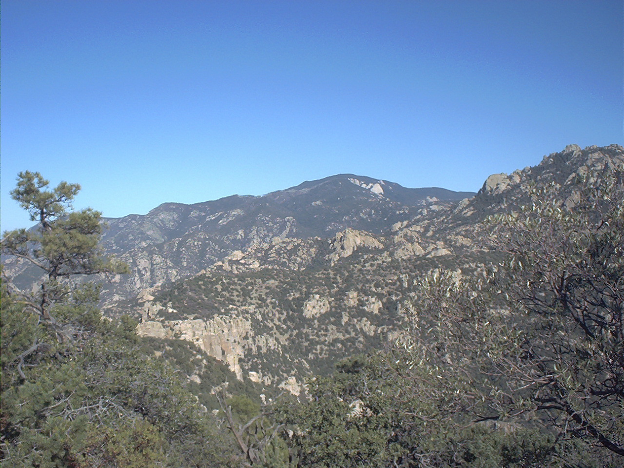 Mt. Kimball is one of the high points of the Catalina front range.
The most direct route to the summit is from the Finger Rock Trail at
the north end of Alvernon Way. The trail is fairly rough and quite
steep for the first few miles. Once atop Mt. Kimball excellent views
of Samaniego ridge and the north side of the Catalinas are attained.
Mt. Kimball is one of the high points of the Catalina front range.
The most direct route to the summit is from the Finger Rock Trail at
the north end of Alvernon Way. The trail is fairly rough and quite
steep for the first few miles. Once atop Mt. Kimball excellent views
of Samaniego ridge and the north side of the Catalinas are attained.
View Mt. Kimball Aerial Map in Jpeg format.
Download Mt. Kimball data in GPX format.
See the Sierra Club's description of this hike.
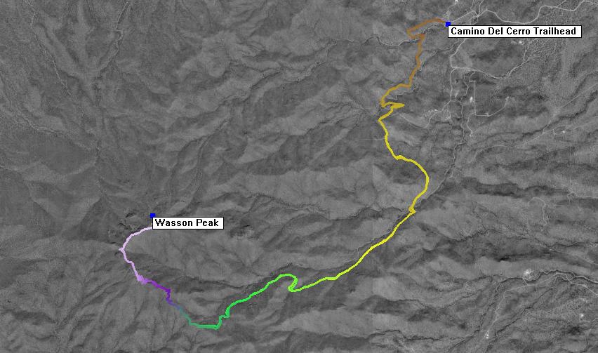
Wasson Peak
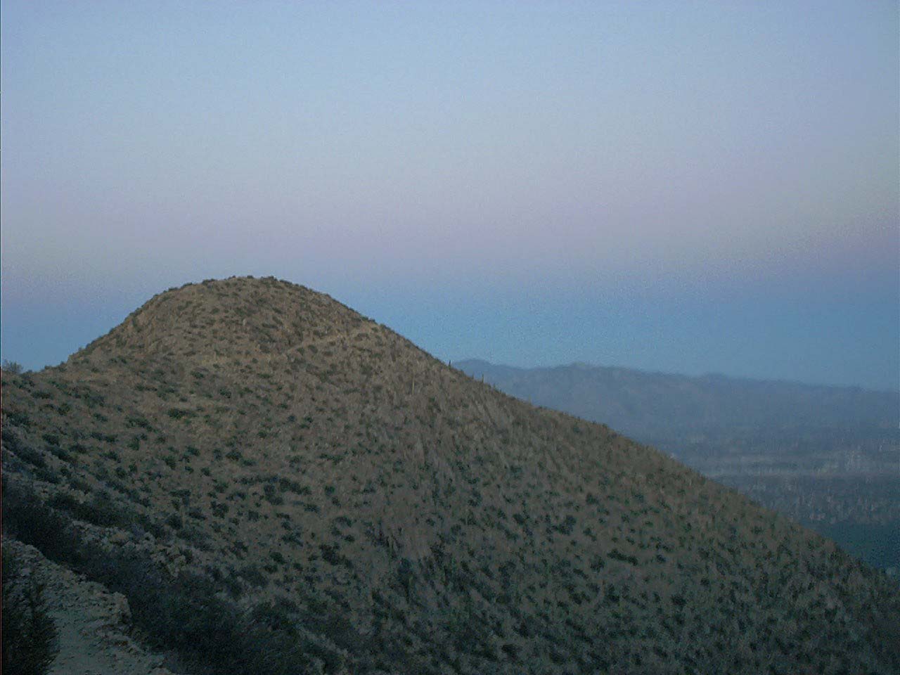 Wasson Peak is a classic hike in Saguaro National Park West. The
destination is the high point of the Tucson Mountains at 4687 feet,
Wasson peak. This map is of the eastern approach, from the trailhead
at the end of Camino del Cerro on the west side of town. This
approach is about a mile longer than the traditional route from King
Canyon.
Wasson Peak is a classic hike in Saguaro National Park West. The
destination is the high point of the Tucson Mountains at 4687 feet,
Wasson peak. This map is of the eastern approach, from the trailhead
at the end of Camino del Cerro on the west side of town. This
approach is about a mile longer than the traditional route from King
Canyon.
View Wasson Peak Aerial Map in Jpeg format.
Download Wasson Peak in GPX format.
GPX Networks
The following GPS maps were generated automatically from overlapping input tracks by TopoFusion's network algorithm. Each segment in the networks is a single track and trail junctions are labeled with waypoints. These files will load successfully in other GPX supported software (as well as in TopoFusion). To get the full benefit of displaying, profiling and creating new routes with these networks you need TopoFusion.All of the maps available here include descriptions of each trail segment and waypoint. Right click on a segment in TopoFusion and choose "Edit Track Properties" to see the description.
Brian Head
 Brian Head is a town and ski resort in southern Utah. It is home to many
superb mountain biking trails, including the epic Virgin River Rim
trail. It hosts the Brian Head Epic 100 mile mountain bike race as
well as other regular distance races. It's best to visit in the
summer to escape the heat -- all the trails are above 8000 feet, and
some go to 11,000. This network file is available as part of the
TopoFusion demo.
Brian Head is a town and ski resort in southern Utah. It is home to many
superb mountain biking trails, including the epic Virgin River Rim
trail. It hosts the Brian Head Epic 100 mile mountain bike race as
well as other regular distance races. It's best to visit in the
summer to escape the heat -- all the trails are above 8000 feet, and
some go to 11,000. This network file is available as part of the
TopoFusion demo. Download Brian Head Network in GPX format.
Starr Pass
 Starr Pass, otherwise known as Tucson Mountain Park, is host to many
miles of rugged desert terrain. It is a favorite of local riders. You
can ride as long as your body can take the abuse. Starr Pass is also
unique in that it is has a very complicated network of trails. This
network covers most of the major trails. We will be updating an
expanded Starr Pass network soon.
Starr Pass, otherwise known as Tucson Mountain Park, is host to many
miles of rugged desert terrain. It is a favorite of local riders. You
can ride as long as your body can take the abuse. Starr Pass is also
unique in that it is has a very complicated network of trails. This
network covers most of the major trails. We will be updating an
expanded Starr Pass network soon.Download Starr Pass Network in GPX format.
Other Free GPX map resources
redtrails.com - Free GPX files and guidebook info with a nice MS virtual earth map interface
bikepacking.net - GPX files and route info for long distance bikepacking trails
Travel by GPS - Very high quality GPX data and info for all types of adventures
Singletracks.com - One of the best sources for quality GPX files, especially if you are a mountain biker.
Trailregistry.com - A user submitted database of GPX files.
TopoShare.org - User submitted tracklogs with google maps interface
CrankFire.com - User submitted bike GPS files in Conneticut
Salt Lake Cycling - Road bike routes around SLC in GPX format.
Water Trails - User-edited water trails for kayaks and canoes in the San Francisco Bay Area
Mountain Bike Directory - check the GPS / Mapping category
Links to other excellent places for Southern AZ trail information
Scott Cherba's Adventures in Tucson Mountain biking. - Excellent trail guide and pictures.
SDMB's trail descriptions and maps - Good descriptions of many popular rides in the area. Most of the maps were made from GPS data, but the data itself is not available.
SAMBA's maps - A few good maps, but many contain trails traced by hand--not collected with GPS data, so I would not trust them. No ride descriptions.
Virtual Tucson Magazine - Some writeups and pictures from local popular rides.
Last, but not least, Tucson Bike map from Pima county. Find the best routes to ride to the ride--even Mt. Lemmon trails can be ridden to with a little effort.
NOTE: You may need to right click and select Save As... also, your browser may add the .xml extension to the files. The correct extension for the files is .gpx