Show Posts

This section allows you to view all posts made by this member. Note that you can only see posts made in areas you currently have access to.


Messages - ScottMorris

Pages: 1 ... 18 19 [20] 21 22 ... 32
951
Uploading tracks to Garmin GPS units can be a bit of a mystery sometimes.  10,000 point limits, simplifying, splitting into 500 point chunks, 13,000 points for a course?  And it's a little different for every GPS.

We've got a new set of tutorials that should help, written for each of the main GPS "families".  Find it here:

http://topofusion.com/tutorials/uploading-tracks.php

952
Sweet.  The 116 is going to be a long day on the bike.......  see you there!

953
GPS, Trails, Training / No support for Triton units in TopoFusion
« on: January 07, 2010, 02:55:38 PM »
TopoFusion cannot talk directly to any Magellan gps units in the Triton line.  The reason is that Magellan has not released a protocol spec, so we don't even have the option to add support.

I suggest exporting directly to a GPX file and then opening that in TopoFusion.

Thanks.

954
Feature Requests / Re: GMAP4
« on: January 06, 2010, 03:12:28 PM »


Interesting, thanks for the note.  I have seen MyTopo maps as a part of other google maps based sites, but hadn't really looked at the details yet.

I did a quick scan and while the topos look good in some places, some are faint and I've noticed some registration problems:


Still, I would love to add this as an alternate to Terraserver.

However, the functionality of TF may be such that they aren't keen on us using their maps.  The fact that TF stores/caches map data permanent, that it includes a batch download tool and some other considerations might make it hard.

But I will try contacting them and see what they think.

955
User Projects / Quantum Physics - GPS replays
« on: January 06, 2010, 10:01:47 AM »

One of my favorite things about mountain biking is you don't have to drive to play.

The options are endless when you leave from home on a bike. What if all possibilities happened at the same time?

This video explores that, replaying several thousand mountain bike rides that started from this Tucson mountain biker's home.


Or, as my girlfriend said as she walked by, "do you have an ant problem in your computer?"

Another way of looking at it is that you leave a trace everywhere you pedal, and indeed glycogen and time -- life -- is burned everywhere you go.  Simply by being there, you change what there is, what it becomes.  And you change yourself.  This video shows the weaving of the 'rich tapestry of life', or my Tucson MTB neural network, at about 250,000x real time.


The lines get darker and thicker the more a route is traced.  You can see my favorite trails very clearly.  So many rides, so much time and energy well spent.  The red lines remind me of blood veins, with my house as the 'heart.'  It's fitting since those lines are my lifeblood, a huge part of what drives me, a manifestation of imagination and exploration.

Thanks for watchin'.

956
I think the problem is when you saved a .gpx as a .crs.  They are different file formats.

Check TF's stats area -- does it show zero miles?  Save it as a .gpx and load it up in TF.  TF itself will upload the track as a course -- there's no need for it to be a CRS file.

Also, in TF speak, you are uploading *to* the GPS.

I am working on a tutorial for uploading tracks using TF and all the various GPS units out there.  Specifically written with stuff like AES races in mind.  I'll try to get it wrapped up soon.

957
TopoFusion Pro / Re: using program with new user profile
« on: January 04, 2010, 10:30:09 AM »
Yeah, I think you need to install on the new profile.  It's been a while since I dug into that stuff in the installer.  I think there is a "run as.." option that will let you run the installer as an admin while logged into a different profile.  But giving them temporary admin rights works too.

This way you can have the different profiles have different TF settings (.ini, loaded GPX files, etc).

958
I prefer my Dakota 20 to the PN-30, but I haven't ponied up for the subscription service to get unlimited images from Delorme.  I prefer the unlimited free raster map ability in the Garmin units -- no restrictions on what I can upload, and with TF you can even upload user maps.

959
TopoFusion Pro / Re: Garmin Astro proposal
« on: January 02, 2010, 10:18:17 AM »
Cool, glad to hear multi-playback is useful for you guys.

Distance to dog is not hard to add, just a matter of getting the user interface up to choose 'man' and 'dog'.  Perhaps easiest is that if only two tracks are enabled, the distance between them can be displayed.  If you want to do more (multiple dogs) you'd have to select which track is 'man' and then assume the rest are dogs?  Is that reasonable?

960
Sorry, there is no native support for any of the Delorme PN-xx units in TopoFusion.  I own a PN-30, but the protocol spec is so complicated that other features and enhancements to the software are more worth my time.

I recommend using TopoUSA to download, then export as GPX to TopoFusion.

961
TopoFusion Anouncements / TF on Facebook - vote for 2010 splash screen
« on: January 02, 2010, 09:39:33 AM »
Become a fan of TopoFusion on Facebook!


Right now we're trying to decide which photo to use for the 2010 splash screen (the screen you see when TF is loading up).  There is an album of possible choices here:

http://www.facebook.com/album.php?aid=136577&l=e0abd5267e&id=47323968346

Leave a comment to vote for your favorite.  Current front runner:


962
TopoFusion Pro / Re: Color Aerials in Florida
« on: December 30, 2009, 12:23:41 PM »
Yes, that should work.  FL has recently appeared on that sever, it would seem.  I will check it out -- thanks.

963
TopoFusion Pro / Re: Downloading Tracks & Waypoints from Oregon 550
« on: December 29, 2009, 09:25:19 PM »
Yeah, there is also the 'archive' directory.  I have been using mine on 1 point / second logging, so for many of my rides 10,000 points is not enough and they get split into multiple archived files.  I just changed TF to load from the archive directory as well, since the DL/Merge dialog in TF is very useful in putting the pieces back together.

I'll have to think a bit about how to manage options for current, archived and saved.  I want to keep it as simple as possible -- which may be to load them all in the dialog but state what they are.  Don't want too many too show up though, I guess.

Thanks for the input.

964
TopoFusion Pro / Re: Downloading Tracks & Waypoints from Oregon 550
« on: December 28, 2009, 11:12:31 AM »
You are correct, it's only getting the current position waypoint.  I'll change it to grab any waypoints in the GPX directory for the next version.  Thanks.

965
TopoFusion Pro / Re: Downloading Tracks & Waypoints from Oregon 550
« on: December 27, 2009, 03:15:47 PM »
Sounds like it isn't operator error -- likely a TF programmer error.  I will do some testing and post here when I figure it out, or if I need more information.  I'll bet it'll be a simple fix.

Thanks for pointing it out.

966
TopoFusion Pro / Re: Color Aerials in Florida
« on: December 27, 2009, 03:14:33 PM »
Looks like they have a nice collection of imagery, but no server software that hosts it.  Specifically, we'd need WMS (a web mapping server standard) access.  I searched around on that site for any reference to WMS or other server access, but did not see any.

Thanks for the pointer.  Still looking...

967
TopoFusion Pro / Re: Export or print larger than display?
« on: December 27, 2009, 03:10:00 PM »
I'm listening, for sure!  :)  
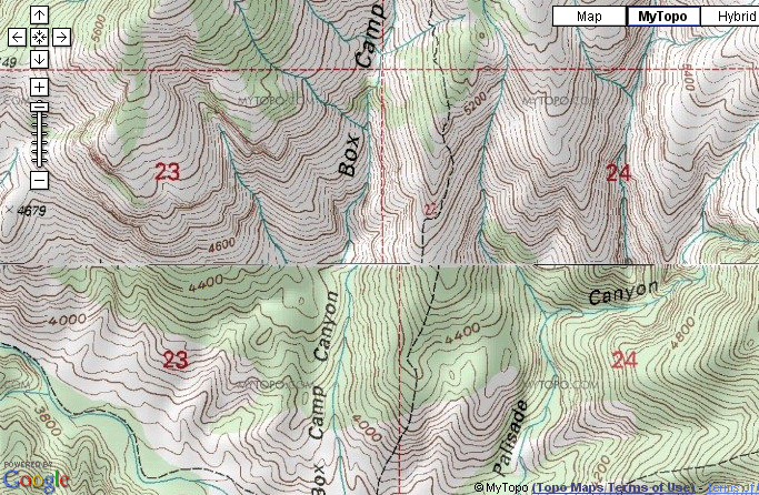
Just want to make sure the OP understands that you can do high resolution exports (4000x4000 or maybe 8000x8000) as a single image, but, yes, you need to pan/zoom TF to cover the area you want.  You'll get significantly more resolution than what is shown, but it can be difficult to get a hang of at first, specifically when it comes to knowing which tileset you will get.

To me that's more intuitive than any interface I've thought of for exporting an area beyond the current screen view.  I suppose you could draw a box around the area you want, and then choose a specific tileset, similar to how the Garmin Custom Maps export works.  It's likely to create some huge image sizes, but now that the tiling is there for Custom Maps, maybe that isn't much an issue.  I will look into how large a jpeg I can create.  The size of the exported map using tiling is no longer limited by video hardware (specifically the maximum texture size your video card supports).

Thanks for the thoughts, as always, Ken.

968
TopoFusion Anouncements / Tutorial - Uploading TopoFusion maps to your GPS
« on: December 21, 2009, 10:35:41 AM »
There is a new tutorial that should help people getting started with uploading maps from TopoFusion to Oregon/Dakota/Colorado GPS units.  Or, help those already using it get the most out of the feature:

Find it here:

http://topofusion.com/garmin-custom-maps.php

969
TopoFusion Pro / Re: Network Settings
« on: December 21, 2009, 10:33:37 AM »
My best answer is.... that it depends!  :)

The biggest factor, I think, is the amount of error in your data.  If you have pretty good data you may be able to get away with smaller values.  Lots of noise?  Gotta crank it up to get what you want.

I generally find I need to use values a little higher than what the defaults are in the software.

Also, sometimes I prefer a more simple network, so I crank up the 'contraction' slider all the way, regardless of how accurate I think my GPS data is.

970
Feature Requests / Re: Save As KML
« on: December 19, 2009, 12:48:43 PM »
You got it.  For some reason I thought I already made the kml export work, but evidently not.  I'll make a note.  Should be an easy addition.

Thanks.

971
TopoFusion Pro / Re: Heart Rate - Garmin Oregon
« on: December 16, 2009, 11:23:32 PM »
Thanks for staying with it -- I will think about what could make it come up as active log.  There has to be something there.

Good point on the beta.

So you are getting the exact same data (coordinates, time, etc) but without the HR now?  Huh.

972
TopoFusion Pro / Re: Heart Rate - Garmin Oregon
« on: December 16, 2009, 08:38:43 PM »
Hmm, that is very strange indeed.  I always leave my tracklog on, too.  And mine seems to see / grab the HR data with it on.  I just downloaded tonight's night ride and it came up with a location as a path to the file, and saved to .TCX with the full HR data for the ride in tact.

I'll keep an eye out for it as I download more tracks.  Let me know if you learn anything more, too.

973
1) Update your firmware.  

2) With your GPS plugged into your computer, create a directory called "CustomMaps" in the "Garmin" sub directory on either your GPS itself, or the SD card.  Map images in the .KMZ (google earth tile) placed in either CustomMaps directory will be automatically loaded by the GPS.

3) Use TopoFusion -- it has the ability create large scale KMZ files from any of the available imagery in the software.  That includes 24k topos and high res color aerials for most of the country.  You can also add your own custom maps to TopoFusion and upload those.  Just use the "File->Export View" command to get started.

4) Use the custom maps feature to upload tracks, too.  Anything that is displayed in TopoFusion gets rendered and put into the custom map.  That means you can have hundreds of GPX tracks loaded and they will all show up on the GPS.  No more simplifying and splitting of tracks, worrying about whether it'll all fit or not.  

I have found this to be extremely useful.  I can load up (or draw) several tracks in an area, change their colors/widths, and then get them all very easily onto my GPS, laid over a highly detailed basemap.  

This is hands down the best way to get a GPS network onto a GPS for use in the field.

5) Use Topo 4M.  I've found that the white background on Topo 4M makes the map more readable than the Garmin vector basemap (e.g. Topo 2008 DVD).

In addition I recommend 4M to cover more area (than Topo 2M) and also so that tracks you have loaded end up thicker and easier to see.  You may want to add additional thickness to your tracks by right clicking on them in the map and choosing "Track Properties."

6) Aerial photographs are cool, but harder to see.  I definitely get a kick out of passing a big building and seeing what it looks like from the top, but aerials tend to be a little dark and tough to read outside on the Dakota and Oregon screens.

7) Remember that you can only have 100 map tiles on your GPS at a time.  TF will give you a warning message if you generate a single KMZ file with more than 100 tiles (the number is displayed as you zoom in and out and choose a tileset as well).  But even across multiple KMZ files you can only have 100 tiles total.  So, be careful.

8 ) You can use Google Earth to preview the generated KMZ file and see what you have.  It will look less pixelated on the GPS since Google Earth resamples the map tiles and loses some quality.  Still useful to verify what you have.

974
TopoFusion Pro / Re: Heart Rate - Garmin Oregon
« on: December 16, 2009, 03:45:03 PM »
If there's HR data in the track you are selected (it's OK if the location has them as files -- that's where TF gets the data) it should prompt you to save it as a TCX.

For some reason it isn't seeing it.  Are you sure the track you are picking actually has HR data and isn't another track without it?

Otherwise, maybe send me the Current.gpx file.  I can mock up a fake USB storage and test it on my end.

975
GPS, Trails, Training / Dakota 20 Review
« on: December 16, 2009, 03:42:58 PM »
I posted a fairly lengthy review of the Dakota 20 on my blog:

http://www.topofusion.com/diary/2009/12/16/garmin-dakota-20-review/

976
TopoFusion Pro / Re: Heart Rate - Garmin Oregon
« on: December 15, 2009, 07:21:17 PM »
Hmm, I just tried it on my Dakota, and all seemed well.  In the merge/delete tracks dialog did it ask you to save as a TCX file?  That is the default when part of the track has HR or CAD data.

Somehow the HR data is getting stripped in there for an Oregon, I guess.  I'm not coming up with anything that could be different, but I'll keep thinking.  I'm pretty sure you have a recent version of TF, probably very recent.

Hmm.

977
TopoFusion Pro / Re: Heart Rate - Garmin Oregon
« on: December 15, 2009, 04:56:39 PM »
What about the GPX on the unit itself?  Look for Current.gpx in Garmin/GPX or maybe Garmin/GPX/Current

978
TopoFusion Pro / Re: Heart Rate - Garmin Oregon
« on: December 15, 2009, 04:43:34 PM »
No tricks that I know of -- the data should be there in the GPX file.  Have a look at the GPX and double check that it is there (it should be pretty obvious, the string surrounding the data is quite long).

Are you using TF to download the track?  It's possible it's getting lost in that saving process.  Maybe check the GPX on the unit itself for HR values.  I will test with my Dakota and HR strap on my next couple rides.

979
Feature Requests / Re: User Maps and importing from OziExplorer
« on: December 14, 2009, 01:53:55 PM »
That is a bit of a strange looking file format, but OZI is well used, so is definitely under consideration for usage in User Maps.  We definitely plan to implement some automatic ways of getting user maps with calibration into the software (e.g. world files). 

Thanks for the suggestion.

980
Feature Requests / Re: Rotate a user map?
« on: December 14, 2009, 01:51:45 PM »
TF can rotate, skew and shear any user map.  The 3 point transform allows for this.  Just calibrate three points and you should get the whole thing rotated to line up.

You can't manually change the rotation, but the computation for it is definitely there.  Give it a try and let me know if it works for you.

981
Feature Requests / Re: Shading for elevation
« on: December 14, 2009, 01:49:35 PM »
Hmm, good idea.

982
Feature Requests / Re: Feature Request - APRS integration
« on: December 14, 2009, 01:48:47 PM »
I would still love to have this functionality in TF, but have not been able to decipher the basics of the protocol.  It should not be so hard, but it's very complicated.

I will have another look, though.

983
Feature Requests / Re: Zoom recenters on mouse cursor
« on: December 14, 2009, 01:46:57 PM »
+ and - are zoom in/out, but only if you have a num pad.  On laptops I recommend using pgup / pgdown.  I think you are right that the - and = could be zoom in/out, rather than brightness.

A mode for re-centering zoom seems like a reasonable idea.  I'll put it on the list.

984
TopoFusion Pro / Re: Problem with 3D
« on: December 14, 2009, 01:41:57 PM »
Check out the 3D settings in TF.  Crank both the texture and model size down and see if that gets it back.  Sounds like the surface may be too big, and turning the texture multiplier down should do the trick.

Otherwise, check the diagnostic file (there's a link to it in the start menu group now) for any directX errors.  Might be some clues there.

Let me know how it goes.

985
TopoFusion Pro / Re: Replay of merged tracks
« on: December 14, 2009, 01:40:13 PM »
Hey Steve--

Not sure about EveryTrail reporting a zero length track.  Most likely it's a problem on their side as you suggest.  Perhaps they simply don't account for tracks that span multiple days?

As for replaying a track like this, this is definitely a planned addition to the playback (and/or multi-playback) tool.  It'll be a "skip stopped time" option, so you can, for example, compare two tracks without stops messing up the comparison.

It'll work great for skipping overnights -- I have the same issue with all my bikepacking GPX files.  Have to ramp up the playback speed, then crank it back down once day breaks...

986
TopoFusion Pro / Re: USER WMS
« on: December 07, 2009, 11:36:00 AM »
Hi,

One reason you are getting maps is that you aren't selecting any map layers to display.  If you do a get capabilities request, it'll return this:

http://ims.cr.usgs.gov/WMS_Capabilities/USGS_EDC_Ortho_StateLocal/capabilities_1_3_0.xml

You can see a number of layers there, so you would then need to add some of the <name> elements of the layers you want to the 'request' string.  Eg:

wmsconnector/com.esri.wms.Esrimap/USGS_EDC_Ortho_StateLocal?Layers=CA_LosAngelesCounty_0.3048m_Color_Jan_2006_2&CA_LosAngelesCounty_0.3048m_Color_Jan_2006_1&CA_SanDiegoCounty_0.3048m_Color_Jan_2006_1&VERSION=1.1.1&FORMAT=image/jpeg

The server also needed a version parameter and an image format type.  However, right now it is giving 'service unavailable' and other errors that don't have anything to do with the request string.  Hopefully it'll start working, maybe by the time you add the request string above and give it a shot.

Let us know how it goes.  I really hope to make this easier (e.g. selecting from available layers) in the future.

Thanks.

987
Feature Requests / Re: KMZ Tiling of User Maps
« on: December 01, 2009, 01:33:29 PM »
Steve-

The tiling does work with user maps, too.  The tiled export won't be specific to the user map (1:1), but if you choose a base tileset like topo 4 or topo 2, you should get full detail on your user map (unless it is very small scale, in which case you could try Color .0003 or even Urban 0.25).  Just zoom the current view to show the entire thing and make sure it's visible (enabled).

Let me know how it works for you.

988
Feature Requests / Re: Place Names
« on: December 01, 2009, 01:14:39 PM »
These are good thoughts, and I agree it's be nice to have an easy way to zoom around to your favorite 'hot spots'.  Also place names would be handy.

989
Feature Requests / Re: Split Track enhancement
« on: December 01, 2009, 01:13:19 PM »
Hi,

1.  The simplify function in TF is very good at preserving detail and minimizing points.  Have you tried it?  Why do legs need to be 20-25 miles long, just curious?

2.  Are you trying to upload as saved tracks or to the active log?  If the former, the name is not important -- you get 20 x 500 points no matter what.  If using the active log, you can have as many track segments as you want, with 10,000 points total, and the unit drops the name no matter what it is.  Maybe you can explain more why it needs to be named a specific way?  I have a lot of experience uploading tracks to that unit and I must be missing something.

Thanks.

990
TopoFusion Pro / Re: Public WMS
« on: December 01, 2009, 01:09:23 PM »
That is a list of many WMS services, most of which will work with TF.  Each one would need to be set up and configured separately, though.

I plan to make the configuration process a lot easier in the next version of TF.  There are a few quirks to it right now, but is certainly possible to get servers up and running.  Use the connection strings for the WMS servers that come pre-configured in TF to get started, or feel free to ask questions.  What servers in particular are you looking to try out?

991
TopoFusion Pro / Re: User Maps in 3.95
« on: December 01, 2009, 01:06:08 PM »
Excellent, thanks for getting back to us on that.

992
Feature Requests / Re: SPOT/ Chase vehicle support
« on: November 28, 2009, 08:59:42 PM »
Have you seen trackleaders.com?  It is our other site for live SPOT tracking software.

We do plan to add live tracking features into the TF application itself, sometime in the near future.

Thanks for the suggestion/interest.

993
TopoFusion Pro / Re: How to Save Merged Files
« on: November 28, 2009, 08:46:32 PM »
Are you using v3.95?  'save as..' doesn't merge, but there is an option available when multiple files are selected (meaning highlighted, not checked).  If you shift or control click multiple files, then right click and choose "merge files and save as..." you'll get what you are looking for.

994
User Projects / Re: GPS Playback + Helmet cam footage
« on: November 28, 2009, 08:36:18 PM »
Using a free program called CamStudio.

995
TopoFusion Pro / Re: Support for Garmin Forerunner 405
« on: November 28, 2009, 08:23:13 PM »
No, there is no direct support for units that use the ANT stick.  Here is another topic that talks about how to get the TCX files from Training Center and open them up in TF:

http://www.topofusion.com/forum/index.php?topic=3994.0

996
You are correct, there is a 100 tile limit for the entire GPS.  Hopefully that limit is either increased or a method of turning on/off maps is introduced.

997
TopoFusion Pro / Re: How to turn on Mexico maps?
« on: November 26, 2009, 10:15:36 AM »
In 3.95 they are no longer 'on' by default.  Go to Windows->WMS Custom Servers and turn the checkbox next to "Mexico" on.  They should then show up in the tileset selector.

998
TopoFusion Pro / Re: zoom box ? Why so weird ?
« on: November 26, 2009, 10:14:12 AM »
I guess there are some advantages of the other method, I really haven't thought too much about it since implementing the zoom box some years ago.

The problem with choosing two corners is the aspect ratio of the TF window will not be the same, so you will never get exactly what you click on (I think most programs simply give you more than what you covered).

TF's zoom box stays the same as the aspect ratio of the window, but I suppose it is a non-standard way of doing it.  Anyone like it better?

An option for both would make sense.

In the meantime, try holding down CTRL and using the +/- (or pgup/pgdown) keys.  With CTRL down you get a very subtle change in zoom level -- very handy for getting what you want out of the export feature.

Thanks for the suggestion.

999
Feature Requests / Re: Smooth Drawing Tools (plus better route management)
« on: November 23, 2009, 07:04:39 PM »
First -- regarding drawing tools.  Try holding down the mouse button while you draw.  This gives continuous drawing similar to what you are describing in Topo!.  I like having both since it is can be hard to trace a straight section of road or trail using free hand drawing.  In TF you can combine the two during a single track trace.

Also, I recommend using the arrow keys to pan the map when you get to the edge.  Also, if you hold down the CTRL key, the tool mode turns to pan mode until CTRL is released.  That's a VERY handy tip and works for all tool modes.

If I parsed your routing suggestion correctly, I think you can do what you want using networks in TopoFusion.  If you already had trail data already you could combine your tracks, then create hypothetical routes (complete with a profile and stats) using the "merge tool."  You just click segments of the network in succession (right click to get a menu with more options).  Creating a network slices up tracks into distinct pieces, eliminating duplicate representations of a single trail.

Now, if you were creating a network from scratch (by drawing), I would just draw each segment (from trailhead A to the first intersection with any other trail).  Save out each segment as a different track (with no overlap among the tracks).  Now you have all your pieces.  Use the merge tool to put them together (it will auto reverse things as you click, so don't worry about direction -- although you do need to make sure your first segment is in the direction you want).

Hopefully that makes sense, or let me know if you're trying to do something different.

1000
TopoFusion Pro / Re: Garmin KMZ Support
« on: November 23, 2009, 06:55:39 PM »
BTW, for the context of this thread, multi-tile support is there, as of version 3.95.  It is much more clear as to what map you are getting -- you simply select the map you want and the software tells you how many 1000x1000 tiles it takes to cover the current view.  Hopefully it makes sense.

urgar2002 -- I will have a review of the Dakota sometime soon.  The screen visibility is definitely an issue, but not enough that it's unusable on the handlebars.  I do very long races on the bike and when it really matters (saving time) I don't think I'd use the Dakota.  But for exploratory day rides the custom maps feature is VERY handy, and especially topo maps uploaded from TopoFusion seem to be quite visible on the screen.

Stay tuned for more...

Pages: 1 ... 18 19 [20] 21 22 ... 32