TopoFusion.com

Archive for the ‘Uncategorized’ Category

High Res 3D

Tuesday, March 18th, 2008

Previous versions of TF could only export a 3D view limited by the resolution of your monitor. Now with version 3.31+ you can arbitrarily set the size of the export – up to 8192×8192 on recent video cards!

Here is a (large) example of a high res export from the Wasatch Mountains. This will appear in the next issue of BIKE magazine. It shows the route of a five day singletrack trip.

(Warning – large file – 2.5 mb jpg)

The Landsat tiles are really great for large scale 3D views like this. Google Earth has some great high res imagery, but you get a nasty “patchwork” effect when you try to look at too much terrain at one time. Landsat is very consistent.

Also check out the “Texture Detail” setting, new in v3.31. This greatly improves the quality of 3D views in TF.

1100 unsupported miles across Alaska

Sunday, February 24th, 2008

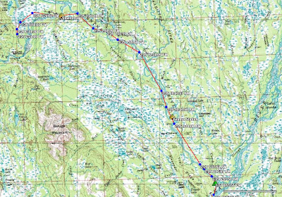
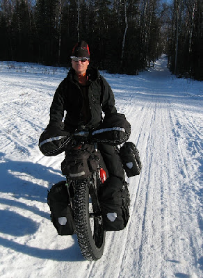
Adventure cyclist Mike Curiak asked us here at TopoFusion to help track his latest journey. He already holds the human powered world record for the Iditarod trail. Now he’s going back and trying to ride the whole thing completely unsupported. That means he’s carrying all the food, water, gear and muscle needed to travel all 1,100 miles to Nome.

Racers in the Iditarod Trail Invitational (who travel the trail by bike, foot and ski) have the “luxury” of staying in various lodges and checkpoints along the way. They pick up drop bags, buy food and perhaps most importantly, warm up! But Mike will be forgoing all that, testing the limits of what has been done with human powered winter travel.

He is carrying a findmespot beacon, which (if all goes well) will send a breadcrumb point every 10 minutes. We’ll be able to load these points (Spot’s site exports GPX files) in TopoFusion and view his progress. We’ll also be able to do things like track playback and speed computations.

Head on over to Mike’s blog to get the latest update on his progress, using TopoFusion software:

lacemine29.blogspot.com

Pro Version 3.23 Released!

Wednesday, February 20th, 2008

Version 3.23 was released today.

Major changes:

* Due to a change in the server, version 3.20 can no longer download Canadian Topos. The latest release fixes this.

* Extensive support for Edge/Forerunner units:

– downloading HR/Cadence data
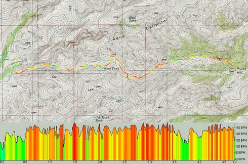
– profiling HR/Cadence
– track shading by HR/Cadence
– save/load files in .TCX/.CRS
– upload tracks as “Courses”

Example of Heart Rate shading with corresponding HR profile:

* More FUSION in your TopoFusion. You can now choose the tilesets you wish to combine in combo mode. Examples include tiger/aerial, urban/aerial, urban/topo, etc. Look for the tileset dropdowns in the Image Processing dialog.

Example combo Urban/Tiger tilesets:

* Smart merging of tracks – less use of the “reverse last segment” feature.

* The profiler in general got a makeover and is now more useful.

* Check out the “moving intervals” analysis in the Lap Analysis menu. I’ve been having fun placing waypoints labeled with the amount of time spent stopped on my GPS tracks. The results are sometimes quite surprising!

* many smaller additions, tweaks and general improvements.

Full the revision list

Profiling the Appalachian Trail

Sunday, January 20th, 2008

AT profile

At over 2100 miles, the Appalachian Trail pretty much defines the word “epic.” The original thru-hiking trail, it attracts thousands of adventure seekers each year.

TopoFusion was approached to undertake the difficult task of profiling the entire AT. We didn’t have to hike the entire trail, but there was quite a bit of data processing and extension of the software. All fun stuff as long trails like this really capture our interest and imagination.

The result is above — the entire AT profiled to high detail. According to Climbing Analysis, there’s over 500,000 feet of climbing on the trail. Think about that number for a while. That’s a lot of vertical.

Anywho, the profiles can be seen in the latest and greatest hiker’s handbook to the trail, Appalachian Pages by David Miller. The profile lines are watermarked vertically behind the mileage cues and narrative, giving a very handy reference while out on the trail. Check it out.

App. Pages cover

We’ve made the AT GPS data available for download from TopoFusion. This includes GPX and KML files for both the entire trail and all the shelters. Head over to:

Appalachian Trail GPS Page

New map servers in TopoFusion!

Wednesday, January 9th, 2008

TopoFusion Pro version 3.20 was released today.

Two new map servers have been added to the available imagery in TopoFusion:

1 – Canadian Topo Maps

ctopo

2 – TIGER street data for the United States

These two image types come from different map servers, separate from both Terraserver and OnEarth.  The future is looking bright for public domain, public access map servers!


For other additions see the revision history:

http://topofusion.com/revhistory.php

We also put together a fun page showing the history of the TF splash screen:

http://topofusion.com/splash.php

For registered users, remember that you can get both your name/code and the download URL by requesting an automated “lost code” from:

http://topofusion.com/lostcode.php

(Recall that the demo version cannot be registered)