Show Posts

This section allows you to view all posts made by this member. Note that you can only see posts made in areas you currently have access to.


Topics - Krein

Pages: [1] 2
1
GPS, Trails, Training / Free Topo Basemaps - 40' contours!
« on: May 01, 2008, 12:08:55 PM »
A number of independent  developers are piecing together high resolution DEM data and GIS layers to form their own statewide Mapsource maps.  They are free, though I suggest donating some money for their hard work.

Here's AZ:

http://www.gpsfiledepot.com/maps/view/1/

note: currently the roads in Pima county are off.  I've already contacted the devs to see if they think it's easily fixed

And CO, MT, UT, WY:

http://www.miscjunk.org/mj/mp_main.html

I don't yet have much experience with these in the field, but they look great in Mapsource and on the unit itself.

2
In the current version of TopoFusion Basic (2.971) there is a problem loading the global, Landsat tiles.  These come from Nasa'a OnEarth server, and they recently implemented some server changes that block the way TF Basic accesses the images.  Unfortunately there isn't much we can do about this.

TF Pro is not affected.  We suggest you upgrade to Pro if you need Landsat images.


3
TopoFusion Anouncements / Terraserver OK
« on: May 01, 2008, 09:40:37 AM »
Terraserver is still serving tiles, but is much slower than usual as of this morning.

You may get a "error connecting to terraserver" message from TopoFusion if the delay is too long.  Try re-enabling downloading if this happens.

It should be back to normal shortly.

4
Beta Testing / Beta v3.34
« on: April 28, 2008, 06:18:25 PM »


Version 3.34 is out in the usual place.  Changes:

3.34 - [4/28/08] (Beta)

Added "Garmin Astro" tracking to live tracking.  Continuously
   downloads tracks from the GPS.
Uploaded saved tracks now preserve track name (if present)
Downloaded saved tracks names now preserved
Track name now shown in profile window, if existing
Added "Add file to Logbook" to right click file menu
Fixed average cadence computations to not include coasting
Fixed missing baud rate with Magellan units in GPS Transfer dialog
Removed NMEA tracking debug info

---------------------------

Astro live tracking was added by request.  Find it in GPS->Live Tracking.  For "GPS Type" choose "Garmin Astro." Then hit "Start Tracking."

Basically this function continuously downloads tracks and shows the most recent result in the map window.  In other words, this will work on any Garmin USB unit, but it's designed with the Astro in mind since each dog track shows up as a saved tracks.

The "center map on position" toggle will zoom the map to fit the *first* track downloaded, after an download is complete.  It may or may not be useful--let me know.

The map will automatically redraw when a download is complete, but the display will be a little funky if you pan/zoom the map during a download. You'll get it "in progress" rather than the most updated positions.

------

We're still working on better support for multi-track files, especially with names.  Also, disambiguating clicks when there are (say) multiple tracks in the same area.


5
TopoFusion Pro / Note to Edge 205/305 users (Forerunner too)
« on: April 16, 2008, 02:56:21 PM »
Please note that if you experience trouble with the interplay between TopoFusion and Training Center, we highly recommend updating to the latest Training Center.

You can do so here:

http://www8.garmin.com/support/download_details.jsp?id=835

Example problems caused by old version of Training Center):

Claiming Invalid CRS file upon open (saved by TopoFusion)
Can't input .TCX files (only .HST)
Trouble syncing with Edge after uploading a course in TopoFusion

All these are resolved in the latest version of Training Center.

6
TopoFusion Anouncements / V3.32 out - minor revision
« on: April 10, 2008, 09:26:56 AM »
Hi all,

We released a minor revision of TopoFusion Pro today.  It clears up a few issues that have arisen since V3.31 which is otherwise quite stable.

Details:

3.32 - [4/9/08] (Full Release)

Fixed power .CSV import for iBike exports (no torque info)
Fixed possible crash with “interpolate GPS at 1 sec intervals” function
Fixed min/max computation for grade (was setting cut-off based on average
    uphill grade and average downhill grade)
Weakened grade and speed smoothing in profiler (smoothing options to come)
Fixed added waypoint fields in Lap Analysis (were always coming out as
   “stopped time” style waypoints)
Changed Saved Tracks to display “No time” instead of “Dec 31, 1989”
Added distance field to CSV exports (for RaceDay)

7
Beta Testing / Thanks beta testers!
« on: March 19, 2008, 03:19:35 PM »
Just wanted to give a shout out to our strong core group of beta testers.  You guys really help move TF along, and especially make sure things are running smoothly.

V3.31 (full public release, out now) supercedes the current beta, with a few minor fixes.


8
TopoFusion Anouncements / V3.31 Released!  Power, 3D textures
« on: March 19, 2008, 11:44:09 AM »
We are happy to announce the release of version 3.31 of TopoFusion PRO.

Download the latest demo version:

TopoFusion Pro v3.31 Free/Demo

Or, registered users refer to their registration email for download instructions.  If you've lost the download URL or your name/code, you can request it here:

http://topofusion.com/lostcode.php


9
Beta Testing / 3.26 - Power in TopoFusion
« on: March 10, 2008, 07:50:17 PM »
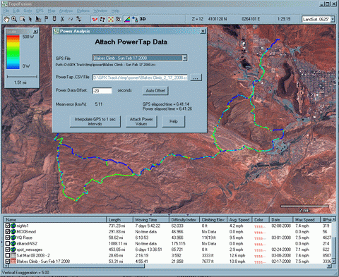
The latest version of TF supports the Edge 705, including power enabled TCX files.

For more info on the power related features in TopoFusion, go to:

http://www.topofusion.com/power.php


This is pretty exciting stuff since mapping power output really hasn't been done before.  The Edge 705 is going to make some of this easier, but even the newest PowerTap hubs won't be supported with the 705, so the "attach PowerTap data" function should be quite useful for some time.

More power features are planned (peak power intervals, BikeScore, etc!).

10
Beta Testing / New 3D stuff - 3.25/3.26
« on: March 10, 2008, 07:49:24 PM »


A new setting in 3D settings is available: Texture Detail.

Basically this increases the size of your current map view so that you have a higher resolution map painted on the 3D model.  This is especially useful when you zoom in on the model, or as you explore the terrain.

As you move the slider the texture will update itself.  Note that the tileset will change according to your tileset settings.  So you may get a higher resolution tileset than currently in 2D view.  This is a good thing, though if you want to keep your tileset and exact view, you can always leave the Texture setting at 1.0.

The only downside is a brief pause while generating a 3D view.  So you can go as high as you're willing to pay in terms of waiting.  Also note that the size of the map is limited by your video card's maximum texture size, so it may not get much more detailed beyond a certain point (depending on video hardware).

Overall, this is a major improvement in the quality of 3D views.  I've been having a blast looking through old GPS files and re-exploring areas in 3d mode.

High res 3d exports

Previous versions of TF could only export the current 3D view.  Now you can arbitrarily set the size of the export - up to 4096x4096 on most cards (8192x8192 on newer ones!).

Here is a (large) example of a high res export from the Wasatch Mountains.  This will appear in the next issue of BIKE magazine.  

Wasatch 5 day trip

The Landsat tiles are really great for large scale 3D views like this.  Google Earth has some great high res imagery, but you get a nasty "patchwork" effect when you try to look at too much terrain at one time.  Landsat is very consistent.

11
TopoFusion Anouncements / Pro Version 3.23 Out!
« on: February 20, 2008, 05:14:59 PM »
Version 3.23 was released today.

Major changes:

* Due to a change in the server, version 3.20 can no longer download Canadian Topos.  The latest release fixes this.

* Extensive support for Edge/Forerunner units:

  - downloading HR/Cadence data
  - profiling HR/Cadence
  - track shading by HR/Cadence
  - save/load files in .TCX/.CRS
  - upload tracks as "Courses"

Example of Heart Rate shading with corresponding HR profile:
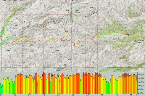


* More FUSION in your TopoFusion.  You can now choose the tilesets you wish to combine in combo mode.  Examples include tiger/aerial, urban/aerial, urban/topo, etc.  Look for the tileset dropdowns in the Image Processing dialog.

Example combo Urban/Tiger tilesets:


* Smart merging of tracks - less use of the "reverse last segment" feature.

* The profiler in general got a makeover and is now more useful.

* Check out the "moving intervals" analysis in the Lap Analysis menu.  I've been having fun placing waypoints labeled with the amount of time spent stopped on my GPS tracks.  The results are sometimes quite surprising!

* many smaller additions, tweaks and general improvements.

From the revision list:

3.23 - [2/20/08]  (Full Release)

Fixed error connecting to Canadian Topo Server
Added Heart Rate/Cadence downloading for Edge/Forerunner units
Added Garmin .CRS/.TCX import (necessary to store HR/Cadence data)
Added ability to upload tracks as "Courses" to Edge/Forerunner units
Added new track shading options: Heart Rate, Cadence and Power
  - faster access to shading type in the "Map->Track Shading" menu
Added new statistics and "y-axis" options to profile window
  - including moving time, HR, Cadence, Power
  - Climbing/Descending stats now match main TF window
Added "Moving intervals" analysis type to Lap Analysis dialog
  - Use to place waypoints at each "stop" on a GPS track
Added "Export to Raceday" button to Run Analysis - exports running power
    data to Physfarm's Raceday software
Added "Place Waypoint" button to Goto Coordinate dialog
Forced waypoint dialog to stay open after invalid coordinate entry
Fixed bug with zero elevation in NMEA live tracking
Fixed bug when exporting 3D screenshots with "add profile" checked
Improved clipping/drawing speed for photo icons
Added warning message when uploading tracks that are too large
Fixed GPS dialog to keep file choice when choosing between options
Fixed problem with highlighted track point from file props not showing up
Fixed bug causing waypoints to disappear after editing
Fixed some minor profile details - stats, low heart rates, crosshair tracking
Fixed bogus name field in CRS/TCX files

3.21 - [1/28/08]  (Beta)

Added ability to change tilesets used in combo mode
  (eg: TIGER/Aerial, Urban/Topo, Urban/Aerial now possible)
Added "smart" merging (track merge tool)
  - also: holding shift is no longer required to merge
Added export of Garmin Course files (.CRS)
Forced onscreen message OFF when exporting
Added "open containing folder" button to export view dialog
Added true north azimuth output to track drawing tool
Added settings for UTM grid line width and opacity
Added setting for waypoint symbol size
Fixed problem with stray point added to end of drawn track
Improved interplay between other graphic intensive software (e.g. GE)
Fixed issues with D3D_OUT_OF_MEMORY errors

12
TopoFusion Anouncements / Server Issue - Canadian Topos
« on: February 14, 2008, 08:05:16 PM »
Version 3.20 of TopoFusion is experiencing trouble connecting to the Canadian Topo map server.  We are have a fix and are testing it in the latest beta.  We should have Version 3.22, with the fix, released within the next few days.

Thanks for the patience.  Until then you will get a "cannot connect to server" message when trying to download Canadian maps.

All other tilesets and map servers are up and functioning great.

13
Beta Testing / Heart Rate, Cadence - v3.22 Beta
« on: February 14, 2008, 07:51:46 PM »
Version 3.22 is now out:


There's a screenshot of a track with "Heart Rate Shading" turned on.  Also the profile is graphing Heart Rate.  

Quite a bit new in this version.  From the revision list:

3.22 - [2/14/08]

Fixed error connecting to Canadian Topo Server
Added Heart Rate/Cadence downloading for Edge/Forerunner units
Added Garmin .CRS/.TCX import (necessary to store HR/Cadence data)
Added ability to upload tracks as "Courses" to Edge/Forerunner units
Added new track shading options: Heart Rate, Cadence and Power
  - faster access to shading type in the "Map->Track Shading" menu
Added new statistics and "y-axis" options to profile window
  - including moving time, HR, Cadence, Power
  - Climbing/Descending stats now match main TF window
Added "Moving intervals" analysis type to Lap Analysis dialog
  - Use to place waypoints at each "stop" on a GPS track
Added "Export to Raceday" button to Run Analysis - exports running power
    data to Physfarm's Raceday software
Added "Place Waypoint" button to Goto Coordinate dialog
Forced waypoint dialog to stay open after invalid coordinate entry
Fixed bug with zero elevation in NMEA live tracking
Fixed bug when exporting 3D screenshots with "add profile" checked
Improved clipping/drawing speed for photo icons
Added warning message when uploading tracks that are too large
Fixed GPS dialog to keep file choice when choosing between options
Fixed problem with highlighted track point from file props not showing up
Fixed bug causing waypoints to disappear after editing

*--------------------------------------------*

As usual, it's available here for registered users:

http://topofusion.com/beta.php


It looks like we'll have a quick turn-around to a full release due to the (just discovered) problem downloading Canadian Topo maps.  So, if you can, give it a bit of testing.

There's quite a bit to explain, but a few notes:

* If you download data from an Edge or Forerunner (and it has HR or Cadence data) TF will prompt you to save in .TCX rather than .GPX.  This is because there is no standard way to store that data in GPX.  TCX is very similar, and used by Training Center, Sporttracks, Motionbased, etc.

* There's not much difference betweent CRS and TCX files, so either are fine and both can store HR/Cadence.  The only difference, really, will be in how Training Center stores them once you upload.

* CRS and TCX files get different icons (rather than the standard globe that GPX files get) so you can tell which files are stored in those formats and can contain HR and Cadence data.

* Shading by power and also plotting (running) power in the profile window can only be done once you've done a "run analysis" on a run.  Then each point has power and these functions become available.  We're going to be developing this more in the future, esp. when Garmin units store power themselves.

* Finally the climbing numbers in the profile window match the main window!  This is because the profiler now won't count elevation that is gained when not "moving."  The addition of moving and stopped time is a great feature, too.  With larger files you should notice a speed up in the display of stats while you move the mouse over.

14
Beta Testing / Beta v3.21 - more fusion in your TopoFusion
« on: January 28, 2008, 01:39:11 PM »
Beta version 3.21 is out and available in the usual place:

Beta download page

New this time around is more options for the combo tilesets.  You can choose any of Topo/Aerial/TIGER/Urban to combo with anything else (if you choose the same for both the result isn't very interesting!).

Here's an example with Urban and Tiger in Tucson:


There are quite a few interesting combinations possible now.

Other additions/fixes:

3.21 – [1/28/08]

Added ability to change tilesets used in combo mode
  (eg: TIGER/Aerial, Urban/Topo, Urban/Aerial now possible)
Added “smart” merging (track merge tool)
  - also: holding shift is no longer required to merge
Added export of Garmin Course files (.CRS)
Forced onscreen message OFF when exporting
Added “open containing folder” button to export view dialog
Added true north azimuth output to track drawing tool
Added settings for UTM grid line width and opacity
Added setting for waypoint symbol size
Fixed problem with stray point added to end of drawn track
Improved interplay between other graphic intensive software (e.g. GE)
Fixed issues with D3D_OUT_OF_MEMORY errors


I can't believe we didn't have the "smart" merging until now - it only took a few lines of code, and it's so much easier to work with.  Basically it just does the reversing of tracks for you, based on distance from the current endpoint of the merged track to either end of the *just clicked on* track.  You can still right click and reverse should you want it the other way.

There are a few other long overdue minor things on there.  Hopefully the intended targets for some of those will be able to test them out.

Thanks.

15
TopoFusion Anouncements / v3.20 Released!
« on: January 09, 2008, 09:45:59 PM »
TopoFusion Pro version 3.20 was released today.

Two new map servers have been added to the available imagery in TopoFusion:

1 - Canadian Topo Maps
2 - TIGER street data for the United States

For other additions see the revision history:

http://topofusion.com/revhistory.php

We also put together a fun page showing the history of the TF splash screen:

http://topofusion.com/splash.php

For registered users, remember that you can get both your name/code and the download URL by requesting an automated "lost code" from:

http://topofusion.com/lostcode.php

(Recall that the demo version cannot be registered)

Thanks!

16
Beta Testing / New maps!  Beta 3.20
« on: December 30, 2007, 11:55:39 AM »
Beta v3.20 is out.  Here are examples of the two new map types added:

Canadian Topos:


Coverage is all of Canada, though I understand some areas may not have the highest (0.003 degrees per 512x512 tile) detail.  I haven't seen any of these areas, but I don't have a large collection of data up north either.

Regardless, these are pretty nice maps.  The server is a little slower than most of the other servers TF uses.  But for folks in CAN, this is a great addition.

TIGER


This sever is quite fast.  However, it is somewhat old (1998) census data.  In many cases the roads are more up-to-date than the USGS topo maps from Terraserver.  Still, these are not has high quality as, say, Google Maps or the like.  However, they are free, public domain (you can publish/sell maps with them), and I've already found them very useful for a few projects.

The coverage is US only, and you only get street names when zoomed in to the 4 meter tileset.  

I should also note that the projection on the maps is not perfect.  I had to do a few hacks to reproject the image, and it is not perfect.  You may notice some errors and misalignments between image tiles.  Some are unavoidable (the brown county boundaries, for example tend to go crazy).  But if you notice anything strange, especially roads not at all lining up, please post an example here with coordinates.

Like I said, they aren't perfect, but for free it's hard to complain.  A major benefit I've seen (besides getting street names) is for overview (large scale) maps.  The TIGER maps are much less "busy" than the topos.

There's good potential for doing combo maps with TIGER/aerial and TIGER/color aerial.  Also, CAN Topo and Landsat (both are in  geographic or lat/lon project, so they can be combined easily).  Look for more combo options in a future version.

As usual, errors, comments and suggestions post here or email us!

Thanks.

Change log:

3.20 – [12/30/07]  (Beta)

Added new Map Server: Tiger Line data for US
Added new Map Server: Topo Maps for Canada
  Find the new tilesets in the “Map” menu or the tileset dropdown
Major speedup in track drawing (clipping) esp. with large files
Fixed Lap Analysis exports for files with multiple tracks
Fixed problem adding elevation to files crossing UTM zones
Fixed splining GPS tracks across UTM zones
Made simplify dialog default to 500, or higher with large tracks

17
TopoFusion Anouncements / Holiday Sale - Ending!
« on: December 20, 2007, 12:18:10 PM »
For the first time in TopoFusion history, we're offering a sale.

For a limited time, take 15% off all licenses of TopoFusion Pro and TopoFusion Basic. Simply enter the coupon code SAVE15 on the second order screen. The next screen will confirm the 15% discout on your order total.

The 15% discount applies to all versions of TopoFusion and also to site licenses. But hurry, when the holidays are over, so is the sale!

New prices:

TopoFusion Pro - $59.46
TopoFusion Basic - $34.00


Head on over to the Purchase Page.

18
TopoFusion Anouncements / Pro Version 3.18 out
« on: November 05, 2007, 09:46:50 AM »
New version of TF Pro, with some big speedups and resolution of a few other issues.  From the revision history:


3.18 - [10/28/07] (Full Release)

Changed select points / zoom / select map rectangle to be more visible
Added Drag and Drop capability to active file list for GPX/supported files
Added "Open Containing Folder" option to right click on files
Added message when batch downloading across zones (not allowed)

3.17 - [10/6/07] (Beta)

Major speedup in track drawing
Major speedup when large numbers of waypoints are displayed
Added Lodging, Motel and Library to supported graphical symbols
(for Adventure Cycling data)
Fixed bug causing batch/box downloads to miss tiles when
   part of the download area was already downloaded
Fixed .kml export with special characters in filenames (& etc)

3.15 - [8/5/07]

Fixed Map toggle problem introduced in 3.14


19
TopoFusion Anouncements / Site issues
« on: October 25, 2007, 11:32:41 PM »
Sorry about the downtime folks.  Our entire site was unreachable due to a machine migration by our host.  It was supposed to be seamless, but obviously it didn't turn out that way.

Any emails sent to us on Wednesday 10/24 were not received - so please resend.  You likely got a "mail returned" email telling you this.

Things are back up and running, including, finally, the forum.

Good news is the new server is faster.  The forum seems to be responding quicker.

The entire automatic purchase system works perfectly.  It was the first thing tested, and besides testing, we've already had a successful purchase of TopoFusion Pro that went through without a hitch.

Thanks for the patience.

20
Beta Testing / 3.18 Beta
« on: October 15, 2007, 10:23:07 AM »
A few more additions in the latest beta:

3.18 – [10/15/07]

Changed select points / zoom / select map rectangle to be more visible
Added Drag and Drop capability to active file list for GPX/supported files
Added “Open Containing Folder” option to right click on files
Added message when batch downloading across zones (not allowed)

Unfortunately the drag and drop only works on the active file area (or the window title area of the main TF window) - NOT on the map itself.

"Open Containing Folder" just opens windows explorer with the current file selected.  I've already found this extremely useful since I have dozens of files open from all over my hard drive.

Thanks.

21
TopoFusion Anouncements / Elevation server back up
« on: October 11, 2007, 09:48:41 AM »
As of this morning, the elevation (Nasa) server is not serving up DEM data.  So 3D and adding elevation to tracks will not work.  Looks like it's not quite giving an error, so the 3D command just doesn't respond.  

After a few tries you will get an error about connecting to the server, however.

We'll continue to monitor this.  It's likely they'll come back soon, but if not we will contact the good folks at Nasa and see if they have an estimate.

Here is a page that shows images based on the DEM data.  When this page displays a B/W image, it'll be back up:

http://tinyurl.com/2k57fw

Thanks for the patience.

22
Beta Testing / 3.17 Beta out
« on: October 07, 2007, 09:17:00 AM »
The latest has some serious speed ups, and cleans up a few outstanding issues that really needed to be taken care of:


3.17 – [10/6/07]

Major speedup in track drawing
Major speedup when large numbers of waypoints are displayed
Added Lodging, Motel and Library to supported graphical symbols
(for Adventure Cycling data)
Fixed bug causing batch/box downloads to miss tiles when
   part of the download area was already downloaded
Fixed .kml export with special characters in filenames (& etc)


Both of the speedups won't be hugely noticeable unless you've got a fair number of tracks (or MANY waypoints) loaded.  There was a clipping problem on the track drawing so that even if you only were currently viewing one very small track, it would be as slow as if you were drawing all tracks you had loaded.

The waypoint thing is a bit different -- if there are too many waypoints on the screen TF will simply not draw them on every refresh.  So when panning or zooming, for instance, the text is just not shown.  GE and other programs do this as well -- drawing too much text is just too slow for real time map movement.  The effect can be a little annoying, but mega slow map refresh is much more annoying, trust me!

The load maps tool error was a pretty serious one - it was introduced in one of the more recent TF versions.  The gist is this - if you were downloading a totally new area, it works fine.  But if you already have part of that area downloaded, you would miss some new tiles in that area.  Definitely not cool - users need to be able to trust that the program has downloaded all (active) tiles within the download area once it says "finished."  That should be the case now.

As always, any comments or problems, post or email us.

Thanks.

23
TopoFusion Anouncements / Pro Version 3.12 Released
« on: July 02, 2007, 05:55:38 PM »
This was actually released over a week ago, but it was released just before a trip, so we never sent the announcement.

3.12 is a major improvement over previous versions of TopoFusion PRO.

Changes since the latest full release (v3.07) include:

3.12 - [6/21/07]  (Full release)

Fixed "automation error" when simplifying a track multiple times
Fixed bug popping up area calculation and edit track introduced in 3.11

3.11 - [6/15/07]  (Beta)

Added custom symbols.bmp and sprites.bmp ability
  (download and place in default tracks directory)
Added "Delete Track" to track right-click menu
Added all available GPX symbols to dropdown in waypoint dialog
Fixed intermittent "unknown exception" on finishing track download
Fixed multi-track playback in landsat tiles
Fixed multi-track playback "author" text label placement
Fixed some problems with deleted points and photos
Improved waypoint clipping
Fixed intermittent black squares in upper corners of map (since 3.03)
Increased opacity of photo thumbnails
Fixed pan/zoom between tracks in landsat
Fixed crash with D3D_OUT_OF_MEMORY at startup

3.1 - [6/6/07]  (Beta)

Added waypoint symbols!  (icons)
Added "split track" function to simplify/spline dialog
  --Used for splitting a large track into smaller chunks for
    for upload to a Garmin's "saved tracks"
Fixed some problems across zone boundaries
  Fixed scale bar in landsat tilesets
  UTM coordinate display now changes zones
  Fixed draw (pencil) distance in landsat
  Fixed dropping waypoints across zones
Improved .kml import (waypoints)
Added "Map" menu
  Allows switching to all map types without changing zoom level
  Also provides menu options for all map state toggles
  Reworked a few minor keyboard shortcuts
    Profile tool is now "F" key
    "O" key now switches directly to Combo Maps
Added "Make New Folder" button to Photofusion HTML directory chooser
Other Misc. fixes

3.09 - [5/31/07]  (Beta)

Added shapefile import
Improved .kml import
Added basic .kml export
Added GPS config dialog to GPS transfer dialog
Added confirmation dialog (y/n) to file renaming
Added purchase links to installer
Added "run TopoFusion" option to installer
Changed "no map" message for tiles outside UTM zone
Added "zoomed too far out" message

3.08 - [5/22/07]  (Beta)

Split profile/merge tool into two tools
  Profile now only profiles tracks
  Merge tool is used to join tracks
Added support for GT-3 USB GPS
Fixed possible crashes in NMEA live tracking
Fixed problem editing/selecting tracks/points when map
  display is disabled
Fixed problem reading UTM text files (from TopoUSA)
Fixed crash editing track properties

Head on over to

http://www.topofusion.com/download.php

To get the latest demo.  For registered users, refer to your registration email for the URL to download the full version.

Thanks!!!


24
Beta Testing / Version 3.11 out
« on: June 15, 2007, 07:57:46 PM »
3.11 – [6/15/07]

Added custom symbols.bmp and sprites.bmp ability
  (download and place in default tracks directory)
Added “Delete Track” to track right-click menu
Added all available GPX symbols to dropdown in waypoint dialog
Fixed intermittent “unknown exception” on finishing track download
Fixed multi-track playback in landsat tiles
Fixed multi-track playback “author” text label placement
Fixed some problems with deleted points and photos
Improved waypoint clipping
Fixed intermittent black squares in upper corners of map (since 3.03)
Increased opacity of photo thumbnails
Fixed pan/zoom between tracks in landsat
Fixed crash with D3D_OUT_OF_MEMORY at startup


To change the symbols or sprites in TopoFusion, first download the appropriate file:

http://www.topofusion.com/images/symbols.bmp


http://www.topofusion.com/images/sprites.bmp


If you place either of these files in your default tracks directory, TF will load them instead of the default files.  Of course everything maps to a particular portion of the files, so you need to be careful what you change, and need to stay within the current size.

Any bugs or issues, please let us know.

25
TopoFusion Anouncements / Nasa Server Upgrading
« on: June 12, 2007, 05:39:04 PM »
From Lucian at NASA's JPL:  (0n 6/12/07)

Quote

Just a warning:

We'll be updating apache on the server in the next few days, there might be problems.  Let me know if you see anything out of the ordinary, other than down/flaky service.


Please post here if you notice anything strange.  It sounds like any down times should be brief.

26
TopoFusion Anouncements / Nasa Server is up
« on: June 11, 2007, 04:09:53 PM »
Unfortunately, just on the heels of a Terraserver downtime, it seems that the Nasa server is experiencing some problems.  It has been down for the last hour or so.

Until the server is back up (you can check here for updates), TopoFusion won't be able to download Landsat maps or download elevations for 3D views.

Sorry about the downtimes.

27
Beta Testing / 3.1 Beta - symbols
« on: June 06, 2007, 04:01:42 PM »


!!


3.1 – [6/6/07]

Added waypoint symbols!  (icons)
Added “split track” function to simplify/spline dialog
  --Used for splitting a large track into smaller chunks for
    for upload to a Garmin’s “saved tracks”
Fixed some problems across zone boundaries
  Fixed scale bar in landsat tilesets
  UTM coordinate display now changes zones
  Fixed draw (pencil) distance in landsat
  Fixed dropping waypoints across zones
Improved .kml import (waypoints)
Added “Map” menu
  Allows switching to all map types without changing zoom level
  Also provides menu options for all map state toggles
  Reworked a few minor keyboard shortcuts
    Profile tool is now “F” key
    â€śO” key now switches directly to Combo Maps
Added “Make New Folder” button to Photofusion HTML directory chooser
Other Misc. fixes

28
TopoFusion Anouncements / Terraserver Back up
« on: June 01, 2007, 05:42:55 PM »
Looks like Terraserver is having some trouble this evening.  It was working earlier today.

It's responding, but often (always?) with white "fuzzy" tiles.  So if you are getting white tiles with "No map available for this location and tileset" written on them, it's not because there aren't maps.  There's just something wrong with the server.

We'll keep monitoring this and updating.

29
Beta Testing / Version 3.09 - More import/export options
« on: May 31, 2007, 12:08:54 PM »
3.09 just out.  Quickly:

3.09 – [5/30/07]

Added shapefile import
Improved .kml import
Added basic .kml export
Added GPS config dialog to GPS transfer dialog
Added confirmation dialog (y/n) to file renaming
Added purchase links to installer
Added “run TopoFusion” option to installer
Changed “no map” message for tiles outside UTM zone
Added “zoomed too far out” message


More details later....

30
Beta Testing / Version 3.08 - Some fixes
« on: May 22, 2007, 05:35:18 PM »
3.08 is available at the usual place.  Thanks for any testing.

3.08 - [5/22/07]

Split profile/merge tool into two tools
  Profile now only profiles tracks
  Merge tool is used to join tracks
Added support for GT-3 USB GPS
Fixed possible crashes in NMEA live tracking
Fixed problem editing/selecting tracks/points when map
  display is disabled
Fixed problem reading UTM text files (from TopoUSA)
Fixed crash editing track properties

31
TopoFusion Anouncements / Pro Version 3.05 Released
« on: May 02, 2007, 01:44:59 PM »
TopoFusion is pleased to announce the latest update of TopoFusion PRO.  This version cleans up many small issues in the v3.0 release, as well as adding new functionality and especially optimizations to the program.

Stay tuned for further development of TopoFusion Pro!  We have many new features on the drawing board.

TopoFusion PRO version 3.05

[5/2/2007]

Added "Use compressed DXT1 maps" to Options->Preferences
---> See forum (http://tinyurl.com/2mshq5) for details

(Major map display speedup)

Added ability to cancel a user map calibration point
Added DXT1 compression on user maps
Added airplane icon
Added PNG and JPEG export for profiles (from profile dialog)

Speedup - user maps loading using IJL instead of D3DX

Fixed crash when coming back from suspend/hibernate
Fixed delete/insert key not working at times

Fixed problems with TileSet dropdown synchronization
--disabled tilesets no longer show up
--now only 5 options in 3D mode: topo/aerial/urban/landsat/combo

Photofusion HTML now works both with thumbnail view and
  with camera icons (as before), depending on photo toggle state
Added "view Photo/URL" to right click menu for waypoints

Fixed memory leak on Topo 2/8/32 meter tilesets
Fixed problems with animated sprites
Increased maximum download threads to 25
GIS layers now has "..." button for choosing files
Fixed issue with tracks crossing zones in topo/aerial
Fixed batch download totals not updating
Fixed bug causing fuzzy networks and stray lat/lon points
Fixed bug causing hang with downloading disabled
Fixed runtime 13 error with logbook and international settings
Fixed issues renaming files in active list
Fixed problems reading GPX files from GPSies.com
Fixed stats icon - no longer photo
Added better lat/lon text reading -- AZ trail passage data
Fixed problem reading KML files introduced in 3.03
Fixed problem with UTM grids in datum other than WGS 84
Fixed 3D coordinate display in datum other than WGS 84

Download version 3.05 at:

http://www.topofusion.com/download.php

(registered users should refer to their registration instructions for the page to download the full version)

32
TopoFusion Basic / Basic Version 2.971 Released
« on: May 02, 2007, 01:42:17 PM »
TopoFusion is happy to announce a new revision of the Basic product.  This mainly features some bug fixes to an otherwise very stable and well-tested version of the software.

Look for more updates to TopoFusion Basic in the future.  We especially anticipate some user interface simpflicitation and clean up, bringing you an even more intuitive GPS experience.

TopoFusion Basic 2.971

Primarily a bug fix release
Fixed memory leak with Topo 2M/8M/32M tilesets
Fixed memory leak in 3D downloads
Updated code system
Added ability to record and save tracks in "Live Tracking" dialog
Fixed crash in paint layers

Download the demo/free version here:

http://www.topofusion.com/download.php

33
TopoFusion Anouncements / Basic Version 2.971 Released
« on: May 02, 2007, 01:42:17 PM »
TopoFusion is happy to announce a new revision of the Basic product.  This mainly features some bug fixes to an otherwise very stable and well-tested version of the software.

Look for more updates to TopoFusion Basic in the future.  We especially anticipate some user interface simpflicitation and clean up, bringing you an even more intuitive GPS experience.

TopoFusion Basic 2.971

Primarily a bug fix release
Fixed memory leak with Topo 2M/8M/32M tilesets
Fixed memory leak in 3D downloads
Updated code system
Added ability to record and save tracks in "Live Tracking" dialog
Fixed crash in paint layers

Download the demo/free version here:

http://www.topofusion.com/download.php

34
Beta Testing / Version 3.05 Beta
« on: April 09, 2007, 06:21:59 PM »
Any testing greatly appreciated!  We're hoping to do a full release this week.  Thanks!

More fixes and tweaks:

3.05 - [4/9/07]

Optimized getNewEasting w/o side-effects
Fixed delete/insert key not working at times
Fixed issues renaming files in active list
Fixed problems reading GPX files from GPSies.com
Fixed stats icon - no longer photo

http://www.topofusion.com/beta.php

35
Beta Testing / V3.04
« on: April 02, 2007, 11:33:40 AM »
Most of these are user requested, or initiated.  Overall, the program keeps getting better, small steps at a time.


3.04 - [4/2/07]

Fixed problems with TileSet dropdown synchronization
--disabled tilesets no longer show up
--now only 5 options in 3D mode: topo/aerial/urban/landsat/combo
Added PNG and JPEG export for profiles (from profile dialog)
Photofusion HTML now works both with thumbnail view and
  with camera icons (as before), depending on photo toggle state
Added "view Photo/URL" to right click menu for waypoints
Added better lat/lon text reading -- AZ trail passage data
Fixed problem reading KML files introduced in 3.03
Fixed problem with UTM grids in datum other than WGS 84
Fixed 3D coordinate display in datum other than WGS 84

36
Beta Testing / V3.03 - Texture compression
« on: March 28, 2007, 08:19:54 PM »
There's a new option in version v3.03 (out now on the usual beta page).  It's under Options->Preferences->General->Use texture (DXT1) compression.

The Good:

 * TopoFusion displays maps the way I've wanted it to since first writing it -- FAST.  The difference in loading map tiles from disk is quite large.  I'm getting load times that are about twice as fast.

* Memory usage.  TF is a bit of a memory hog if you have the tile cache set high.  Not anymore.  For the same size of cache (in terms of number of tiles cached) the memory usage is greatly reduced -- cut at least in half.

The Bad:

* Disk usage is a bit higher.  Tiles are stored in MapsX.dat files in DXT1 format, not JPEG.  The result is about 20% more disk usage.  This personally doesn't bother me, because disk space is cheap these days.  If I can find a better DXT1 encoder I should be able to reduce this to roughly the same space requirements in a future version.

* Loading previously downloaded JPEG tiles into a compressed (DXT1) graphics system is slower.  Basically this means your existing downloaded tiles will load about twice as slow as before.  Any newly downloaded tiles will be ripping fast, but old ones will be slower than before.

Texture compression defaults to "ON" (checked).  So, some of you may want to disable it if you have a large map files.

Edit - For users upgrading to v3.05 or later (the full release), the DXT1 option will default to "OFF".  Only brand new, fresh installs will default to "ON."  Regardless, you can always toggle it on / off later.

If there is enough interest, I will write a routine to convert map files downloaded before texture compression.  I'm OK with starting from scratch in order to get the speed/memory benefits, but others may have large map collections worth hanging on to.

Map files can be intermixed with DXT1 and JPEG tiles.  If the DXT1 option is checked when you download a map tile it will be saved in DXT1.  Otherwise it is saved as a JPEG, just as before.

v3.03 and up is able to handle both image types in the same map file.  There's just the difference in speed when converting JPEG to DXT1.  It will work perfectly fine, as before, if you turn texture compression off and stick with your existing map file.

I'm curious to hear any opinions on this.  Try it with a fresh map file (just change your map directory to an empty dir), and let me know what you think.  Clearly, for any new users, using DXT1 is the best choice.

Other changes in v3.03:

3.03 - [3/26/07-3/28/07]

Contrast/Brightness are back, not affecting entire display
Fixed crash when coming back from suspend/hibernate
Fixed memory leak on Topo 2/8/32 meter tilesets
Added "Use compressed DXT1 maps" to Options->Preferences
---> See forum for details
Fixed problems with animated sprites
Increased maximum download threads to 50
Fixed crash loading 2/8/32 tilesets in DXT1 mode
GIS layers now has "..." button for choosing files


37
TopoFusion Anouncements / Nasa Server Back Up
« on: March 20, 2007, 11:13:28 AM »
It looks like the OnEarth server, hosted by Nasa, is currently experiencing some problems.  We'll stay on top of the situation and post any updates here.

In the meantime, TopoFusion will not be able to download 3D elevations and Landsat imagery.

Existing (cached) Landsat tiles will work, of course.

38
TopoFusion Anouncements / TopoFusion PRO 3.0 Released!
« on: February 09, 2007, 08:01:17 PM »


We are pleased to announce version 3.0 of TopoFusion.

From v3.0+, TopoFusion will be known as TopoFusion PRO.  The older revision, which runs on the DirectX7 platform, will continue to be maintained and will be available as TopoFusion Basic (v2.97+).

New Features in 3.0:

* New display engine running Direct3D9.  System requirements for this version are higher than previous versions.  Some lower end systems may not be able to run it.
        - anti-aliased lines
        - transparency (faster combo blending)
        - animated sprites (runner/biker)
        - faster display
* Added 3-point User Calibrated maps with transparency
* Added enhanced PhotoFusion features
        - Thumbnails on map - mouse over enlarges
        - Photos as waypoints - can be moved/deleted/added
* Added export of ESRI (ARC) shapefile format
* Added ability to view LANDSAT maps across zones
        - able to view entire planet now
* And much more...

NOTE: DirectX 9.0c required (if you have XP SP2 you already have 9.0c)

TopoFusion PRO will sell for $69.95, but since we promised lifetime upgrades, the new version is free to our existing users.  If you'd like to donate money to help continued TopoFusion development, you can send paypal to:

amorris@topofusion.com

New Web Site!

With the launch of TopoFusion Pro we also unveiled our new web site design!  The old one served us well for 4+ years, but it was time for a new, cleaner and more up-to-date design.  Big thanks to Lisa for the design work and continued web support!  We will be updating the web site over the next week with more info about PRO features as well as general updates.

Demo / Free of TopoFusion PRO

A demo/free version of TopoFusion PRO will be released in the next day or so.  We are offering the upgrade first to our existing users.

Thanks!

Team TopoFusion

39
Beta Testing / Beta 2.984 - User  Maps
« on: December 13, 2006, 03:43:33 PM »
Here's what is new in 2.984:

2.984 - [12/13/06]

Added User Map capability
  CTRL-U brings up user map dialog (or in Window menu)
  2 and 3 point calibration
  jpg/bmp/png
Added on-screen message display
Added ability to rename files in loaded file list
Fixed bug profiling tracks using profile/merge tool
Fixed short filenames coming in when double clicking on GPX file
Fixed highlight track/zooming issues in DLtracks dialog
Speedup - less map tiles drawn when zoomed in
Minor fixes - CTRL panning in other mouse modes, shadowed text

--------------------------------------------------

The biggest thing is user calibrated maps.

So, this is the thread for problems/comments about that feature.

We'll be putting together a web page with instructions, but my guess is that you guys can figure it out.

A few comments:

2 point calibration is the default when you first add a map.  Using the select points tool you can resize and move the map.  Resize by grabbing either of the corners (labeled as calibration points), or move the map by clicking on the center green "X".

You can change the location of the 2 calibratin points, while still keeping the map from rotating (north still up).  This calibration is useful for most maps that just need to be scaled in X and Y.

If you need rotation, skew, etc, then you should add a 3rd calibration point.  You can adjust the position of all three calibration points using the select points tool -- for fine tuning.  Note that you can only adjust the world coordinates, not the position on the image itself.  To change where the points are on the image itself, you'll need to redo the calibration for that point completely.

Also, when you hit one of the "calibrate point X" buttons, the map you are calibrating appears scaled to fit the current view.  You can still zoom in or pan on the image to get a more precise location.  Just use the select point tool to choose the point on the image.

Transparency is pretty nice if you are calibrating something over a topo or aerial.  Adjusting it is pretty self explanatory.

Finally, if you want to enter coordinates for a calibration point rather than clicking on a map, I suggest creating waypoints for your calibration point.  Then you can just click on the waypoint.

Please let us know what you think.  Thanks.

40
TopoFusion Anouncements / OnEarth Back Up! (was: downtime)
« on: December 09, 2006, 10:25:13 PM »
Looks like the OnEarth server is experiencing downtime.  See:

http://onearth.jpl.nasa.gov/

Until the server is back up (they say as soon as possible), TopoFusion won't be able to download Landsat tilesets or 3D data.

Topo, Aerial, Urban and 3D through DEM will continue to work just fine.  We'll post again when the server is back up.

Side note: Beta users should still be able to get Landsat images since the beta accesses the cached server data.

Thanks for the patience.

41
TopoFusion Anouncements / Terraserver issue - 11/20/06
« on: November 20, 2006, 07:09:34 PM »
There seems to be a problem with Terraserver as of today.

Some tiles are coming in as "map not available" when they actually are.  It seems to be random.  Recommended strategy at this point is to close TopoFusion and repoen it if you want the tiles to try downloading again.

We'll be watching this issue and if it is a change in Terraserver's behavior we will quickly release a new version with a fix.

Thanks for the patience with this.

42
Beta Testing / TopoFusion Direct3D - 2.98
« on: October 16, 2006, 09:08:59 AM »
We posted the current version of TF D3D.  It's still considered experimental.  Moving back to 2.97 is pretty easy with the new installer though.  Worst case is that some of the text or the textures won't work.  

http://www.topofusion.com/beta.php

Right now we have focused on getting all of the previous functionality working in Direct3D.

You may notice some things like:

* landsat tiles are now based on degree sizes, and you can look at the entire world at one time.
* smoother 2d display
* anti-aliased lines.
* faster 3D, smooth transition to 3D
* the animated/rotating sprites for track playback (runner, cyclist)
* export to PNG
* more info here: http://tinyurl.com/yd9ols (in the announcements forum)

There are still a few things that are disabled, like contrast/sharpness in combo mode.  But most everything should be working.

We've already found one (old) laptop that has problems with some of the textures and particularly the fonts.  It may be a driver issue, but we'll be working on it.


Important - you will need to install DirectX 9 before TopoFusion will install correctly or run.

It can be found here:

http://www.microsoft.com/windows/directx/default.mspx

Please let us know how it works on your computer!  Screen shots of any messed up / odd looking graphics would be much appreciated.


43
TopoFusion Anouncements / TopoFusion and Direct3D
« on: September 29, 2006, 01:40:23 PM »
TopoFusion was originally written with DirectDraw7.  This made sense since it is primarily a 2D application.  However, DirectDraw is becoming antiquated and current versions of Direct3D have some cool features for doing 2D stuff in 3D mode.

The upshot of this is that we've moving TF to Direct3D.  One goal is to modernize it, but mainly we want to optimize and take advantage of some new cool features.

Some things we've been able to take advantage of so far:

Anti-aliased track lines (smoother, less jaggy)
Better control of line width, dashing, transparency
Bilinear filtered sprites (runner, cyclist, etc)
Rotating sprites (runner, cyclist)
Animated sprites
Faster on higher end cards (optimized for 3D)
Easy "combo" tiles - will support comboing of all types of maps
Much faster combo tiles
Faster text output (waypoint names, etc)

That's only the beginning though.  We plan on doing a lot more cool graphical stuff that wasn't possible before.

For a little preview, check out this movie:

http://www.topofusion.com/images/running-TF.mpg

It shows the runner icon both rotating along with the angle of the track and also running!!  We didn't think it was going to be as entertaining as it turned out to be.

Another note - the runner's legs move faster and slower depending on how fast the GPS track being played back is going, including going crazy at really high speeds.  We're working on a new bike icon with spinning wheels, too.

Stay tuned for more cool stuff and for a full release of TopoFusion in Direct3D.


44
Beta Testing / Beta 2.971
« on: September 26, 2006, 09:47:31 PM »
New beta up with an option to record a track in Live Tracking, and a button to save it.

It uses the same memory space as the "drawn" track, so both cannot be used at the same time.  

Also, right now, be careful -- right clicking will get rid of the track.  This behavior is bad for drawing tracks and especially in this case, so we will change it so the data is harder to get rid of.

http://www.topofusion.com/beta.php

45
Beta Testing / Beta FAQ
« on: September 25, 2006, 10:16:00 PM »
What's the beta program?

The TopoFusion Beta program is pretty simple.  When we have a relatively stable version of the software, we make it available to our users.  It's not considered a full release, but it has passed certain tests of functionality.

Users get to check out new features and we get testing, feedback and assurance that things are working.  Win-win.  Sometimes we're not the best at determining how a new feature should work, or be implemented, so it's nice to have some other users to bounce ideas around with.  Our "power users" have often shaped the program in the past.

How do I join?

Just send an email to beta@topofusion.com.  We'll add you to our beta mailing list.  All of the discussion happens on this board -- the mailing list is only used to notify beta testers that a new version is available.  (It's an extremely low traffic list, that only TopoFusion developers post to).

Do I need to be a registered (paid) user?

Unfortunately, yes.  We only release one version of the betas and it requires a name and code.  We do this mainly because our most dedicated users have purchased the program and don't want to see the demo tiles.

If there are beta features you'd like to try out and leave feedback on, we can produce a demo version of the beta.  Just send us an email and let us know what you're interested in.

Thanks!

Team TopoFusion

46
Feature Requests / Give us your ideas for improving TopoFusion
« on: September 25, 2006, 10:04:26 PM »
Some of the best features (my favorite, anyway) have come from our users.  We pride ourselves on being a small company that can respond quickly to user input.

With that said, how can we make TopoFusion better?  What's missing or needs improvement?

Even better, what hasn't been done yet in the GPS/Mapping/Athletics/Cool Graphics world?  The crazier the idea, the better.

We're all ears.

47
TopoFusion Anouncements / New Release - v2.97
« on: September 25, 2006, 09:57:56 PM »
We're pleased to announce the release of version 2.97.

New in this version:

GOVSS - This is very exciting research by Dr. Philip Friere Skiba.  Basically it allows runners to accurately gage how hard a given run/workout was, in terms of stress on the body.  Dr. Skiba has been researching this field and has validated the GOVSS score.  We were excited when he approached us about implementing GOVSS in TopoFusion.  He and his athletes were already using TopoFusion to download from their Forerunner units and to correct the elevation data.

But the whole process was rather cumbersome, requiring two steps in TopoFusion, conversion using GPS Utility and finally cut 'n paste into an Excel file that did the GOVSS calculations.  Now it's all contained in TopoFusion.  Just download, correct elevations and look at the outputs in the "Run Analysis" dialog.

To learn more about what GOVSS and for help on how to get set up, see:

http://www.topofusion.com/govss.php


GIS Layers - TopoFusion now comes pre-loaded with a North American city database file, the state boundaries and continent boundaries.  Using the GIS Layers dialog you can download more layers -- roads, more extensive cities and even wilderness boundaries.

Layers can be toggled on and off in the dialog as well.  We here at TopoFusion are particularly excited about the wilderness boundary file.  We've found it to be very accurate and up-to-date.  It's been a constant struggle, trying to plan and GPS map long distance trails like the AZT, CT, GET, etc, when the underlying USGS maps either don't show wilderness boundaries or are out of date.  Now it's real easy.

By the way, GIS layers are just .GPX files.  They are auto-loaded using the GIS dialog, but you can load them just like GPX files too.  We'll be adding more GIS layers and enabling a few more features like displaying the names of wilderness areas and roads.

City Search - With the new city GIS files, we added a search function.  Previously it was hard to navigate over large distances.  Now it's as simple as hitting CTRL-F and typing in a name.

For smaller towns it's recommended that you download the city-large file using the GIS Layers dialog.  The database that comes pre-loaded with TopoFusion only has major cities.

Stay tuned for more TopoFusion developments!


48
Beta Testing / Beta 2.96!
« on: September 21, 2006, 12:27:56 PM »
2.96 marks the beginning of some drastic changes to TopoFusion.  Adding native support for some bigger data files like cities, roads and wilderness boundaries caused us to re-evaluate some of the design decisions made early on in the development of TF.

We've sped quite a few things up, adding clipping algorithms and general intelligence for viewing large amounts of data (especially when zoomed out).

It's still in progress, but we're pretty excited even about the current beta release: 2.96.  It's available here for registered users:

http://www.topofusion.com/beta.php

Since we auto-load a cities database, we can now search it!  CTRL-F opens the search dialog and I've already found it to be mucho useful.

The other big addition is the "Run Analysis" dialog.  This was added with the help of Dr. Phil Skiba who has done research on computing power and relating it to overall exertion for runners.  His website is (which explains his process in detail):

http://www.physfarm.com

Before it took a 6 or 7 step process to compute GOVSS scores for a given run.  Now it's all contained in TF.

From the revision history:

2.96 - [9/19/06]
    Added GIS Layers window - auto download and display of roads, cities,
      state, world and wilderness boundaries.
    Added Run Analysis dialog, including GOVSS™ and power calculations
      http://www.physfarm.com
    Added basic .kml file reading
    Added city search / goto dialog (Goto->Goto City..)
    Various speedups and improvements

49
TopoFusion Anouncements / Version 2.95 Released
« on: September 06, 2006, 03:07:23 PM »
We released a new version of TopoFusion this week.

Registered users should refer to their registration instructions to download the the full version of 2.95.  Demo users can upgrade by uninstalling / reinstalling using the new version available:

http://www.topofusion.com/download.php

Note that settings, GPS data and downloaded maps will not be lost during uninstall / reinstall.

We are using a new, faster and more simple install program.  When upgrading from a previous version users should uninstall first.  This is to avoid any conflict in the Add/Remove Programs dialog.  

The new installer is smaller (3.6 mb vs. 7.0 mb) and it will eliminate some of the problems we were having with windows installer complaining and trying to repair an installation.  The best part is that the build process is much faster for us, so we should be able to deploy updates more quickly.

In the future upgrading will be a snap.  Just download and run the installer -- no uninstall or copying files required.

2.95 - [9/04/06]

Added user setting for minimum speed (used in moving time calculations) (preferences->units)
Improvements to Grid Feature (tick marks, user settings, etc)
Improved speed with large # of waypoints loaded
Added name labels to tracks in multi-track playback (use "Author" field)
Fixed bug trying to save file with all waypoints deleted

2.92 - [7/31/06]

      Added UTM Grid Lines (options->prefs->units)
       (Color set in prefs->colors)
      Added track shading by grade
      Added ability to export elevation profile at bottom of exported maps
      Multi-line waypoint descriptions are now supported
      Added "set stats" button on waypoint dialog
      Name of GPS unit and software version now recorded in "description"
        for GPX files
      Fixed crashes when "desc" field is displayed for waypoints
      Fixed GIF crash introduced in 2.91
      Fixed crash in playback of 76CSx files (from Garmin bug)
      Quite a few other fixes


2.91 - [7/18/06]

Added speed shading for tracks (preferences->fonts/colors)
Added speed limit - throw out bogus speeds (prefs->units)
Added slideshow of photos during track playback (photofusion)
Added Clear button to photofusion dialog
Added "Download DEM" to climbing analysis (no more forced downloads)
Fixed bug opening eXplorist track files (.log)


50
Beta Testing / Beta 2.92
« on: July 31, 2006, 04:06:28 PM »
2.92 – [7/31/06]
Added UTM Grid Lines (options->prefs->units)
  (Color set in prefs->colors)
Added track shading by grade
Added ability to export elevation profile at bottom of exported maps
Multi-line waypoint descriptions are now supported
Added “set stats” button on waypoint dialog
Name of GPS unit and software version now recorded in "description” for GPX files
Fixed crashes when “desc” field is displayed for waypoints
Fixed GIF crash introduced in 2.91
Fixed crash in playback of 76CSx files (from Garmin bug)
Quite a few other fixes


Pages: [1] 2