TopoFusion.com

Archive for the ‘Uncategorized’ Category

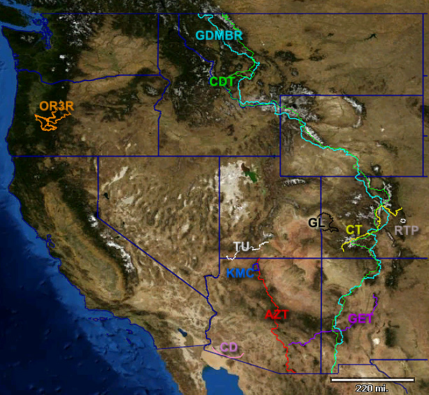
Singlespeed Arizona Course Maps

Saturday, January 17th, 2009


2009’s Singlespeed Arizona course maps are now available in the usual place:

http://topofusion.com/race.php

(including GPS data ready to upload, printable maps and all that good stuff)

48 miles of one gear suffering, with the addition of the High Chiva loop this year…

TopoFusion GPS Playback + Helmet Cam

Tuesday, January 6th, 2009

Check out this combo of TopoFusion’s playback feature with some helmet cam footage, courtesy of Mike Curiak of Big Wheels.

Though only a GPS single track is being played back, the video was done with TopoFusion’s Multi track playback function, so that the “on screen” stats of speed and grade can be displayed as the simulation proceeds.

Keep in mind that the GPS unit is on the rider in front of the camera, not the one with the helmet cam, so the GPS track tends to go around the corners a bit before the camera gets there.

New Color Aerials in TopoFusion Pro. v3.60 out!

Wednesday, November 19th, 2008


TopoFusion displaying new Color Aerials in Colorado

We’re excited about the release of version 3.60 of TopoFusion Pro. It features the new “Color” tileset that combines high resolution color aerial data from a number of servers into one “mega” tileset, covering most of the United States:


click to enlarge

For list of states covered go to:

http://www.topofusion.com/color-coverage.php

Download

Click [ HERE ] to download TopoFusion Pro with the new Color Tileset.

Registered users refer to your registration email for the download link, or go here to request your code and the download URL.

One note: the server responsiveness and quality vary from state to state. For some reason Texas and Pennsylvania are not in true color — they are red (?). But otherwise this is some very high quality and a MAJOR improvement for TopoFusion, especially over the black and white DOQQ data from Terraserver which is often old and sometimes fuzzy / washed out.

Also new, WMS servers

Version 3.60 also introduces custom WMS server support. Any WMS server can be served and cached by TopoFusion, as long as it can output in the EPSG:4326 projection (most can). For more info see WMS servers in TopoFusion.

For a complete list of changes see the Revision History

TopoFusion 3D map in BIKE magazine

Saturday, November 8th, 2008

November’s issue of BIKE magazine features a story on a 160 mile singletrack epic in Utah’s Wasatch range. The author of the article contacted TopoFusion for a 3D plot of their route, published on page 75, and also online:

http://bikemag.com/gallery/across_the_wasatch_markewitz_utah_mountain_biking_photos/

They had tried to get an acceptable result from Google Earth, but the “patch work” effect (from stitching together data from various sources) made the result inacceptable. TopoFusion’s Landsat tileset was just the trick for mapping this 160 mile GPS track. It’s consistent and great for large scale maps. For publication their art department fiddled with the colors to make it a little less “mars” like (see the magazine). Original from TopoFusion looks like this:


(Warning – large file – 2.5 mb jpg)

In the soon-to-be-released next revision of TopoFusion we can do even better. We’ve got statewide color aerials at very high resolution (~1m or better) coming ‘atcha (for most of the United States). Here’s what the Wasatch Epic track looks like on the new color aerials:

Still very consistent. Also note that to get a high resolution 3D export in Google Earth you need the $400 Pro version. And even then it’s only 4800×4800. TopoFusion can export to 8192×8192 as long as you’ve got a video card that can support it.

Pro v3.51 out – Oregon/Colorado/705 direct support

Friday, October 3rd, 2008


We’re pleased to announce the release of version 3.51 of TopoFusion Pro.

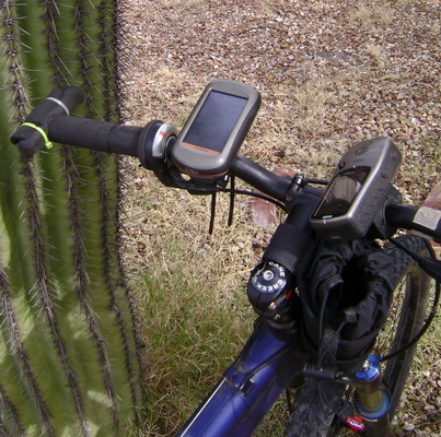
The latest revision adds direct support for the newest Garmin GPS units, like the Edge 705, Colorado, Oregon (shown above, mounted to handlebars) and Nuvi. These are the new “mass storage” device GPS units. TopoFusion has always supported them in that it loads and saves GPX and TCX files. But now you don’t need to do your own file management and be unsure if you got things into the correct directories — let TopoFusion handle it for you.

The new units are supported just like older USB and serial units are — direct transfer of tracks and waypoints. We’ve also added a few little tricks like auto-naming of tracks based on the filename. This prevents every track from being named “Tracklog” (the default if the track has no name field).

Also in this release is more Windows Vista friendly install and directory structure. Existing users won’t notice any change — settings and default directories will remain the same. New installs will now use “My Documents\My TopoFusion Files” by default, rather than storing everything in “Program Files.” This avoids the compatibility mode issues and the storing of files in the “Virtual Store.”

Download Link: Download TopoFusion

Full list of changes since v3.41:

3.51 – [10/03/08] (Full Release)

Separated transfer of waypoints and tracks for Garmin mass storage devices
(e.g. Edge 705, Colorado, NUVI, Oregon).
GPS transfer dialog now behaves the same for Garmin USB and Mass storage
Added track names (based on filename, and only if empty) to tracks upon upload
to mass storage devices. Now on Colorado/Oregon units uploaded tracks
will have names, rather than “Track log.”
Fixed crash unloading a newly downloaded file after using “Save all” command.

3.50 – [09/24/08] (Beta only)

Added direct upload support for Garmin mass storage devices
(e.g. Edge 705, Colorado, NUVI, Oregon series)
Updated Installer and default directories to be more Windows Vista friendly
Fixed double .INI file problems on Vista
For new installs only:
* Default tracks directory now “My documents\My TopoFusion Files”
* TopoFusion.ini and TopoFusion.log stored in “AppData\Local\TopoFusion”
Existing installs:
* Default tracks dir remains the same
* Current TopoFusion.ini file will be loaded, whether in
C:\Program Files\TopoFusion or in the “Virtual Store.”
* TopoFusion.log stored in “Appdata\Local\TopoFusion”
TopoFusion will now run without admin privileges on XP/Vista
(still need admin to install)
Installer now asks to run *after* closing
Fixed problems loading some NMEA .log files

3.42 – [09/10/08] (Beta only)

Added direct download support for Garmin mass storage devices
(e.g. Edge 705, Colorado, NUVI, Oregon series)
Changed default filename for downloaded tracks to YYYY-MM-DD
Downloaded “saved tracks” now default to their name if saved

TopoFusion Basic v2.975 released

Wednesday, October 1st, 2008

Today we released a new revision of TopoFusion Basic — version 2.975. This version includes several bug fixes and some additional functionality.

Smart merging is a great new feature that really simplifies track merging. Trailing extra points on drawn tracks was another really nagging UI issue that has been resolved.

We tried a couple approaches to get Landsat tiles to download again in the Basic version, but it just isn’t possible. The way Basic talks to the Nasa server simply isn’t supported anymore. If you want new Landsat tiles, you will have to upgrade to the Pro version of TopoFusion, which besides working, downloads much faster than Basic ever did, and stitches them together much more seamlessly.

If you’re using Basic and have existing Landsat maps already downloaded they will continue to work. But we have disabled the code that tries to download tiles and replaced it with a (one time) error message.

Download Link: Download TopoFusion

Other changes, from the revision history:

2.975 – [10/01/08]

Fixed crash in “edit track properties” when editing info
Fixed intermittent “unknown exception” on finishing track download
Fixed bug causing main TF window to become tiny when un-maximizing
Added “smart” merging (track merge tool)
– also: holding shift is no longer required to merge
Fixed problem with stray point added to end of drawn track
Fixed crashes loading some network files (removed maketopology()).
Updated copyrights on splash and about
Disabled Landsat tiles by default, added error message indicating new landsat downloads non-functional (Existing downloaded landsat tiles will still load and display)

——-

Thanks!

bikepacking.net launched – new site using TopoFusion

Sunday, September 28th, 2008

bikepacking.net is a new site focused on multi-day travel on the bike. The focus is on off-road (mountain bike) touring, but the concepts apply too all forms of overnight travel.

bikepacking.net will make extensive use of TopoFusion software, as already seen in the Route Matrix. Stats, profiles, and map images are available for many of the bikepacking routes. Also look for GPX downloads, merged and edited using TopoFusion.

Other features on the site include a web forum and gear reviews.

We’re excited about this new site, and the concept of bikepacking in general. Planning bikepacking trips was one of the main reasons we wrote TopoFusion in the first place!


Final White Mountains GPX and maps posted

Monday, September 15th, 2008

We just posted the final revision of the Tour of the White Mountains course data. Find it over at the TopoFusion events page:

TopoFusion events

We’ve been mapping and helping with development and course planning for Epic Rides events for six years now. The White Mountains are sure to be another successful Epic event!

Official race site: http://www.epicrides.com/towm/towm.htm

Version 3.41 released – Australian Topos and line styles!

Wednesday, August 20th, 2008

We’re pleased to announce the release of a new version of TopoFusion.

The biggest addition to this version is access to topographic maps for all of Australia, courtesy of the excellent MapConnect server:


For more details on these maps see available imagery. We’re excited about this addition since it has been a long requested feature, and we have a few potential projects in OZ as well. Find the Australian maps paired with the Canadian Topo tileset — there’s no overlap so they share the same tileset.

The other major addition is “GPX styles.” This allows users to set and display attributes such as width, color, opacity and patterns to GPS tracks and drawn lines. This is a great improvement for map making, and is especially useful for Trail Networks.


To change these settings, right click on a track in the map window and choose “Track Properties”. The dialog looks like this:


These attributes are saved in the “GPX styles” schema, an extension to the GPX format that is supported by several other mapping programs.

Full list of changes since v3.39:

3.41 – [08/15/08]

Cut tracks now inherit the original track’s color/width/pattern/etc
Fixed File Properties to only apply color to all tracks when color is
actually changed
Fixed bug when merging tracks while download box or drawn track is active

3.40 – [08/12/08]

Added Australian Topo Map server!
Covers all of Australia
Shares tileset with Canadian topo – “Can Topo” now “Can/Aus” tileset.
Can/Aus downloads Canada Topo in northern Hemisphere, Aus Topo in southern
Added support for GPX_style extension (also KML Styles)
Added per track line width
Added per track coloring
Added per track opacity
Added per track pattern (dash/dot, et cetera)
Added track names to KML exports
GPX files now saved as GPX 1.1
Drag and Drop of files now supported for main map window
(previously only active file list could be dropped into)
Fixed synchronization issues between profile/simplify/waypoint/track dialogs
Fixed infinite loop with large GIS waypoint files, skipping at high zoom levels
Fixed false clipping for long track segments
Fixed problem reloading tiles when clicked outside current UTM zone

Dances with Dirt Ultra – special race version of TF

Monday, August 18th, 2008


Dances with Dirt is a 50k / 50 mile ultra running event based
out of “Hell, Michigan.” It’s September 6th, 2008. Here’s a description of the course:

The footing (What footing?) is rocky, muddy (a few river crossings) and
loose in places. The trail is not maintained (non-existent) in some areas. We
love this stuff and hope you do too. ILK RULES! Bring on the ILK! ILK me! Is
the trail as tough as advertised? Yes and No. I’t s no run down a nature trail
(but at times it is just that), you will get wet and muddy. You won’t get swept
down stream in any whitewater. Some big hills but no supplemental oxygen is
needed. Our descriptions are a disclaimer. All in all, a great run in a
beautiful environment…with stupid spots.

Sounds like a great time! Race organizers used TopoFusion to map and
tweak the course. And in a special promotion, we’ve offered a “Dances with
Dirt” version of TopoFusion. This free version of TopoFusion doesn’t have any
Demo tiles obscuring maps, nor is it limited to three files open. It is,
however, limited to viewing the area (southern MI and northern IN/OH). This
version also includes all the GPS files for the Dances with Dirt course.

To download the Dances with Dirt version of TopoFusion, and for some instructions head
over to:

Dances with Dirt TopoFusion demo page.