Show Posts

This section allows you to view all posts made by this member. Note that you can only see posts made in areas you currently have access to.


Messages - ScottMorris

Pages: 1 ... 8 9 [10] 11 12 ... 32
451
TopoFusion Anouncements / Re: v4.31 - myTopo and TopoFusion
« on: October 19, 2011, 11:37:10 AM »
Ah, what you are seeing is that in 3D mode TF is changing to a different resolution level (it is getting more detailed).  If you zoom in while in 2D mode and in myTopo, you'll see those exact corrupt map tiles come up.  Once you find them on that zoom level, use the reload maps tool to point click them and you should be good to go.

Let me know if that doesn't solve it.  Thanks.

452
TopoFusion Anouncements / Re: v4.31 - myTopo and TopoFusion
« on: October 18, 2011, 02:34:40 PM »
3D is working for me in myTopo.  You may just have a general 3d problem.  What are you seeing, and does it work in other tilesets?

Thanks.

453
TopoFusion Anouncements / v4.31 - myTopo and TopoFusion
« on: October 17, 2011, 01:37:32 PM »

myTopo maps in TopoFusion

TopoFusion Pro version 4.31 is out, a quick response to a change in one of the software's key tilesets -- the myTopo layer, courtesy of 
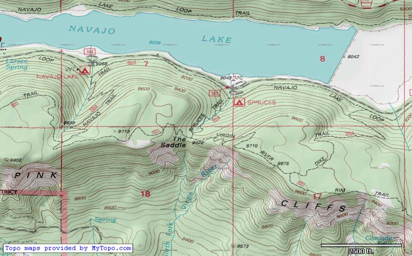
myTopo.com.  Originally introduced in v4.0, July 2010, myTopo maps are a major improvement over MSRMaps/Terraserver topo maps, featuring better clarity, more current maps and forest service updates (like forest road and trail numbers).

Last week (10/12/11) a server change caused new maps downloaded by TopoFusion to come in jumbled and corrupted.  If you are getting myTopo maps that look like this:


this update is for you.  Once you update you can use the reload maps tool (looks like this on the toolbar: ) to point-click and force a re-download of any maps that came in corrupted.

If you haven't checked out myTopo's other services, you should.  Besides the awesome (and free!) set of Topo map tiles for the entire US (and Canada) they offer some really nice printed map services.  If you're in the market for a printed map, buying one from MyTopo is a great way to say thanks for the free maps in TopoFusion.  Check them out by clicking on their logo.


For full details on what else has changed, check the revision history linked below.


Head over to the Download Page to try TopoFusion out, free of charge.

Registered users refer to your registration email for the download link, or go here to request your code and the download URL.

Full list of changes

For a complete list of changes see the Revision History

454
TopoFusion Anouncements / Re: MyTopo tile corruption
« on: October 17, 2011, 01:27:48 PM »
v4.31 was released with the fix.

455
TopoFusion Pro / Re: Open Aerial
« on: October 14, 2011, 11:41:06 AM »
Roger -- 4.31 is out.  See info here:

http://www.topofusion.com/forum/index.php?topic=6621.0

Should be better, but not perfect.  Hopefully it'll settle down (with better imagery too!) soon.  Let me know how it goes.

Thanks.

456
Beta Testing / Re: Beta 4.3 - MyTopo Fix, KMZ
« on: October 14, 2011, 11:39:54 AM »
The Open Aerial server still seems to be giving some bad responses at times, returning blank (white) tiles.  v4.31 improves on the performance significantly, but in some areas errors are still happening.

It appears they may be upgrading imagery (better resolution) in some areas.

(new on left, old on right)

457
Beta Testing / Re: Beta 4.3 - MyTopo Fix, KMZ
« on: October 14, 2011, 11:32:50 AM »

Another server fix in v4.31:

4.31 [10/14/11]  (Beta)

Fixed missing tiles in Open Aerial tileset (ignoring bad server responses)

458
TopoFusion Pro / Re: Open Aerial
« on: October 13, 2011, 09:58:55 PM »
Another user reported this a while back, and it resolved itself, but is now back again (I am seeing it too).

The error is:

[Errno 5] Input/output error: '/data/tiles/naip/15/006/288/013/248.png.lock'

I just added a fix to ignore that message and will do a new beta in the morning.

Thanks.

459
TopoFusion Anouncements / Re: MyTopo tile corruption
« on: October 13, 2011, 03:41:10 PM »
If you haven't already, you should check out myTopo.com -- besides providing TopoFusion with an awesome (and free!) set of Topo map tiles for the entire US (and Canada) they offer some really nice printed map services.  Check them out at:

http://mytopo.com

460
TopoFusion Anouncements / Re: MyTopo tile corruption
« on: October 13, 2011, 03:39:49 PM »
Fix is out in v4.3, now in beta.  Should be a quick turnaround before it's available in the free and full versions.

Here is what the corrupt myTopo maps look like.  We just weren't handling "chunked" http responses correctly, and their server changed to sometimes returning "chunked" data.


461
Beta Testing / Beta 4.3 - MyTopo Fix, KMZ
« on: October 13, 2011, 03:38:10 PM »
If you are getting MyTopo maps that look like this, you should download the new version, out in beta form now.


http://topofusion.com/beta.php

(for registered users)

Other additions/fixes/etc:

4.3 [10/13/11] (Beta)

Fixed corrupt myTopo maps due to server change (chunked responses)
Added ability to read .KMZ files (zipped .kml)
Added new unit type "Nautical" for nautical miles and knots
Added ability to expire all maps for OSM, Open Cycle, Mapquest, Open Aerial and
  myTopo maps (Options->Preferences->Tilesets)
Improved accuracy/detail when adding elevation data to tracks
Changed encoding of all xml files (GPX, KML, etc) to ISO-8859-1 from UTF-8 to
allow special characters
Fixed error 380 with Garmin Astro Live Tracking
Fixed "place waypoint" button on Goto form to copy both coordinates

462
TopoFusion Anouncements / MyTopo tile corruption
« on: October 12, 2011, 08:18:11 PM »
As of sometime this week, myTopo tiles are coming into TopoFusion corrupted, resulting in jumbled or odd colorizations on some tiles (not all, but enough that it's significant).

This is due to a change in the way the tiles are served.  I've got a fix and will get a beta/full release out very soon, hopefully tomorrow 10/13/11.

Thanks for the patience.

463
TopoFusion Pro / Re: Elevation comparisons between Edge and eTrex
« on: October 05, 2011, 09:05:05 PM »
Hi,

The 'correct' elevation gain figure is a difficult concept, as you are no doubt noticing.  For what it's worth, the original Edge units (205/305) are notorious for exaggerated elevation gain, simply because their elevation readings have a lot of noise that get added up in the *sum* that elevation gain is.  I wouldn't trust a 305's numbers without some filtering.

The best I hope for is consistency between tracks from the same unit, or by using the correct elevation using DEM button as you found.  But in general Garmin's own units I tend to feel are too low, and TopoFusion's base numbers are a bit too high, unless you correct with DEM, or pull up climbing analysis and look at some of the filtered (e.g. training center preset) values.

Barometric pressure can make a change like that, but the 305 doesn't have a barometer (right?) so it wouldn't be that in this case.  The 30 does, but generally a normal ride isn't long enough to notice that effect, IMO.

Hope that helps a bit.  It's a bit of a sticky issue.

464
TopoFusion Pro / Re: Can all "Open" caches expire on demand?
« on: September 30, 2011, 11:54:55 AM »
Done.  There's a dropdown in the next version allowing expiring all OSM, Open cycle, mytopo, mapquest and open aerial.

Thanks for the suggestion.

465
Feature Requests / Re: addition of Unit types
« on: September 29, 2011, 09:35:49 PM »
You got it.  I added it today and it'll be in the next version.

466
TopoFusion Basic / Re: automatic backup?
« on: September 29, 2011, 03:18:16 PM »
Re: logbook.  There's no batch tool for logbook, but there should be one.  I would have found it handy in the past.  Sounds like some of your files have moved, which is a problem with the log format.  If you know the change you might be able to open the TFlog.csv file and do a 'search/replace' to update the paths accordingly.

467
TopoFusion Basic / Re: automatic backup?
« on: September 29, 2011, 03:17:04 PM »
The reasoning is that at least you have the original file in case you mess something up editing.  It is true that some people don't edit files regularly, though.

And the newer units do a pretty good job of storing archived data.  Though I still like having a copy on my hard drive just in case.

You might be able to prevent TF from creating files in the backup dir by setting it to 'read only'.  Or just delete it every once in a while.  I guess an option might be nice to have, but I don't see very many people turning it off.

468
TopoFusion Pro / Re: log book erased
« on: September 29, 2011, 03:01:03 PM »
Hmm.  Are you just right clicking on the file and doing 'Analysis->Add to Logbook' ?

Yep, bike tracking would be cool...

469
TopoFusion Pro / Re: Fabricated Timestamps
« on: September 29, 2011, 02:40:06 PM »
Hi Don,

How are you uploading a track, are you first saving it out as a .CRS file?  Remind me what GPS you have.

You might be able to adjust the speed a bit by decreasing the number of points in your track.  If you take it down to 25% of the total number of points you might get some more reasonable speeds.

I don't think a precise way of fabricating times is worth effort, but maybe an option to go with a preset speed would make sense.

Thanks

470
TopoFusion Basic / Re: automatic backup?
« on: September 29, 2011, 01:40:28 PM »
Hi joe,

The backup feature has been there for quite a while.  I never thought that anyone would want to turn it off since GPX files are so small that even a GPS freak like myself doesn't eat up too much disk space.

Is it the disk space that bothers you about it?

471
TopoFusion Pro / Re: log book erased
« on: September 26, 2011, 09:18:49 PM »
Hey Aaron,

The logbook should be resilient to crashes.  Hmm. 

Did you by chance change your default tracks directory?  That's where the logbook is stored, and would result in a clear/new log.  It's easy to copy the TFlog.csv file back into your new default tracks dir if so.

If not, look around for a TFlog.csv file -- it's got your data in it.

Let me know if that's it or not.

472
TopoFusion Basic / Re: Choosing maps in drop down
« on: September 24, 2011, 09:37:43 AM »
Yeah, that doesn't sound like the intended behavior.  It's probably the fact that the dropdown is scrolling on a screen that is too small.  I'll try it on my netbook.

Try the "map" menu as a workaround.  It should  have shortcuts to all the major map types, and less choices since the different zoom levels aren't spelled out.  Learn the keyboard shortcuts, too, they are quite handy for flipping between map types.

I'll see if I can figure anything out on the scrolling drop down.  Thanks for the post.

473
TopoFusion Pro / Re: HELP! - Couldn't open maps.dat for writing
« on: September 24, 2011, 09:35:30 AM »
22 hours, wow!  It's not the most efficient code, for sure.

Does it give the same error, or something different, or just no maps, or?

474
TopoFusion Pro / Re: HELP! - Couldn't open maps.dat for writing
« on: September 22, 2011, 04:40:40 PM »
Alright, it took a bit, but it worked on one of my Maps0.dat files -- resurrected a correct mapindex.dat file for it!

Put fixmaps.exe into your map directory -- you may want to rename or copy the current mapindex.dat file since it will get overwritten.  Run it (for you it may take an hour or more, and the progress bar is messed up, it goes beyond 100%!).

No guarantees!  For use with v4.0 TF and up only (in case other people end up on this thread).

We'll see if it lets me attach a .exe file to a forum post or not.

475
TopoFusion Pro / Re: HELP! - Couldn't open maps.dat for writing
« on: September 22, 2011, 03:54:30 PM »
Found it, and it needs updating as I suspected.  I'll throw a little time at it right now and see if it'll roll.

476
TopoFusion Pro / Re: Access violation with Paint
« on: September 20, 2011, 12:18:08 PM »
Hmm.  Hard to think of what a windows update would  have to do with it, unless it mucked with your video card's drivers or something.

First thing to try is to reset to TF defaults:

To reset back to default settings, delete (or rename) the file TopoFusion.ini.  It should be here:

C:\Documents and Settings\*Your USER NAME*\Local Settings\Application Data\TopoFusion\TopoFusion.ini

See if it runs after that.

477
TopoFusion Pro / Re: HELP! - Couldn't open maps.dat for writing
« on: September 15, 2011, 07:11:46 PM »
Unfortunately I am heading back to AZ this weekend, so it'll be a few days before I can take a look.  Please bug me about it mid-next week if I haven't gotten back to you.

Cheers.

478
TopoFusion Pro / Re: HELP! - Couldn't open maps.dat for writing
« on: September 14, 2011, 07:52:16 PM »
Thanks, got 'em.

It does seem like your mapindex.dat file got truncated -- it's only 92mb and it should (by my rough calculations) be closer to 125 mb.

Is there a maps297.dat file?  #296 looks like it is full.

I will have to dig up the mapindex rebuilder tool, and we can try that.  It may need some updates for the newer file structure in v4 of TF Pro.

Thx

479
TopoFusion Pro / Re: Google My Tracks
« on: September 08, 2011, 09:06:04 PM »
Thanks tooslow!  Looks like it's just really noisy elevation data, such that it's picking up bonus climbing.  They must be doing some extra filtering (since they know the data is quite errant) on the phone.

480
TopoFusion Pro / Re: Shaded Relief
« on: September 05, 2011, 04:42:20 PM »
You're right, it should be a toggle.  Try the actual toggle on the tool bar, or the check menu option on the 'Map' menu.

I added that button just as a shortcut to turn it on, but it makes perfect sense to turn it off there too!  Will do.

481
TopoFusion Pro / Re: TopoFusion 4.22 - Goto Location/Add Waypoint issue
« on: September 02, 2011, 10:07:21 PM »
Thanks, you are right, this is a bug!  We'll get it fixed in the next version.

482
TopoFusion Pro / Re: Help...Trying to download Pro onto new Mac
« on: August 31, 2011, 02:26:45 PM »
TF won't run natively on Mac OSX, sorry!  Your options are all pretty complicated ones, but if you use VMWare Fusion (PC/windows emulator) plus Windows, several users have reported that the program runs well.

483
TopoFusion Pro / Re: A few questions :)
« on: August 31, 2011, 02:25:09 PM »
Paul,

Cool, glad that the tiled feature will work.  That's an interesting way to add more detail to a custom garmin map.

The myTopo export will be in the highest detail setting -- which actually can be changed via a toggle in Options->Preferences->Tilesets.  There's a checkbox there that enables a higher resolution myTopo box -- but beware, it means more tiles for the same area.  I like the higher res maps for use in TF itself, but for exports and custom maps I generally don't find it necessary.

484
TopoFusion Pro / Re: GPX editor
« on: August 29, 2011, 12:35:25 AM »
You can use the merge tool to choose a single track and then right click and save it out into a new file.  Sounds like you might have to do that 20 times though... :)

Or you can click on all 20, save, then go back in and cut up the connecting line segments.  Not as clean though...

485
TopoFusion Pro / Re: Open Aerial Tiles
« on: August 29, 2011, 12:32:28 AM »
Hey Ken,

Are you still seeing this?  I think I checked when you made the post and got some bad tiles too, but it seems fine as of today.

Thanks.

486
TopoFusion Pro / Re: A few questions :)
« on: August 29, 2011, 12:29:45 AM »
Hi there,

Let me see if I can help.  I'm a little curious why you are using .kmz files to load up into Photoshop -- seems like exporting direct to .jpg might make more sense?  Or you are trying to preserve the calibration info in the .kmz I guess?

Does your TF crash when exporting a .jpg that is larger than 4000x3000?  How recent is your video hardware?  If you look in the TF diagnostic log it'll tell you the max texture size for your card  But sometimes it will fail below that number too.  You might try looking for newer video drivers.

The projection issue has to do with the requirements for Garmin's Custom Map feature, so there isn't too much we can do about it.  What tileset are you exporting, by the way?

487
TopoFusion Pro / Re: HELP! - Couldn't open maps.dat for writing
« on: August 24, 2011, 09:12:16 AM »
Hmm.  Can you send a screen grab of what your map folder looks like?  I just want to make sure all the files are there and that the sizes make sense.

One thing to try it copying (!) everything to a new directory.  It's possible there's something wrong on your hard drive.  If it succeeds it may be that TF can open the copy.

At one point we did have a util that rebuilds the mapindex file, but it hasn't been used/updated for a while.  I can take a look later.

488
TopoFusion Pro / Re: HELP! - Couldn't open maps.dat for writing
« on: August 23, 2011, 08:43:30 AM »
That kind of makes sense, that a file lock would still be on it.

But rebooting did not help?  That should have cleared it.

489
TopoFusion Pro / Re: HELP! - Couldn't open maps.dat for writing
« on: August 23, 2011, 08:14:57 AM »
Best thing to do first is reboot your computer.  It could just be a stray file handle that has grabbed the index or one of the mapsX.dat files.

If that doesn't work, does it go into read only mode and talk about CD-roms, or just say not open for writing, and then fail?

490
TopoFusion Pro / Re: Empty effor and difficulty indexes?
« on: August 22, 2011, 05:21:45 PM »
Sure, if you could send it over (smorris@topofusion.com) that would be great.  Hopefully I can figure out what caused it.

491
I'm seeing the same thing... the server is very slow to respond, if it responds at all.  Unfortunately there are no guarantees on this alternate ownership server.  We can only hope it comes back to full operation and stays up...

Thanks for the post, I hadn't used the layer for a few days.

492
GPS, Trails, Training / Re: GPS Suggestions?
« on: August 18, 2011, 10:12:14 AM »
The touchscreen is just a little awkward to use while on the handlebars and riding.  Oregon is a little better but the combo of the touchscreen and sub-par visibility is a little annoying even there.

In the hand both units are great.  I don't have a screen protector on but have found polarized lenses to be helpful.

I though the new eTrex had a street date of right around now, but I know they often get pushed back too...

493
TopoFusion Pro / Re: Empty effor and difficulty indexes?
« on: August 16, 2011, 09:32:49 AM »
Sorry, this one has stumped me.  It's not the best solution, but I'm guessing if you reset your TF settings by deleting your .ini file, you'll get the numbers back.

To reset back to default settings, delete (or rename) the file TopoFusion.ini.  It should be here:

C:\Documents and Settings\*Your USER NAME*\Local Settings\Application Data\TopoFusion\TopoFusion.ini

494
GPS, Trails, Training / Re: GPS Suggestions?
« on: August 16, 2011, 09:31:31 AM »
I like my Dakota 20, except for the touch screen.  I'm hoping the new line of eTrex will be the go-to GPS for MTB and general use, but I haven't seen one yet.  The Montana is gigantic -- too big for handlebars is what I have heard.

I'd wait a bit for more reports/testing on the new eTrex.

495
TopoFusion Pro / Re: downgrade from pro to basic
« on: August 06, 2011, 05:13:13 PM »
Glad you got it working, and thanks for posting your solution.

496
TopoFusion Pro / Re: downgrade from pro to basic
« on: August 04, 2011, 05:26:35 PM »
I just installed TopoFusion on my mac using parallels and XP. The first time I launched the app I got the message below:

Right after launching this pop up appeard:
Warning: Default tracks directory was invalid or does not exist. Could not create one either (trying to create \\psf\Home\Documents\My TopoFusion Files) Check permissions or change to admin.

Then this pop up appeared:
Module: frmMain
Prodedure: Load
Line Number: 0
Error Number: 380
Description: Invalid property value

The log shows this:
TopoFusion 4.200 Log Begin
SizeChanged : Not initialized, aborting


All of the attributes in the folder path above are read only and it won't let me change them. I am the computer administrator.

---

The solution:

I figured this out. I'm sending you how I resolved this in case this issue comes up again.

Notice that in the first pop up I told you about, the path is in unix format (\\psf\Home\Documents\My TopoFusion Files). Using windows explorer I mapped a drive (T:\) to the folder.

Now it works - no pop ups!


497
TopoFusion Pro / Re: downgrade from pro to basic
« on: August 04, 2011, 05:25:31 PM »
Hi,

Thanks for the feedback with Parallels.  I have recently heard from another user about problems with paths he had.  I'll post it here in case it helps.

But to answer your question, a Pro code works (with no modification) on Basic -- but you have to download the full version of Basic from the same page you downloaded the full version of Pro on.

We are not planning any specific changes for Parallels compatibility, maybe the below will help.

498
TopoFusion Anouncements / v4.22 Released - Land Ownership fixed
« on: August 03, 2011, 01:51:12 PM »

Land Ownership map set legend

TopoFusion Pro version 4.22 is out, with some nice fixes and enhancements to the software.  One key change was the reinstatement of the Land Ownership Layer, which had a very serious server change, rendering previous versions of the software unable to download/display new Land Ownership maps.  The land ownership layer has been incredibly useful for our Search and Rescue as well as Trail Planning users, so we are very happy to have it back.  Full details on the Land Ownership change: http://www.topofusion.com/forum/index.php?topic=6270.0

For full details on what else has changed, check the revision history linked below.


Head over to the Download Page to try TopoFusion out, free of charge.

Registered users refer to your registration email for the download link, or go here to request your code and the download URL.

Full list of changes

For a complete list of changes see the Revision History

499
TopoFusion Pro / Re: Merging Map Data
« on: July 30, 2011, 10:43:27 AM »
Hey Bill,

Right, not currently a feature, but it is possible to do.  Would probably be best in a standalone maps crunching program, rather than in TF itself...

500
TopoFusion Pro / Re: Empty effor and difficulty indexes?
« on: July 20, 2011, 11:04:58 PM »
I think the problem is the "moving threshold" (options->properties->units->minimum speed to consider moving).  If it is too low, (can be esp. true on a hike) you won't "score" and difficulty points since the software is considering you to not be moving.

Try increasing it a bit.

Pages: 1 ... 8 9 [10] 11 12 ... 32