Show Posts

This section allows you to view all posts made by this member. Note that you can only see posts made in areas you currently have access to.


Messages - ScottMorris

Pages: 1 ... 29 30 [31] 32
1501
Feature Requests / Export To HTML
« on: July 22, 2008, 12:59:36 PM »
We'd love to add Google maps, and it might be possible in a somewhat more limited form (with limited functionality).  But having it fully integrated isn't much of an option.

Thanks for the suggestion.  We need to think about it some more.

1502
Feature Requests / Export To HTML
« on: July 22, 2008, 09:51:35 AM »
Right, the CSV export isn't really for stats -- just getting the points out.

There's an automatically generated file (assuming you downloaded your tracks in TopoFusion) called TFlog.csv that does have a number of stats in it.  It's in your default tracks directory.

(You can also add a file to the log if you didn't download in TF).

For the future, I really like your idea of an "export stats" function.  I'm sure it'll be useful.  Perhaps a "copy stats to clipboard" function would be handy as well.

Thanks for the suggestion.  Give the logbook file a try in the meantime.

1503
Feature Requests / GPS Live Tracking Bug
« on: July 21, 2008, 02:02:24 PM »
Hmm, sounds like a bit of a can of worms.

Not sure exactly what we can do on TF's end about it.  Sounds like what they do is manually shut off the USB device before hibernation.

I will try it on my end, while in debug mode, and see if there's something simple I can do like a more "hard reset" type of thing.

Too bad Windows doesn't handle it better...

1504
Feature Requests / Export To HTML
« on: July 21, 2008, 01:48:16 PM »
Yes, try using the PhotoFusion "generate HTML Imagemap" function.

You don't need to have placed any photos with the GPS track, just have it generate the HTML page -- at the bottom there will be a table with various stats in it.

Otherwise, another idea is to look at your TFlog.csv file -- you can copy lines out of there to make a HTML table out of.  Those stats will be in a little different units though (often Metric), but conversions shouldn't be too hard.

Hope that helps.

1505
TopoFusion Pro / no time data...magellan explorist
« on: July 21, 2008, 01:39:42 PM »
Sorry about the delay - we have been out traveling by bike and away from computers.

There should be time info there for sure.  Also elevation.

Can you email the track file you are loading to support@topofusion.com and we will take a look?

Thanks and sorry about the issue.

1506
TopoFusion Pro / saving parts of a track as separate files
« on: July 21, 2008, 01:37:47 PM »
Sorry about the delay - we have been out traveling by bike and away from computers.

The method you describe is one way to do it.

Another is to use the scissors tool to cut between the "hard" and "easy" parts.  Then use the "merge tracks" tool to click on either the hard or easy section, then right click and choose "save as...".

If the tracks intersect you might try the network tool as well -- that will pre-split the tracks, possibly at the right points you were looking for.

Hope that helps.

1507
Beta Testing / v3.37 - arrows, more updates
« on: July 02, 2008, 10:54:30 AM »
Thanks, I added TN, but I don't know about "statute" -- I think most people will assume we're not using survey miles, no?

1508
Feature Requests / GPS Live Tracking Bug
« on: July 02, 2008, 10:53:41 AM »
I tried this today (shutting off the GPS while tracking) and it seemed OK.

When you try to hit "start tracking" again, do you get an error message eventually?

Mine very quickly realizes the GPS is no longer there and switches the "stop tracking" button to "start tracking."  Then restarting seems OK, even if the GPS doesn't have a lock yet.

Thanks.

1509
TopoFusion Pro / 3D download problems
« on: July 01, 2008, 06:30:21 PM »
Back up.

1510
TopoFusion Pro / Elevation Server Error
« on: July 01, 2008, 06:30:06 PM »
Back up.

1511
TopoFusion Anouncements / 3D downloads back
« on: July 01, 2008, 06:29:26 PM »
The server is now serving elevation data once again.

3D downloads and "add elevation to track" are back.

Thanks for the patience.  We are working towards an elevation caching system so this isn't as much of an issue in the future.

1512
TopoFusion on other OS - Mac / Linux / Topofusion on the Mac
« on: June 30, 2008, 02:16:26 PM »
Sounds like a Virtual PC issue.  I think that VMFusion works with TF and USB, but I'm not sure if anyone has been able to get Virtual PC to work.

I'd try the native Mac version of mapsource from Garmin, then save out to .GPX and open in TF.

1513
TopoFusion on other OS - Mac / Linux / Topofusion on the Mac
« on: June 30, 2008, 12:56:44 PM »
I think that should have installed them, yep.

Is Trip and Waypoint able to communicate with the GPS?

The USB emulation is a tricky thing.

1514
TopoFusion on other OS - Mac / Linux / Topofusion on the Mac
« on: June 30, 2008, 11:56:29 AM »
Have you installed the Garmin USB drivers (available from Garmin.com) ?

1515
Feature Requests / Tracks - Incremental and autosave
« on: June 29, 2008, 09:36:30 PM »
Excellent, thanks for the feedback on it!

1516
TopoFusion Pro / Elevation Server Error
« on: June 29, 2008, 03:44:00 PM »
Hmm, it's supposed to switch back, but it probably errors out first.

Wait until the server is back, then it will just change briefly, and change back.

It's not a bad idea to change back even with an error, though.  Thanks.

1517
TopoFusion Anouncements / 3D downloads back
« on: June 29, 2008, 03:26:09 PM »
It's looking like it may be until July 1st before the issue on the server is corrected.

Thank you for your patience.

1518
TopoFusion Pro / Elevation Server Error
« on: June 29, 2008, 03:25:18 PM »
Yup - Nasa server is not currently serving 3D data.

'<img'>

There's a topic in the announcements forum about it.

Should be back Jul 1.

1519
Archived Support / I broke the logbook
« on: June 22, 2008, 06:31:51 AM »
Hey Rich,

Likely the log file isn't quite in the right place.  In Vista it overrides certain paths and directs them elsewhere.  I can't recall exactly where c:\program files\topofusion goes, but I'd do a system wide search for GPX files you have downloaded, or I think even the .ini file goes there.

If you've downloaded anything there should be another TFlog.csv at that location too.

Hope that helps.  Also be careful re-saving in excel.  Sometimes it puts quotes around the strings and gives some trouble.  Not all versions seem to do that, though.

1520
TopoFusion Anouncements / 3D downloads back
« on: June 21, 2008, 08:49:04 PM »
The Nasa server is having a problem with the 3D / elevation downloads as of today.

The same server provides the landsat tiles and those are coming in just as fast as ever, so it appears to only be an issue with the 3D.

Sorry about the trouble.  We've emailed the server's admin and will update as soon as we know more.

Until then, you'll get a "not responding" error message when trying to switch to 3D.

Thanks for your patience.

1521
User Projects / Gamber Johnson Laptop Mount
« on: June 20, 2008, 08:39:07 AM »
Ah!  Answered my own question - you are obviously using a Garmin.

Looks like a great setup.  I'm so jealous that you have all that capability while out in the field.

1522
Feature Requests / GPS Live Tracking Bug
« on: June 20, 2008, 08:33:54 AM »
OK.  I will try this out.

Is it actually hibernate, or "sleep"?  Usually hibernate completely shuts off the computer, saving out all contents of memory to the disk (and it's user activated).

Also, I forget whether you are using a NMEA (likely) or Garmin GPS for tracking?

Thanks.

1524
Feature Requests / Tracks - Incremental and autosave
« on: June 17, 2008, 09:50:34 AM »
FYI - this went into the current beta.

Available in full release / demo soon.

1525
Beta Testing / v3.37 - arrows, more updates
« on: June 17, 2008, 09:49:46 AM »
The 60 mile Tour Map


Biggest improvements this go-round are the addition of automatic directional arrows (toggle on toolbar and settings in preferences) and addition of auto-saving for live tracking (as well as some general improvements to that feature).

Here's the complete list of changes:

Added direction arrows to tracks
  Toggle on toolbar turns them on/off for all tracks
Settings for arrow size, frequency, color are in preferences->colors
Added additional context menu to help choosing tracks/waypoints
(used when right clicking on multiple tracks / waypoints)
Added "Highlight file in Active List" to right click menu
Added more descriptive title to standard right click menu
Added ability to write Live Tracking tracklog out to disk periodically
Fixed problems between interplay of live tracking log and drawing/merging tracks
Fixed memory leak in live tracking log
Live tracking dialog can now be minimized, and gives a warning when closed
Changed draw tool's bearing to True North rather than Grid North
Fixed possible bugs in very large network computations
Lowered memory overhead of network code
Added "out of memory" error to very large network computations
Added "Green" and "Blue" track shading settings
Added "Check for Updates" button to About Menu
Drag and drop of .GPX file to TF window now only re-zooms if
a single file is dropped.  Multiple files just load.
Fixed "can't get date from win.ini" error message

1526
TopoFusion Pro / Problme with transfer from Garmin to TF Pro 3.32
« on: June 17, 2008, 08:09:16 AM »
Issue fixed in latest beta -- full release soon.

Thanks again for pointing it out.

1527
User Projects / Topofusion in video
« on: June 15, 2008, 04:23:30 PM »
Yep, it would be nice to sync up broken video segments as you describe.  I'm not sure there is a standard way to store time stamps for all the various video formats out there.

I'm no mpg or quicktime expert, though.  If there is such a format that is fairly widespread I could take a look at it.  It would be cool to pull images every, say 30 seconds, and display them on the map much like PhotoFusion.

Among other cool things you could do...

1528
TopoFusion Pro / Problme with transfer from Garmin to TF Pro 3.32
« on: June 15, 2008, 04:18:41 PM »
Hi,

Hmmm.  I have a hunch that something got messed up in your time/date settings in the TopoFusion.ini file.

Do you use any international settings, or switch between them (especially date formats?)

Try removing (or moving do a different directory) your TopoFusion.ini file.  If starting with fresh settings gets rid of the problem, could you email us the offending .ini file?

Otherwise, if you could get the exact error message, that would help.  It shouldn't be too hard to figure out what's going on.

Thanks and sorry about the problem!

1529
Feature Requests / Export Elevation Data
« on: June 14, 2008, 03:00:31 PM »
Just a note - we added this ability to the latest beta version (out as a public release soon).

If you go to the Lap Analysis feature you can set an interval.  Then exports to .CSV contains various statistics at that interval, and as of v3.36+, an interpolated elevation at that point is also there.

500 mile route?  What event?

1530
TopoFusion Anouncements / topofusion.com back up
« on: June 13, 2008, 08:29:38 AM »
Ugh, our server went down again, for a good part of yesterday.

Finally back up, and emails are trickling in.  However, I have reason to believe not all emails made it through, so if you sent something and don't already have a response, please email us again!

Sorry about the downtime.  That should be the end of it!

1531
Feature Requests / Tracklog Playback linked to Video playback
« on: June 13, 2008, 08:28:07 AM »
That's definitely TF in the video.

Here is another topic on the forum with people doing similar things:

http://www.topofusion.com/cgi-bin....#entry5

1532
TopoFusion Pro / Bearings using drawing tool
« on: June 10, 2008, 07:26:50 PM »
Larry,

Thanks for politely pointing out that TF is basically computing the wrong thing.

I changed it to compute true north (basically doing the angle computation using lat/lon instead of UTM coordinates).  It'll be in the next beta.

Thanks.

1533
Feature Requests / Tracklog Playback linked to Video playback
« on: June 10, 2008, 07:17:44 PM »
You mean something like this?

http://www.youtube.com/watch?v=YtqBIAt_gTQ

There are a few TF users doing this now.  There's no code to specifically sync the video with the playback, but if you start them at the same time (especially with the latest beta, which has more accurate "real time" playback) it should work just fine.

We've tossed around some ideas for creating "index" points, where you'd click on a piece of the map and it would start the video at that point.  Possible with quicktime and a simple offset.

If you do try syncing video with playback, let us know how it goes.

1534
Feature Requests / Support for 3Dconnexion Space Navigator
« on: June 10, 2008, 07:13:09 PM »
Not sure if / how it would work with TF's 3D, but I like both the idea and the price.

Check back in when you get yours and let us know what you think in Google Earth and such.  I may order one up, especially as I get more into TF's 3D features.

1535
TopoFusion Anouncements / topofusion.com back up
« on: June 10, 2008, 04:28:05 PM »
Our server had to be rebooted today, and it took a while for it to rebuild all the RAID arrays and whatever else needed to be reset.

We're back up and fully functional.  Sorry about the downtime (lasted about 7 hours or so).

1536
TopoFusion Pro / Bearings using drawing tool
« on: June 06, 2008, 05:13:39 PM »
Larry--

Sorry I missed this post.  

The bearing reported by TF is indeed grid north.  I'm not sure if that accounts for the discrepancy or not.   What do you mean by the bearings not adding up?  Regardless of the definition of north, it's still 360 degrees and should sum correctly.

Maybe I'm missing something.

Regarding elevation contours for Canada -- unfortunately there is no way to turn them on in the server.  I'm hoping to get into elevation caching with TF soon, though, so there's the possibility we could generate them.  '<img'>

1537
Beta Testing / v3.36 - Multi stats and Network improvements
« on: June 06, 2008, 05:02:09 PM »
Multi-track screen shot:


Network:


1538
Beta Testing / v3.36 - Multi stats and Network improvements
« on: June 06, 2008, 04:59:02 PM »
v3.36 Beta is out.  Find it in the usual place:
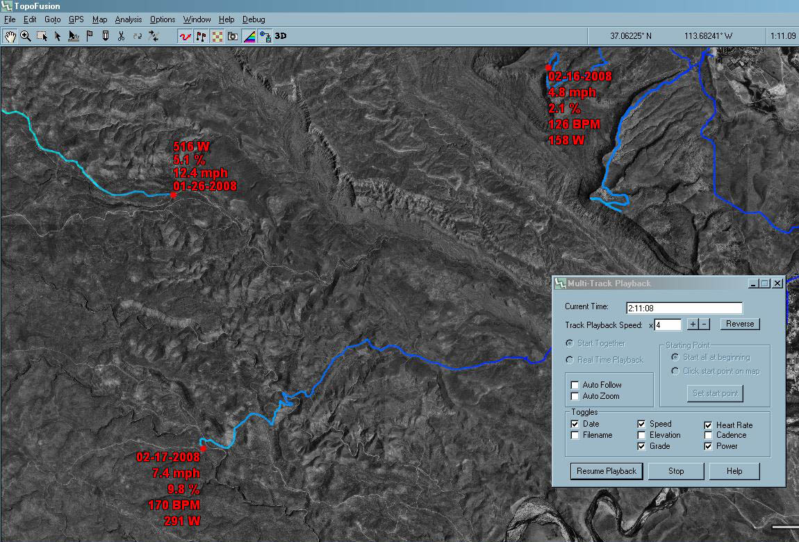
http://topofusion.com/beta.php

The first major change is an update to the Multi-track playback system.  "Real time stats" -- shows all manner of current stats, per track.  This is a really cool way to visualize multiple tracks and compare rides/runs/whatever.

Below (next post) is a screen grab from a few of my files, including power meter data.

----

Even just the addition of the date and/or filename fields is a great help in differentiating tracks as they go.  You could always change the color and add "Author" fields, but that took time.  This is automatic.  Automatic is good.

I've already discovered that 5/23/2004 was the fastest date I ride my local mountain bike route.  Funny to watch that day shoot ahead of the ~200+ other tracks!

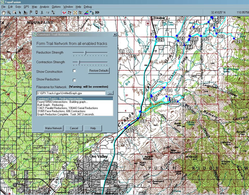
Also, I've finally dug back into the GPS Network code!!  This is long awaited, and I certainly apologize for the delay.

Most importantly, I believe I have squashed the nasty little bug that would crop itself with certain geometric arrangements of tracks.  

The reduction phase of the process has also been ridiculously sped up.  I didn't think this one optimization would have such a profound effect, but in one test case the total time for network creation went from 60 seconds to 20 seconds.  In many cases the reduction was the slowest part of the process, so this is a huge improvement.

----

The UI has been updated as well, with some informative messages.  

Throw as many tracks as you've got at it and let's see if we can get it to crash.

Complete list of changes:

3.36 - [6/06/08] (Beta)

Added speed/hr/cad/power/elevation/date/grade/filename displays to Multi-track                          
    playback (stats follow current position of each track)
Added "reverse" speed button to Multi track playback
Added "mouse wheel speed" (zoom amount) setting to Preferences->Tilesets
   (controls how much one scroll of mouse wheel zooms)
Added "fine tune" zooming - hold CTRL down with mouse wheel or '+' or '-'  
Added "Send to GPS..." option to right click context menu
    (faster access for uploading files)
Vastly improved speed of Network creation (Graph Reduction phase)
Fixed geometry-specific bug in postContract() phase of Make Network
Improved Network output - additional serial/parallel phase
Fixed time data issues in networks
Added "..." (save as) file chooser to Make Network dialog
Added status display window to Make Network dialog
Fixed problem with track splitting (for upload) after simplifying a track

3.35 - [6/02/08] (Beta)

Fixed longstanding intermittent crashes in MAKE NETWORK code!
Removed "saving power/hr/cad to GPX" warning on Make Network
Added ability to reverse multi-track and single track playback
   (negative speed multipliers are allowed)
Added interpolated elevation field to Lap Analysis .CSV export
Fixed multi-track and single track playback speed multipliers to be
   consistent with real time
Improved handling of zero lat/lon (non-locked) NMEA live tracking
Fixed bug causing time data not to be loaded in eXplorist .LOG files
  (and Timex .txt exports)
Fixed bug causing main TF window to become tiny when un-maximizing
In progress - speed, elevation stats shown on screen in multi-track playback

3.34 - [4/28/08] (Beta)

Added "Garmin Astro" tracking to live tracking.  Continuously
   downloads tracks from the GPS.
Uploaded saved tracks now preserve track name (if present)
Downloaded saved tracks names now preserved
Track name now shown in profile window, if existing
Added "Add file to Logbook" to right click file menu
Fixed average cadence computations to not include coasting
Fixed missing baud rate with Magellan units in GPS Transfer dialog
Removed NMEA tracking debug info

1539
GPS, Trails, Training / Win a free copy of TF!
« on: May 22, 2008, 04:23:12 PM »
Codes sent!  Let us know if you didn't get them!

Thanks again!

1540
GPS, Trails, Training / Lightweight Touring
« on: May 22, 2008, 04:22:24 PM »
Check out this thread on MTBR on lightweight touring by Mike Curiak:

http://forums.mtbr.com/showthread.php?t=410393

It's chock full of amazing photos and some accompanying text.  The theme: ultralight bikepacking.  

TopoFusion author Scott Morris was a part of most of those trips, and contributes a few writeups and pictures as well.  But it's mostly Mike's show.

1541
GPS, Trails, Training / Win a free copy of TF!
« on: May 22, 2008, 04:06:04 PM »
Hi All,

Sorry for the delay in choosing a contest winner.  Part of it was that I was still out on the trail when the contest ended.

But the biggest delay was that it was hard to choose a winner!!  I really enjoyed reading all of them.  All were very unique and interesting in their own way.  It's always very rewarding to see the different ways TopoFusion is being used.

I liked them so much that I'm upping the discount for all entries - to a 25% code (will be emailed to everyone shortly).

But the winner is...

CD's story of exploration on the Navajo Res.  Great pictures and accompanying text.  I think I have a soft spot for adventures that are off the beaten path, and nameless signless roads on the res are tough to beat in that category.

ED - very interesting about the guzzlers.  I ran into one of those in the New Mexico backcountry this past weekend.  It was fenced off to keep cattle out, but had a little pump into a trough especially for wildlife.  Very cool shot of the coyote.

Libor - very cool to have an international entry.  I was very interested to see someone using the program from outside the US.  Feel free to send any suggestions about PhotoFusion our way - and thanks much for the help getting the word out about TF.

Ergin - I already commented above about your cool story.  I've ridden a bit in that area, and hope to get back to ride some more.

Brian - Great work with TF and video walk-thrus, as usual.  Keep up the cool work!

Thanks everyone for taking the time to write up your stories!

1542
TopoFusion on other OS - Mac / Linux / TF Pro on VMWare Fusion
« on: May 21, 2008, 03:09:04 PM »
I just got an email from Ross Z.  He reports that TF Pro is working well under VMWare Fusion 2.0 beta.

That's great news for Mac fans.

Feel free to chime in with your experience using VMWare Fusion here.

1543
Feature Requests / Tape measure
« on: May 19, 2008, 09:38:38 AM »
I'll have to check what the tape measure does in GE, but you can use the draw (pencil) tool in TF to measure distance, either straightline or along a polyline.

Further, if you draw a ~polygon with it you can then save it out to a GPX file, right click on the track and do "compute area."  This could be made more obvious, but the functionality is there.

The only thing you can't do is shade a polygon.

Hope that helps.

1544
TopoFusion Anouncements / Out on the bike til May 19th
« on: May 12, 2008, 07:25:03 PM »
Hi,

I'm heading out to bikecamp across parts of the Grand Enchantment and Continental Divide trails in New Mexico.

A map and a few words about the route are here:

http://www.topofusion.com/diary/

Forum and email responses will be delayed until I get back, likely May 19th.

Thanks for the patience.

Scott

1545
Many of you know that TopoFusion is a shareware product -- the demo version is free to "share" and if you want to unlock the software's full potential, you can pony up for the registered version.

I came across something pretty remarkable this week: sharehardware.  How does it work?

You send an email requesting a GPS cable and give a pledge amount (any amount).  When you get the cable you can mail a check back, or not!  Simple, eh?

It's quite a concept.  Even better is that the cable offered - (compatible with most Garmin USB units - VistaHCX, Edge, 60CS, etc) - is a pretty cool one.

As it shows on this page:

http://www.pfranc.com/Garmin-USB-Cables/

The cable weighs half an ounce.  When I got it I was surprised how small and light it is.  Who wants a light GPS cable?  Travelers, and more specifically, backpackers and bikepackers.

I've carried the Garmin cable on more than a few trips, and when you're carrying every ounce of your gear up every single hill, weight matters!

So, this is a pretty cool cable.  Head on over to Larry's site and try out share-hardware.  I got my cable a few days later and have already mailed back a check for $10.

1546
TopoFusion Pro / colorado 400t
« on: May 09, 2008, 09:21:48 AM »
Hmm, that's strange.  I still don't quite understand what happened.

Can you send me the .gpx and .upt files in question so I can take a look?

smorris@topofusion.com

Thanks.

1547
GPS, Trails, Training / Win a free copy of TF!
« on: May 08, 2008, 08:08:15 AM »
Nice report!  All the ingredients of an epic ride - exploration, length, climbing, going the wrong way and fun little quirks like the truck and landing strip.

Very cool, thanks for sharing.


(15% code sent, and you're the front runner for a free copy!  '<img'>)


1548
TopoFusion Pro / colorado 400t
« on: May 07, 2008, 10:09:49 PM »
Moving to TF Pro forum.

1549
TopoFusion Pro / colorado 400t
« on: May 07, 2008, 10:09:14 PM »
Well, every file downloaded from a GPS will be saved by TopoFusion into the "backup" directory.  But the Colorado circumvents that procedure so unfortunately there's no backup.

But I'd do a system wide search for all .gpx files and see if the file ended up somewhere else.  Also make sure the waypoint toggle isn't just off or something like that.

What does the gpx file look like when you open it up?  No waypoints and no track points?!

1550
GPS, Trails, Training / Win a free copy of TF!
« on: May 07, 2008, 09:30:32 AM »
Funny - no ride reports so far.  Yet we've had several people buy copies of TF since the announcement.  I guess it does take some effort, or perhaps folks are too shy?  


Anyway, here's a recent ride (a rare shuttle ride for me, I'm no downhiller):

*------------*

A week ago I hadn't ridden Green Mtn for over a year.  What's wrong with me?

Now I've ridden it three times and am gunning for more.


Max has an obsession with the trail (and shuttling it).  


With good reason.


Good old fashioned hike-a-bike.


I bumped into none other than Steve Wishart on Sunday's high spirited cruise around Starr Pass.  He was easy to talk into the shuttle ride.  Steve is an old friend from the UA cycling team.  He and I went to Sandpoint, ID to race collegiate nationals together, among other adventures.


BMX'ers know how to jump.  They need to learn how to use front brakes, though.


Climbing 'the scar'.  The kid gave it a great effort.  I think it'll be cleanable once we get some rain.


After singing praises of the Leviathan, I'm ready to do the same on the Behemoth.

Which bike is my favorite?  Whichever I last rode.


Green, Bugs, Molino.  Self-indulgent cinco de mayo / birthday shuttle ride.  Then a late dinner at an empty but oh-so-tasty mexican restaurant with Paula.  Hard to imagine better ways to celebrate.... being alive.

Pages: 1 ... 29 30 [31] 32