Show Posts

This section allows you to view all posts made by this member. Note that you can only see posts made in areas you currently have access to.


Messages - ScottMorris

Pages: 1 ... 28 29 [30] 31 32
1451
Beta Testing / Edge 705 no communication
« on: October 05, 2008, 01:59:47 PM »
Mike,

Loading .tcx files should work.  Which version do you have?  If you haven't updated for a while .tcx capability wasn't there.

Upgrade to the latest (full version, not beta) -- v3.51 now supports direct download from Edge 705 units.

Please let us know if you still have problems.  Thanks.

1452
TopoFusion on other OS - Mac / Linux / TF Pro on VMWare Fusion
« on: October 04, 2008, 09:57:08 AM »
I just received this from a customer:

Quote
I think you'll be pleased to know VMWare has worked out the kinks in
Fusion and 2.0 now runs TopoFusion without crashing.  The support for
DirectX 9c is pretty remarkable and it's very responsive.


Sounds like VMWare is the way to go!  Awesome!

1453
TopoFusion Pro / Problem with Live tracking and NO MAPS.
« on: October 03, 2008, 02:52:59 PM »
Don't worry, I believe you that there is a bug.  I'm just having trouble duplicating it, and trying to make sure the map position just isn't moving.

So when you do live tracking do you use the "Center map on position" feature?

If so (and I'd think you do), then the icon is always in the center of the screen, if the GPS is reporting a position 5000 miles from the last known position, right?

I definitely got both GPS units I tested with to lose all signal.  Not hard to do with older Garmin units when indoors.  What I have not done is test it while actually moving, in a car.  I suppose that is the next avenue to explore since I can't get it to do anything while stationary.

One question about when you need to reinstall.  This really sounds like you're getting your map position moved to Africa or something.  When you're outside the US you will get no maps in topo or aerial.  Did you note the coordinates being reported when you move the mouse around?  Are you sure you were still in the US?  If you switch to Landsat, you should see where in the world you are, and it's easy to zoom out and pan back.  Or, double click on a file to auto zoom/pan the map to show that file back in the US.

Sorry for all the questions, I just still suspect that the position is moving somewhere bogus.  I'll quit with it if you can answer those above, and will change my thinking.

1454
TopoFusion Anouncements / Pro version 3.51 Released!
« on: October 03, 2008, 02:42:57 PM »


We're pleased to announce the release of version 3.51 of TopoFusion Pro.

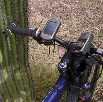
The latest revision adds direct support for the newest Garmin GPS units, like the Edge 705, Colorado, Oregon (shown above, mounted to handlebars) and Nuvi.  These are the new "mass storage" device GPS units.  TopoFusion has always supported them in that it loads and saves GPX and TCX files.  But now you don't need to do your own file management and be unsure if you got things into the correct directories -- let TopoFusion handle it for you.

The new units are supported just like older USB and serial units are -- direct transfer of tracks and waypoints.  We've also added a few little tricks like auto-naming of tracks based on the filename.  This prevents every track from being named "Tracklog" (the default if the track has no name field).

Also in this release is more Windows Vista friendly install and directory structure.  Existing users won't notice any change -- settings and default directories will remain the same.  New installs will now use "My Documents\My TopoFusion Files" by default, rather than storing everything in "Program Files."  This avoids the compatibility mode issues and the storing of files in the "Virtual Store."

Download Link: Download TopoFusion

Full list of changes since v3.41:

3.51 – [10/03/08] (Full Release)

Separated transfer of waypoints and tracks for Garmin mass storage devices
(e.g. Edge 705, Colorado, NUVI, Oregon).
GPS transfer dialog now behaves the same for Garmin USB and Mass storage
Added track names (based on filename, and only if empty) to tracks upon upload
to mass storage devices.  Now on Colorado/Oregon units uploaded tracks
will have names, rather than “Track log.”
Fixed crash unloading a newly downloaded file after using “Save all” command.

3.50 – [09/24/08] (Beta only)

Added direct upload support for Garmin mass storage devices
(e.g. Edge 705, Colorado, NUVI, Oregon series)
Updated Installer and default directories to be more Windows Vista friendly
Fixed double .INI file problems on Vista
For new installs only:
* Default tracks directory now “My documents\My TopoFusion Files”
* TopoFusion.ini and TopoFusion.log stored in “AppData\Local\TopoFusion”
Existing installs:
* Default tracks dir remains the same
* Current TopoFusion.ini file will be loaded, whether in
C:\Program Files\TopoFusion or in the “Virtual Store.”
* TopoFusion.log stored in “Appdata\Local\TopoFusion”
TopoFusion will now run without admin privileges on XP/Vista
(still need admin to install)
Installer now asks to run *after* closing
Fixed problems loading some NMEA .log files

3.42 – [09/10/08]  (Beta only)

Added direct download support for Garmin mass storage devices
(e.g. Edge 705, Colorado, NUVI, Oregon series)
Changed default filename for downloaded tracks to YYYY-MM-DD
Downloaded “saved tracks” now default to their name if saved

1455
TopoFusion Anouncements / Basic v2.975 released
« on: October 01, 2008, 11:33:52 AM »


Today we released a new revision of TopoFusion Basic -- version 2.975.  This version includes several bug fixes and some additional functionality.

Smart merging is a great new feature that really simplifies track merging.  Trailing extra points on drawn tracks was another really nagging UI issue that has been resolved.

We tried a couple approaches to get Landsat tiles to download again in the Basic version, but it just isn't possible.  The way Basic talks to the Nasa server simply isn't supported anymore.  If you want new Landsat tiles, you will have to upgrade to the Pro version of TopoFusion, which besides working, downloads much faster than Basic ever did, and stitches them together much more seamlessly.

If you're using Basic and have existing Landsat maps already downloaded they will continue to work.  But we have disabled the code that tries to download tiles and replaced it with a (one time) error message.

Other changes, from the revision history:

2.975 – [10/01/08]

Fixed crash in "edit track properties" when editing info
Fixed intermittent “unknown exception” on finishing track download
Fixed bug causing main TF window to become tiny when un-maximizing
Added “smart” merging (track merge tool)
  - also: holding shift is no longer required to merge
Fixed problem with stray point added to end of drawn track
Fixed crashes loading some network files (removed maketopology()).
Updated copyrights on splash and about
Disabled Landsat tiles by default, added error message indicating new landsat downloads non-functional (Existing downloaded landsat tiles will still load and display)

-------

Thanks!

1456
TopoFusion Basic / New release - v2.975
« on: October 01, 2008, 11:30:36 AM »


Today we released a new revision of TopoFusion Basic -- version 2.975.  This version includes several bug fixes and some additional functionality.

Smart merging is a great new feature that really simplifies track merging.  Trailing extra points on drawn tracks was another really nagging UI issue that has been resolved.

We tried a couple approaches to get Landsat tiles to download again in the Basic version, but it just isn't possible.  The way Basic talks to the Nasa server simply isn't supported anymore.  If you want new Landsat tiles, you will have to upgrade to the Pro version of TopoFusion, which besides working, downloads much faster than Basic ever did, and stitches them together much more seamlessly.

If you're using Basic and have existing Landsat maps already downloaded they will continue to work.  But we have disabled the code that tries to download tiles and replaced it with a (one time) error message.

Other changes, from the revision history:

2.975 – [10/01/08]

Fixed crash in "edit track properties" when editing info
Fixed intermittent “unknown exception” on finishing track download
Fixed bug causing main TF window to become tiny when un-maximizing
Added “smart” merging (track merge tool)
  - also: holding shift is no longer required to merge
Fixed problem with stray point added to end of drawn track
Fixed crashes loading some network files (removed maketopology()).
Updated copyrights on splash and about
Disabled Landsat tiles by default, added error message indicating new landsat downloads non-functional (Existing downloaded landsat tiles will still load and display)

-------

Thanks!

1457
TopoFusion Pro / Resolved Issue - 3D on new ATI Cards
« on: October 01, 2008, 08:19:42 AM »
Quote (ScottMorris @ May 04 2008,10:02)
Right now all revisions of TopoFusion Pro have a problem with certain ATI video cards (examples: ATI Radeon HD 3400 Series, ATI Radeon HD 2400 Series).  The problem is that the 3D model appears black, though 3D tracks and waypoints work OK.

At present this appears to be a driver issue, not a bug in TopoFusion.  A ticket has been opened with ATI and we will continue to monitor this.

Please note, this only applies to 3D mode -- 2D and all other functionality is working 100%.

Thanks for the patience.

This is no longer an issue - the latest ATI drivers (release 8/20/08) have fixed the problem.

Seems it was a driver issue all along.

1458
Beta Testing / 3.50 - Garmin Mass Storage, and Vista stuff
« on: September 30, 2008, 07:33:58 AM »
Anyone have able to test Edge 705, Colorado, Oregon, or Nuvi?

We'd really appreciate any positive or negative reports on downloading / uploading tracks with these units.

Thanks!

1459
Beta Testing / 3.50 - Garmin Mass Storage, and Vista stuff
« on: September 30, 2008, 07:33:12 AM »
Thanks Larry.  Yeah, I get the inverted L's too now for some reason.  

I'm planning on replacing the lower "active list" with a different control (one that shows multiple tracks per file).  So I'm not going to worry about the boxes just yet.

1460
TopoFusion Pro / Problem with Live tracking and NO MAPS.
« on: September 30, 2008, 07:31:54 AM »
How do you know that it's not moving the position temporarily?

Do you have tracks in the area that stay on the screen?  Or does your current "live track" stay on the screen, exactly relative to where you were before?

Sorry for questioning it, but I know my software fairly well, and there's not much that can cause "downloading" tiles to appear, other than actually being in a area/tileset that hasn't been downloaded yet, or doesn't exist.

I will try again to duplicate it.

1461
TopoFusion Pro / Problem with Live tracking and NO MAPS.
« on: September 28, 2008, 10:35:10 PM »
Hmm.

I also forced a loss of satellite and it continued to report the same position (and show maps).

I will try it again.

In the next beta I will build in a failsafe that prevents bogus lat/lons from being reported.  My guess is that your GPS is reporting differently than mine when it loses sats.

While I'm there I will look at signal strength in NMEA and see if I can add it to the dialog.

Thanks.

1462
TopoFusion Basic / Problem creating OpenGL
« on: September 26, 2008, 05:46:56 PM »
Topic moved from archived support on 9/26/08.

1463
TopoFusion Basic / Problem creating OpenGL
« on: September 26, 2008, 05:46:04 PM »
It's both a TopoFusion and a driver issue.  TF Basic's 3D works just fine if your video card can handle relatively large textures (i.e. isn't several years old).

Sounds like maybe you were using the demo for TF Pro, then bought the Basic version?  The 3D code is completely different between the two versions, and Pro doesn't have the same limitation.

It's confusing, I'm sorry.  Did you try updating video drivers?  What video card do you have?

BTW, I am going to move this thread to the TopoFusion Basic forum, since this forum is technically closed.  Please look for it there.

Thanks.

1464
Beta Testing / 3.50 - Garmin Mass Storage, and Vista stuff
« on: September 25, 2008, 08:54:54 AM »
TopoFusion beta v3.50 is out.  New stuff:

  • Download/Upload for newer Garmin units that use the 'mass storage mode' to transfer GPS data.  You could always manually navigate to the appropriate directory and open files from an Edge 705, Nuvi, Colorado, etc.  But now the GPS dialog in TF will open the files and give the familiar "Download/Merge Tracks" dialog.

    If you have any of these units, please test this and let us know how it goes.  We don't own all of these units and would sure appreciate some additional testing.

  • Vista issues.  Windows Vista doesn't like it when a program tries to create and write files in C:\Program Files\TopoFusion.  It lets the software do it, but it goes into the "Virtual Store" AKA "Compatability Files."  This gets confusing, and was made even worse by the fact that if you answered "Yes" to "run topofusion?" at the end of the installer, you are running with admin access, so you can write in Program Files.  So you could get two different settings of TopoFusion this way.

    TF is now more Vista friendly.  That means we use the "My Documents" directory as the default for tracks and maps.  Also we use the (local) "App data" directory to store the .INI and .LOG files.  

    That said, we took care to make sure it was backwards compatible with existing TF installs.  If you are using settings stored in C:\Program Files you will still get them, and it will continue to use it (whether you are using Vista or not).  

    For existing users the details aren't all that important -- the key thing is that nothing should get reset -- you should get your same settings, maps, default tracks, directories as before, just by installing TF on top of your current install. Please let us know if you notice anything strange!  It might also be a good idea to backup your TF directory.  But everything should really be fine.


    Full changes from the revision history:

    3.50 – [09/24/08] (Beta)

    Added direct upload support for Garmin mass storage devices
    (e.g. Edge 705, Colorado, NUVI, Oregon series)
    Updated Installer and default directories to be more Windows Vista friendly
      Fixed double .INI file problems on Vista
    For new installs only:
      * Default tracks directory now “My documents\My TopoFusion Files”
      * TopoFusion.ini and TopoFusion.log stored in “AppData\Local\TopoFusion”
    Existing installs:
      * Default tracks dir remains the same
      * Current TopoFusion.ini file will be loaded, whether in
        C:\Program Files\TopoFusion or in the “Virtual Store.”
      * TopoFusion.log stored in “Appdata\Local\TopoFusion”
    TopoFusion will now run without admin privileges on XP/Vista
       (still need admin to install)
    Installer now asks to run *after* closing
    Fixed problems loading some NMEA .log files


    3.42 – [09/10/08]

    Added direct download support for Garmin mass storage devices
    (e.g. Edge 705, Colorado, NUVI, Oregon series)
    Changed default filename for downloaded tracks to YYYY-MM-DD
    Downloaded “saved tracks” now default to their name if saved


  • 1465
    TopoFusion Pro / Merging into an existing network reduces data
    « on: September 24, 2008, 09:50:02 AM »
    Ha!  Using anything but TF is pure blasphemy!

    Only joking.  All the various mapping solutions have their advantages and disadvantages, IMO.

    Thanks for running the numbers.  We did a similar calculation some years ago and came to the same conclusion.  

    For reference, the GPX files written out by Garmin themselves (on the SD card) also use only 6 digits of precision.

    Now, when you start talking about averaging and splitting tracks there might still be some argument to adding a few more digits.  But I'm inclined to think it's overkill.  If points really are that close you may as well eliminate them as duplicates both to save disk space and also processing time (for a network calculation especially).

    Thanks for the thoughtful discussion.

    1466
    TopoFusion Pro / Merging into an existing network reduces data
    « on: September 23, 2008, 03:01:09 PM »
    That sounds correct.  What software did the original files come from?

    TopoFusion does only write out six digits of precision (it reads in as many as are there and stores things as doubles).  I remember thinking about this issue a long time ago.  It may be worth revisiting.

    It increases the file size of a GPX by a fair amount (going to 12), but disks are cheap these days, and bandwidth too.  I don't think the average user is going to notice any difference in the look or stats of their tracks, but for some of the more sophisticated features, like the network, it might make sense.

    Any thoughts?

    1467
    TopoFusion Pro / Problem with Live tracking and NO MAPS.
    « on: September 23, 2008, 02:49:20 PM »
    No, I haven't been able to duplicate the problem, so I don't know how to fix it.

    When I use NMEA live tracking I can happily move the map around as much as I want and I always have the maps I downloaded.  It never goes somewhere that doesn't have maps.

    I have tried both with and without "Center Map on Position" checked.

    It's very unlikely that you are actually "losing the maps", but I could see it getting a bogus position that it's centering the map too, and it's somewhere outside the US where there are no maps.

    Can you send me your current .INI file so I can see if there might be a different setting somewhere?

    Just so we're on the same page:

    1 - hit "start tracking"
    2 - leave "Center Map on Position" checked
    3 - Go to the map window and pan away from current position.
    4 - map goes blank

    Right?

    Thanks.

    1468
    Feature Requests / Give us your ideas for improving TopoFusion
    « on: September 23, 2008, 09:42:00 AM »
    Quote (WVHunter129 @ Sep. 23 2008,8:49)
    Printing needs to be more user friendly with options to select print/paper size.  I like to print to the a plotter so I can get 11x17 or 24x36 inch, etc. size drawings that shows all the terrain that I have covered while riding my ATV or to show all the boundary of my hunting lease.  Yes I can do that on an 8-1/2x11, but no detail because of having to zoom out so far to see the entire trail or he entire hunting lease boundary.  Adding options to print size would be a big benefit to the software.

    Yep, printing functionality needs to be expanded.

    Right now the recommended strategy is to export to high resolution, then use a graphics program to print the resulting image (constrained to whatever paper size you want).

    Thanks for the suggestion.

    1469
    User Projects / IBPindex project
    « on: September 19, 2008, 09:41:12 AM »
    Cool, it looks similar to TopoFusion's Difficulty Index.  I will have to give it a closer look and get in contact with the authors.

    Thanks for the link.

    1470
    TopoFusion Pro / Merging into an existing network reduces data
    « on: September 19, 2008, 09:38:46 AM »
    Alright, I had a look at your files this morning and here is what's going on.

    The original network, for some reason, has a lot of duplicate points.  As in, even in floating point, they are exactly the same.

    The first step of the network algorithm, when combining files, is to eliminate any (successive) duplicate points.  An easy way to speed things up, and they can mess up some geometric calculations too.

    Note that the first line of the network output says there are only 14,656 points -- that's after eliminating duplicates.

    So, in other words, there's nothing to worry about.

    Now, the question is, how did the duplicate points get there in the first place?  Is this a network you have been adding to successively?  If so, how times do you think you've added to it?

    1471
    TopoFusion Pro / Problem with Live tracking and NO MAPS.
    « on: September 10, 2008, 08:05:56 PM »
    On the first point, how are you moving the map?  With the mouse (drag/pan) or keyboard arrows or?

    I've done that many times and never had it go to a bogus location.

    Hmm.

    What coordinates does it go to when it's messed up?

    1472
    TopoFusion Pro / Resolved Issue - 3D on new ATI Cards
    « on: September 05, 2008, 11:26:37 AM »
    This error either indicates something wrong with your video card's drivers, or that the video card is running out of memory for some reason.

    Have you been able to successfully run TopoFusion before?  Or has it always done this?  It may be that your card doesn't have enough memory to run in full screen (maximized) mode.

    Can you send the file 'Topofusion.log' to support@topofusion.com?  That'll help us see what's going on.

    There's no 2D-only mode, unfortunately, but that error indicates a problem initializing the 2D aspects (which are actually done using Direct3D, even though there's no 3D to it).

    Thanks.

    1473
    TopoFusion Pro / Proxy authentication?
    « on: September 02, 2008, 04:53:27 PM »
    No, not in the current version.  It's getting to be time to get this rolling, though.

    1474
    TopoFusion Pro / Waypoint Text Box Solid Color
    « on: August 31, 2008, 08:45:24 PM »
    Thanks for following up on the issue.  It definitely sounds like a driver issue.

    1475
    GPS, Trails, Training / GPS Data Editing Software
    « on: August 20, 2008, 08:45:03 PM »
    Ah, I see what you mean about the white spaces.  I don't know of any solution for it, sorry.  It's on the source imagery, so... hmm.

    1476
    GPS, Trails, Training / GPS Data Editing Software
    « on: August 20, 2008, 05:52:10 PM »
    There's an option for "All Urban" in the tileset dropdown.  That's likely the one you need.

    1477
    GPS, Trails, Training / GPS Data Editing Software
    « on: August 20, 2008, 04:12:20 PM »
    If you find the right preset for your area, please let us know so we can add it as a default.

    Go to "Lap Analysis."  Instead of 'fixed interval' choose "lap analysis."

    This should break things up into laps, assuming you returned to the start of your track.

    1478
    GPS, Trails, Training / GPS Data Editing Software
    « on: August 20, 2008, 03:41:01 PM »
    One thing you can do is use the "map offset" feature in TF.

    You should be able to find the correct offset and simply offset only the urban tiles.  This might make more sense than offsetting the data.

    Otherwise I'd recommending exporting to .txt with TF, then doing the offset with a text file rather than GPX.  You'd lose the time data this way, though.

    Not sure what laps you want to split out.  Times where you hit the 'lap' button, or just when the track comes back to the same spot?  There's a bit of functionality to detect laps in TF right now, but you can just export each one, not split into GPX files.  Using the scissors you should be able to do it, though.

    1479
    TopoFusion Anouncements / v3.41 Released - Australian Topos
    « on: August 20, 2008, 09:31:32 AM »
    We're pleased to announce the release of a new version of TopoFusion.

    The biggest addition to this version is access to topographic maps for all of Australia:


    http://www.topofusion.com/news/wp-content/uploads/2008/08/aus_sample1.jpg'>


    For more details on these maps see available imagery.  We're excited about this addition since it has been a long requested feature, and we have a few potential projects in OZ as well.  Find the Australian maps paired with the Canadian Topo tileset -- there's no overlap so they share the same tileset.

    The other major addition is "GPX styles."  This allows users to set and display attributes such as width, color, opacity and patterns to GPS tracks and drawn lines.  This is a great improvement for map making, and is especially useful for Trail Networks.  


    http://www.topofusion.com/news/wp-content/uploads/2008/08/linestyles.jpg'>


    To change these settings, right click on a track in the map window and choose "Track Properties".  The dialog looks like this:


    These attributes are saved in the "GPX styles" schema, an extension to the GPX format that is supported by several other mapping programs.

    Full list of changes since v3.39:

    3.41 – [08/15/08]

    Cut tracks now inherit the original track’s color/width/pattern/etc
    Fixed File Properties to only apply color to all tracks when color is
       actually changed
    Fixed bug when merging tracks while download box or drawn track is active

    3.40 – [08/12/08]

    Added Australian Topo Map server!
       Covers all of Australia
       Shares tileset with Canadian topo – “Can Topo” now “Can/Aus” tileset.
       Can/Aus downloads Canada Topo in northern Hemisphere, Aus Topo in southern
    Added support for GPX_style extension (also KML Styles)
    Added per track line width
    Added per track coloring
    Added per track opacity
    Added per track pattern (dash/dot, et cetera)
    Added track names to KML exports
    GPX files now saved as GPX 1.1
    Drag and Drop of files now supported for main map window
      (previously only active file list could be dropped into)
    Fixed synchronization issues between profile/simplify/waypoint/track dialogs
    Fixed infinite loop with large GIS waypoint files, skipping at high zoom levels
    Fixed false clipping for long track segments
    Fixed problem reloading tiles when clicked outside current UTM zone

    1480
    Feature Requests / Non-US Mapping
    « on: August 15, 2008, 11:44:04 AM »
    Support for that server is now available in v3.41 -- the latest beta.

    See the beta forum for details:

    http://tinyurl.com/35z3e6

    1481
    Beta Testing / v3.41 - Australian Topos, Line styles
    « on: August 15, 2008, 11:37:52 AM »
    Other changes / fixes are in the release notes:

    3.41 – [08/15/08]

    Cut tracks now inherit the original track’s color/width/pattern/etc
    Fixed File Properties to only apply color to all tracks when color is
       actually changed
    Fixed bug when merging tracks while download box or drawn track is active

    3.40 – [08/12/08]

    Added Australian Topo Map server!
       Covers all of Australia
       Shares tileset with Canadian topo – “Can Topo” now “Can/Aus” tileset.
       Can/Aus downloads Canada Topo in northern Hemisphere, Aus Topo in southern
    Added support for GPX_style extension (also KML Styles)
    Added per track line width
    Added per track coloring
    Added per track opacity
    Added per track pattern (dash/dot, et cetera)
    Added track names to KML exports
    GPX files now saved as GPX 1.1
    Drag and Drop of files now supported for main map window
      (previously only active file list could be dropped into)
    Fixed synchronization issues between profile/simplify/waypoint/track dialogs
    Fixed infinite loop with large GIS waypoint files, skipping at high zoom levels
    Fixed false clipping for long track segments
    Fixed problem reloading tiles when clicked outside current UTM zone

    1482
    Beta Testing / v3.41 - Australian Topos, Line styles
    « on: August 15, 2008, 11:36:36 AM »
    v3.41 is ready for beta testing.  Find it in the usual place:

    http://topofusion.com/beta.php

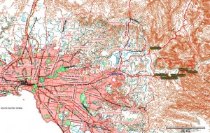
    The first big change is a new map server!  Australian topo maps!

    Sample image from the Melbourne area:


    Sample at a smaller scale:


    We're very excited to offer automatically downloaded Topo maps for all of Australia!

    Note that the Canadian Topo tileset is now the CAN / AUS tileset.  Since Canada and Australia don't overlap they share a tileset.  In the northern hemisphere TF will download from the CAN server, and in the southern it's the AUS server.

    -----------------------------------------


    The other big change is per line styling.  Now individual tracks within a single GPX (or kml) file can have different colors, widths, opacities and patterns (dashed, dotted, etc).

    This required moving to GPX 1.1 (previously TF was using 1.0), and it was about time to join the newer standard.  So we spent some extra time testing things since the "bread and butter" GPX saving routines had some changes.

    Really there's nothing to major between 1.0 and 1.1.  But we can now use the GPX_Styles extension to get colors, widths, etc.

    Screen shot:


    That shows a little bit of what can be done.  The good thing is that this is all stored in a standard way that can be read by several other GPX programs.

    To change a track's style you need to right click on it and choose "Track Properties."  You'll get this dialog:


    Pretty self explanatory.  The old way of changing colors
    per file still works and is in the File Properties dialog, but be careful since it change every track in your file to that color.

    We'll have more features related to this in future versions.  For example, settings for what you want your default track to look like.

    1483
    TopoFusion Pro / no time data...magellan explorist
    « on: August 12, 2008, 09:06:44 PM »
    No problem, I should have asked the version first -- sorry 'bout that.

    1484
    TopoFusion Pro / no time data...magellan explorist
    « on: August 11, 2008, 08:22:38 PM »
    Yep -- try upgrading to 3.39 and let me know if it works or not.

    1485
    TopoFusion Pro / no time data...magellan explorist
    « on: August 10, 2008, 01:46:45 PM »
    Matt,

    I checked out your file and the time data is there for me.

    What which version number of TopoFusion are you using?

    Thanks.

    1486
    TopoFusion Anouncements / Version 3.38 Released
    « on: August 05, 2008, 08:26:47 PM »
    Yep, it's been on the list for a while -- finally got to it!

    I believe the font specs are the same as the general waypoint font -- so try changing that.

    It'd be nice to have two settings, but not super critical at this point.

    1487
    Feature Requests / Non-US Mapping
    « on: July 31, 2008, 01:33:47 PM »
    Awesome, this looks very likely to work for TF's purposes.  Thanks much for the link!

    I will experiment with it and see if we can get it rolling.

    1488
    TopoFusion Pro / no time data...magellan explorist
    « on: July 30, 2008, 04:21:43 PM »
    Correct, Nick meant Garmin, not Magellan.

    The loss of time data is not a design feature on Magellan units.  The files you import to TopoFusion do have time data in them, it just seems that there is some problem reading it on your files.

    There's no way to get the "active log" from the eXplorist units -- they simply don't speak the same protocol that the sportrak units do.  You have to copy the files off the removable hard drive that comes up.

    1489
    Feature Requests / Give us your ideas for improving TopoFusion
    « on: July 29, 2008, 11:48:48 AM »
    I see what you mean.

    This is definitely a Terraserver issue.  They have a bad offset or a bad map in there.

    Unfortunately there isn't that much we can do about it.  There is a "map nudge" feature that you could toggle on and off when using that area.  This is assuming you can figure out the correct offset (probably need some GPS data in the area to do this).  

    Sorry about the issue.  I'd suggest contacting Terraserver to see if they are aware of the issue in that locale.

    1490
    TopoFusion Anouncements / Version 3.38 Released
    « on: July 28, 2008, 09:29:02 PM »
    Today we released a minor revision to the current release.

    Version 3.39 is now out and includes a bug fix for reading certain types of GPX files.


    1491
    TopoFusion Anouncements / Version 3.38 Released
    « on: July 27, 2008, 01:21:46 PM »


    We're pleased to announce the release of version 3.38 of TopoFusion Pro.

    Released in both demo and registered versions, this new version offers a host of new features and improvements.

         
    • Multi-track playback is now much more exciting with the addition of "on screen" stats.  Choose from an array of stats to display, per track, as the simulation rolls on.  Some examples are: speed, elevation, grade, heart rate, power, file date.


    •    
    • Directional arrows - a new toggle on the tool bar controls whether small arrows are automatically drawn on GPS tracks, showing their direction.  Very useful for producing maps but moreso, just understanding your GPS data!


    •    
    • GPS Networks - Major improvements in the network algorithm have been released in this version.  The interface has been upgraded, a huge increase in network reduction speed, lower memory overhead and several bug fixes are just some of the improvements.


    •    
    • Live tracking - Improvements here include a special tracking mode for Garmin Astro users, periodic saving of the recorded track to disk and better NMEA GPS unit support.


    •    
    • User interface - Additional features like right click disambiguation, "highlight track in active list", "send to GPS...".


    For full details on all changes, see the Revision History.


    1492
    Feature Requests / Import *.gdb files
    « on: July 27, 2008, 01:18:50 PM »
    Thanks for the suggestion.

    Just curious why -- Mapsource can open/save GPX, so I always use it to convert any .gdb files.

    Is there a significant source of .gdb files somewhere, or?

    1493
    Feature Requests / Non-US Mapping
    « on: July 27, 2008, 01:17:31 PM »
    Yep - would love to find a public server with Ozi maps, but don't know of one yet.  We have some simulation projects that would find them useful.

    1494
    Feature Requests / Export To HTML
    « on: July 27, 2008, 01:16:31 PM »
    Cool, thanks.

    1495
    GPS, Trails, Training / export of track log to garmin gps
    « on: July 27, 2008, 01:14:45 PM »
    I believe the Nuvi 760 supports the standard garmin protocol.

    So you should be able to download your tracks in TopoFusion to a GPX file (from the eTrex).

    Then, use TopoFusion to upload the tracks "as saved tracks" to the Nuvi this time.

    Earlier versions of the Nuvi didn't support track uploading.

    If you could get back to us on whether this works, we'd appreciated it.  I don't currently own a Nuvi 760.

    Thanks.

    1496
    TopoFusion Pro / no time data...magellan explorist
    « on: July 27, 2008, 01:09:49 PM »
    You are right -- that is a "design feature" of almost all Garmin units.  When you "save" a track you lose the time data.  There are some (questionable) reasons why they do this, but for better or worse we have to live with it.

    So it is best to download from the active log.  Remember that the active log is still split into different tracks (if you turn off / on the GPS it will be split).  And when you download the track in TopoFusion you will see each track split in the "merge tracks" dialog.

    So, there's really no reason to use save tracks, except as a track area to upload tracks to (for navigation in the field).

    Hope that helps.

    1497
    Feature Requests / Export To HTML
    « on: July 22, 2008, 12:59:36 PM »
    We'd love to add Google maps, and it might be possible in a somewhat more limited form (with limited functionality).  But having it fully integrated isn't much of an option.

    Thanks for the suggestion.  We need to think about it some more.

    1498
    Feature Requests / Export To HTML
    « on: July 22, 2008, 09:51:35 AM »
    Right, the CSV export isn't really for stats -- just getting the points out.

    There's an automatically generated file (assuming you downloaded your tracks in TopoFusion) called TFlog.csv that does have a number of stats in it.  It's in your default tracks directory.

    (You can also add a file to the log if you didn't download in TF).

    For the future, I really like your idea of an "export stats" function.  I'm sure it'll be useful.  Perhaps a "copy stats to clipboard" function would be handy as well.

    Thanks for the suggestion.  Give the logbook file a try in the meantime.

    1499
    Feature Requests / GPS Live Tracking Bug
    « on: July 21, 2008, 02:02:24 PM »
    Hmm, sounds like a bit of a can of worms.

    Not sure exactly what we can do on TF's end about it.  Sounds like what they do is manually shut off the USB device before hibernation.

    I will try it on my end, while in debug mode, and see if there's something simple I can do like a more "hard reset" type of thing.

    Too bad Windows doesn't handle it better...

    1500
    Feature Requests / Export To HTML
    « on: July 21, 2008, 01:48:16 PM »
    Yes, try using the PhotoFusion "generate HTML Imagemap" function.

    You don't need to have placed any photos with the GPS track, just have it generate the HTML page -- at the bottom there will be a table with various stats in it.

    Otherwise, another idea is to look at your TFlog.csv file -- you can copy lines out of there to make a HTML table out of.  Those stats will be in a little different units though (often Metric), but conversions shouldn't be too hard.

    Hope that helps.

    Pages: 1 ... 28 29 [30] 31 32