Show Posts

This section allows you to view all posts made by this member. Note that you can only see posts made in areas you currently have access to.


Messages - ScottMorris

Pages: 1 ... 24 25 [26] 27 28 ... 32
1251
TopoFusion Pro / Re: drawing profiles
« on: April 06, 2009, 08:04:35 PM »
After you save the file to a GPX, just open up "Climbing Analysis" (on the Analysis menu).

Then click "add elevation to track."

You'll then have a profile.

1252
Feature Requests / Re: Zoom - Limit on N+1 Loop
« on: April 06, 2009, 08:03:17 PM »
Ah, forgot about right/left click in the zoom tool.  Should be an easy fix.  Thanks for pointing it out.

1253
Feature Requests / Re: Zoom - Limit on N+1 Loop
« on: April 06, 2009, 07:52:27 PM »
A couple of versions back I added something to guard against this with the mouse wheel. 

But, you are probably using pgup / pgdown to zoom, right?  That needs the same protection.  I'll make a note of it, thanks.

1254
TopoFusion Pro / Re: Using other [non Tiger] street maps
« on: April 05, 2009, 04:10:39 PM »
Glad you are finding the software useful.  It does have some rough edges, but we're getting some of them smoothed out over time.  :)

It really shouldn't be a problem to export calibration files.  It's been on the 'todo' list for a while and we may as well make it happen sooner than later.  Seems like it'll be quite useful for you folks.

Let me know how it goes and if you think of anything else.


1255
TopoFusion Pro / Re: Using other [non Tiger] street maps
« on: April 05, 2009, 02:06:27 PM »
Hi,

Ah, I forgot that UTM grids are disabled on the color aerials.  It's because they are in a different projection, but I can make a note to look at adding them.

To answer your question about musical USB sticks -- what you are describing is possible right now, but perhaps a little cumbersome.  The calibration info for each map is saved in the TopoFusion.ini file, so you'd need to copy that over too.

However, if it's of use to you and your team, I have been meaning to add a calibration export function that would make this process easier.  You'd just need to store the original image and the calibration file on the USB to be read by the copy of TopoFusion on the laptop.

By the way, the user maps are not stored in the mapsX.dat files.  They are loaded from wherever in the program you initially load them from.  We'd make it so when you add a new image it looks for an appropriately named calibration file and loads that, if it exists.

Does that make sense?  Let me know how we can help you.

1256
TopoFusion Pro / Re: custom combo maps
« on: April 05, 2009, 11:43:35 AM »
No problem.  Use File->Export View to save the current view as a jpeg.  What you see is what you get at the default "current" setting.

You can also export large images (many computers can do up to 7000x7000 pixels) to get very high detail.  Yes, then you can reimport as a user calibrated map and use the transparency feature.

1257
TopoFusion Pro / Re: Using other [non Tiger] street maps
« on: April 04, 2009, 06:51:01 PM »
Hi,

Sorry for the late reply on this one.  I thought I had already replied to this for some reason.

All user calibrated maps have a "transparency" setting, so you can actually combine more than 2 maps at a time.  It isn't quite as slick as the built in combo maps, but it's very possible.

Let me know what map data you find.  If there's a specific format it's in I can look into adding support for loading the calibration data directly.  Right now you'll have to load each map and calibrate by hand.

Thanks, and let me know if you have any other questions.

1258
TopoFusion Pro / Re: elevation
« on: April 04, 2009, 06:48:27 PM »
You need to add elevation to the track using "Climbing Analysis."

Find it on the Analysis Menu.  Choose the track you want in the top file selector then hit the "add elevation to track" button.

Hope that helps.

1259
TopoFusion Pro / Re: Polar HR data conversion
« on: April 04, 2009, 06:47:36 PM »
It might be possible to use the powertap sync tool to get heart rate data sync'd up with your GPS tracks.

Can you post a few lines from a polar export?  What does it look like?

1260
Feature Requests / Re: An easier way to use download tool
« on: April 01, 2009, 09:19:04 AM »
Your understanding is correct - you need to disable all map tiles you don't want.

I agree that it's kind of hacky the way it does it now.  There should be a similar tile selection grid on the download form to make it easier / more clear.

Hopefully I can add that when I add the ability to batch download color aerials (next version).

Not sure what you mean by right click menu in a selected area?

Thanks.

1261
TopoFusion Pro / Re: Canadian color tiles
« on: April 01, 2009, 09:09:15 AM »
Larry,

The real story on Canadian color tiles is that there aren't any, officially.  The Washington server must be giving you some (I assume only near the border?), and if it does, bonus!  I'm not aware of any server for Canadian color maps, but am always on the lookout.

Best way to find the shortcuts for tilesets is to look in the "Map" menu.  The shortcut is in brackets [] after the name of the tileset there.

Thanks.

1262
Feature Requests / Re: Undo or Warning on Draw Track Tool (deletion)
« on: March 30, 2009, 02:10:52 PM »
Update to 3.74.   ;D

Very useful because you can hold it down to delete multiple.  Much faster...

1263
TopoFusion Pro / Re: how many acres in an area?
« on: March 30, 2009, 01:09:21 PM »
A way of chopping up the earth and defining separate coordinate systems:

http://en.wikipedia.org/wiki/Universal_Transverse_Mercator_coordinate_system

There's a good map on that page that shows the zones for the US.

1264
Feature Requests / Re: Bulk File Conversion
« on: March 30, 2009, 10:54:30 AM »
Good idea.  I'll think on it.

1265
Feature Requests / Re: Undo or Warning on Draw Track Tool (deletion)
« on: March 30, 2009, 10:53:57 AM »
Good points, yep.  Undo should kick it back.  Will make a note of it.

BTW, try the new shortcut for removing the last drawn point.  Just hit the 'e' key and you won't need to go into the menu anymore.

1266
TopoFusion Pro / Re: how many acres in an area?
« on: March 30, 2009, 10:52:32 AM »
Use the draw tool to outline the area you need.  Right click and do 'save as...' to save out a GPX file.

Now go back to the "hand" tool mode and right click on the line you drew.  There's an option to 'compute area.'

Hope that helps.

1267
TopoFusion Anouncements / Re: HD Topos for Canada - v3.74
« on: March 29, 2009, 01:03:56 PM »
Yes, it's because they are in your map cache.  If you would like to go to all new maps you have two options:

1) delete your map cache and start over (good option if you don't have too many maps downloaded)
2) email us at support@topofusion.com and we'll give you instructions on how to invalidate the old
    maps so that TF will download new Topos to replace them

For #1, you just need to delete mapindex.dat and all mapsX.dat (maps0.dat, maps1.dat, etc).

As for 3d profiling, what do you mean?  The 3D texture does update with the current profile position now...

1268
TopoFusion Anouncements / HD Topos for Canada - v3.74
« on: March 29, 2009, 11:42:11 AM »
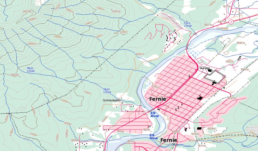
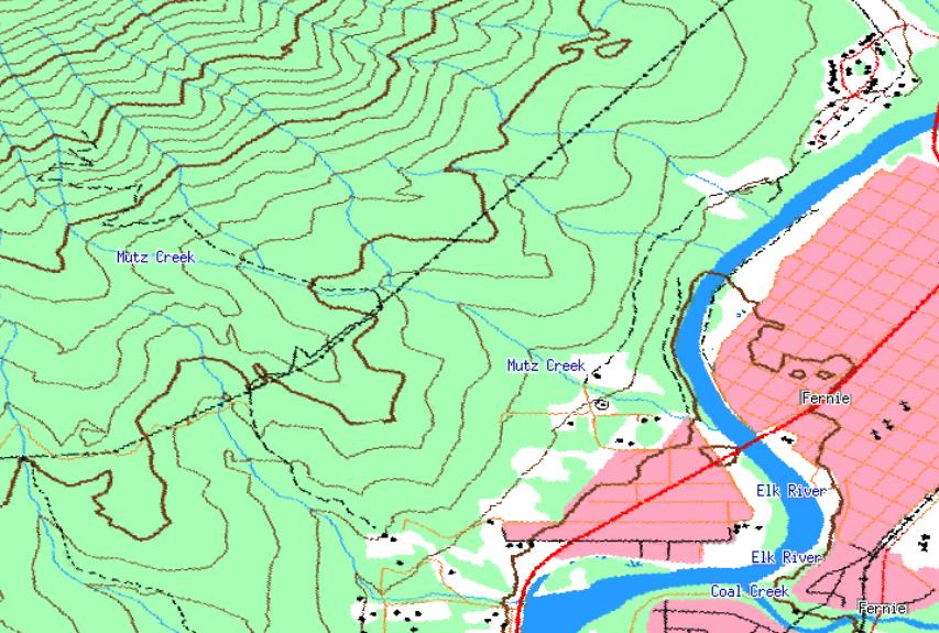
We're happy to announce the release of version 3.74 of TopoFusion Pro.  Atop the feature list are new and improved Canadian Topo maps.  TopoFusion was one of the first mapping apps to include downloadable topographic maps for all of Canada, and now we've gone a step further with these new maps, available courtesy of WMS-Toporama on GeoGratis (official public announcement of this new server hasn't even been made yet).

Example image:


click to enlarge


Here's what the old ones looked like:


click to enlarge


Quite a difference in clarity and added info.  Perhaps the best addition is that of elevation labels on the contours (which were absent on the old maps).  Check them out by downloading the latest TopoFusion Pro, or for registered users, check your purchase email for download instructions. For other additions and fixes, see Revision History.

1269
TopoFusion Pro / More maps than you can shake a stick at...
« on: March 27, 2009, 10:41:13 AM »

I just checked the size of my 'master' map cache.  It's well over 20gig now:


I'm quite happy with the way TopoFusion handles this large of a map cache.  On my machine map display is still very fast.  For all my usual 'haunts' I never have to download maps anymore.

When we designed the caching system back in ~2002, we went for maximum efficiency (while still maintaining minimal disk size), but we didn't really think we'd be operating on 20+ gigs of maps at a time.   8)

Anybody have a larger map cache than that?


1270
TopoFusion Anouncements / 3D downloads back
« on: March 27, 2009, 09:03:34 AM »
3D downloads are back and fully functional!!

1271
Beta Testing / v3.74 beta
« on: March 26, 2009, 02:17:01 PM »
Hey folks,

One more beta before we get this one out the door and turn attention to bigger feature additions.  Here's the list:

3.74 - [3/26/09]

Added shortcut key ('E') to remove last point drawn in draw track mode
   (allows rapid point removal)
Fixed bugs in the split track feature causing non-fatal crashes
Fixed mouse cursor issues when selecting a start point for multi playback
Added hidden feature to invalidate old Canadian topos (contact us for details)


A user came up with the shortcut key for 'remove segment' on drawing and it's brilliant -- can't believe I didn't think of adding something like that earlier (before you had to right click and choose the menu option, which was a pain if you followed the wrong trail/road for multiple points -- happens to me all the time).

Otherwise some more fixes, and like it says, if you want to know how to invalidate your old canadian topos to make room for the new ones, send us an email.  It's very easy, but just a little hidden in the software.

Thanks.

1272
Beta Testing / Re: v3.65 to v3.68 - new PhotoFusion stuff
« on: March 26, 2009, 02:14:16 PM »
Thanks a lot for the consideration and ideas.  There's definitely more to come with PhotoFusion in the near future.

1273
Beta Testing / Re: v3.73 - Improved Canadian Topos!
« on: March 26, 2009, 02:12:33 PM »
Larry,

Download 3.74 (just out now) and contact me by email for instructions on how to kill your current canadian topos while still keeping all your other maps.

It's in the software but in the 'debug' menu since I don't think many will need/want it.  I'll let you know how to get to the debug menu if you're interested.

Thanks.

1274
TopoFusion Anouncements / Re: 3D downloads not working
« on: March 26, 2009, 11:35:03 AM »
Bump.  Still not working.

1275
TopoFusion Anouncements / Re: Version 3.60 - Color Aerials
« on: March 26, 2009, 11:32:04 AM »
Didn't make it until the next release (out soon), but definitely the next one.  Sorry for the delay.

1276
TopoFusion Anouncements / 3D downloads not working
« on: March 26, 2009, 09:53:23 AM »
Looks like the Nasa server is not sending 3D (elevation) data right now, so auto-download 3D mode will not work, and likewise with "add elevation to track" in Climbing Analysis.

Our friend at the server is creating a tiled elevation dataset for us (so that TF can cache, tile and add more elevation features), so I'm guessing that's what the downtime is for, but I will check.

I'll update this thread when I know more.  Thanks for the patience.

1277
TopoFusion Pro / Re: Pre Downloading Maps
« on: March 22, 2009, 02:39:16 PM »
Sorry I missed replying on this one.  Fell through the cracks somehow.

There's a toggle on the toolbar that turns off map downloading.  You can then zoom/pan around to see what you have and don't have.

BTW -- the next version of TF (should be released this week) features highly improved Canadian Topo maps.  You may want to wait for that.  See the beta forum for examples and details.

Yes, the software looks at how many of the tiles requested in a batch are already downloaded, and computes the number 'to go' based on that.

Thanks.

1278
TopoFusion Pro / Re: Can TopoFusion Maps be uploaded to a Garmin 705?
« on: March 21, 2009, 10:34:42 AM »
I believe you can do this.  Instead of using any piece of software (TF or Training Center) to upload a .GPX file, you can drop it into the "current" GPX directory and then can find it on the unit and do "Display on Map."  I don't have a 705 with me right now or I'd give you better instructions.  I've seen it done in the past.

Maybe a 705 expert out there can chime in?

1279
TopoFusion Pro / Re: Can TopoFusion Maps be uploaded to a Garmin 705?
« on: March 21, 2009, 08:44:42 AM »
It depends on what you mean.  The background maps, which are images, can't be transfered to the 705.  The 705 (and most other Garmin GPS units) are designed to display vector maps, not images.

There are a few tricks that people have pulled (like a util called MOAGU), but in my experience the process is long and the results not very usable.

You can upload a track (or a course) and have it available on the Edge to show and follow.  This you can do with TopoFusion itself.

Does that answer your question?

1280
TopoFusion Pro / Re: custom combo maps
« on: March 20, 2009, 12:46:38 PM »
Looks like it's correct, but maybe missing a few things like the Tiger shortcut.

The 'O' key goes to combo no matter which tilesets are used for it -- same goes with the 'a' toggle.

You can also see the shortcuts in the program itself, under the 'Map' menu.

1281
TopoFusion Pro / Re: Save as Gpx or Tcx?
« on: March 19, 2009, 06:10:05 PM »
Good question.

I'd do whichever TopoFusion gives you as the default.  If the track you are saving has heart rate, cadence or power data with it, TopoFusion will default to .TCX.  Otherwise, GPX is the best choice.

GPX does now support HR and CAD, but I'd still recommend TCX if you want to save that data.  Not many programs read HR and CAD in GPX (TopoFusion is one of few that do).

So basically GPX is the best unless you have that extra data, and TF will default to that depending on what you're saving.

1282
TopoFusion Pro / Re: Live tracking; removing black track line
« on: March 19, 2009, 06:08:10 PM »
Oh, the black line stays after you save the track?  I suppose it should do a clear afterwards, since the saved track will be displayed.  Unless... I suppose someone may save portions of their track out and still want the whole thing there.

There's a "Clear Track" button on the Live Tracking dialog that should do what you're looking for.

1283
TopoFusion Pro / Re: custom combo maps
« on: March 19, 2009, 06:05:41 PM »
Hey Larry,

You can change which maps go into combo, yes.  Color and Landsat aren't supported, but TIGER and urban are.  So you can do both at the same time.

Also, there are hotkeys for both -- 'U' for urban and 'I' for tiger.  ('T' of course is for topo).

Does that answer you question(s)?

1284
Beta Testing / Re: v3.73 - Improved Canadian Topos!
« on: March 13, 2009, 09:03:54 AM »
Just to check, you're OK with the wasted space that the 'dead' tiles will leave?

Even if I don't do a new tileset number I could add a hidden feature to invalidate all current CAN topo's, which would accomplish the same thing.

Or maybe a new tileset ID is just easier.  I'll see if I can just do that.

1285
Beta Testing / Re: v3.73 - Improved Canadian Topos!
« on: March 11, 2009, 04:13:02 PM »
No worries.  I'd rather hear about false alarms than nothing at all.

Still seems strange that installing over might cause something like that.  You're on Vista right?

1286
TopoFusion Pro / Re: Export View and Generate HTML
« on: March 11, 2009, 04:01:30 PM »
Bob--

There are good reasons for all the of the tilesets being available, but you are right that many are redundant.  By default on a new install Topos 8m and 32m are disabled, for example.  In certain areas of the country it's useful to disable 4m but enable 8m, though.  I suppose a page on each tileset (esp. topos from terraserver) would be useful to folks.  I make a note to create one.

Setting the "Tileset zooming" is a little fuzzy, yep.  The best way to set it is to just experiment.  It applies to all tilesets and you are right that one might want different settings per tileset.  I think that's taking something that's already a little complicated and making it more so, though.

Thanks for the other suggestions.  Will change the PF error message.

1287
GPS, Trails, Training / Re: Running Threshold Power Test
« on: March 11, 2009, 03:56:46 PM »
Hey,

Sorry, this one fell through the cracks somehow -- I just noticed it now.

Here's Dr. Phil's explanation:

You then need to enter the details of your test effort. It should be 10k or greater, but should take one hour or less. It should also be run as hard as you can while still maintaining pace. Don't go out too hard and then end up walking or jogging.

Read more at:

http://topofusion.com/govss.php

Hope that helps.

1288
Beta Testing / Re: v3.73 - Improved Canadian Topos!
« on: March 11, 2009, 03:54:41 PM »
Gah!  Very strange.

I've seen (very rarely) an issue where the magnifying glass shows up when it's not supposed to.  So far restarting has always set it back to normal.

The right click thing sounds bad and could be related to recent changes.  What map mode were you in, and could you maybe send me the GPX file with the waypoints in it?

Thanks a lot for the report.

1289
Beta Testing / v3.73 - Improved Canadian Topos!
« on: March 11, 2009, 01:37:44 PM »
We just put out a new beta version that features upgraded Topo maps for all of Canada.

Here's an example.  Old version:


And in the latest version of TF:


Major improvement in clarity, detail and the oft-requested elevation labels on contours!  Awesome!

I have considered making the Canadian topos be a new tileset number, so that those with old topos could start anew.  Any opinions on this?  I think it's pretty clear these maps are superior (let me know if you think otherwise).

The other option is to simply start a new map collection (do this by deleting mapindex.dat and all mapsX.dat files).  This way you wouldn't waste the disk space -- changing the tileset wouldn't overwrite the old topo tiles -- they'd just be dead space on your HD.

I'm leaning towards just suggesting people start over if they want to get rid of their old maps.  You can also operate with both maps together.

By the way, you can 'try' the new maps easily by simply changing the "Directory for Maps" setting in Options->Preferences->General.  If you change that to a new directory you'll start over with no maps downloaded, then you can get fresh CAN topos.  Feel free to ask me questions if this isn't clear.

Complete list of changes:

3.73 – [3/11/09]  (Beta)

Added improved Canadian Topo maps
   Maps are more clear, detailed and up-to-date
   Including elevation labels on contour lines!
Fixed bug editing waypoints from the “File Properties” list of waypoints
Fixed erratic map scrolling at high zoom levels (floating point handling)
(Also affected some clipping errors at high zoom levels and other small           issues)
Changed maximum number of spline interpolation points from 20 to 30 (for
   Video syncing interpolation)

1290
Beta Testing / Re: Some fixes - v3.72
« on: March 11, 2009, 01:21:43 PM »
Thanks guys.  This one was a bit of a stumper, but I finally figured out what introduced it and got it fixed.

There's a new beta, 3.73 out right now with the fix.

1291
TopoFusion Pro / Re: Export View and Generate HTML
« on: March 10, 2009, 08:27:15 AM »
Yeah, not sure if I should disable that message or not.  It's still useful if someone is trying to do an export with images.

As for the red areas disappearing, is it just changing from topo 4m to (looks like) topo 8m or 16m?  That's very strange since the PF export should just be exactly 'what you see is what you get.'  The tileset should not change.

Try zooming in a bit (perhaps making your TF window bigger too) to get the better map back.  You could also change the 'tileset zoom' in Options->Preferences->Tilesets.  Set it to shrink smaller tiles.

Hope that helps.

1292
Feature Requests / Re: Time in Zones?
« on: March 07, 2009, 07:56:42 AM »
Nope, you're not missing anything.  It's on the 'todo' list, sorry.  Hoping to have my MTB equipped with both a PowerTap and a rear brake (I have the former, but can't run it with the latter) soon.  I think I'll be motivated to get rolling on more training features then...

Thanks for the inquiry.

1293
TopoFusion Pro / Re: Note to Edge 205/305 users (Forerunner too)
« on: March 04, 2009, 04:03:52 PM »
I sent a reply by email, but here it is for reference:

TF will be able to open it and you'll see all your runs.  You can profile each of them individually to some extent, but some of the features of the program assume that each run is in a separate file.  Like some of the statistics and mile split stuff.

I believe there are some free tools out there for splitting history files, but I haven't look recently.

1294
TopoFusion Basic / Re: Downloading to Garmin Edge 305
« on: March 03, 2009, 01:24:59 PM »
Oh, OK.  You probably need to convert the GPX file to a "course" inside training center.  I've done it before, but it's been a while.

Honestly, it's a lot easier to do this in TopoFusion.  Download the Pro demo version, install and follow the instructions I sent you.  You should get it as a course with very little trouble.

1295
TopoFusion Basic / Re: Downloading to Garmin Edge 305
« on: March 03, 2009, 12:46:04 PM »
Got your email and sent a reply.

Which version of Topofusion are you using?  Pro or Basic, and what version number?

1296
TopoFusion Basic / Re: Downloading to Garmin Edge 305
« on: March 03, 2009, 12:36:13 PM »

You are trying to upload a GPS file to your Edge 305?  Just want to check because in TF the terminology is that you upload to your GPS and download *from* it. 

This matters because you need to select the right option in the GPS dialog.  "Upload track", and "to saved tracks / courses."

There shouldn't be any difference uploading a tcx or gpx file in TopoFusion.  What error are you getting?

1297
Beta Testing / Re: Some fixes - v3.72
« on: March 02, 2009, 09:04:57 PM »
Hmm.  Where abouts in the world are you?  Not far north (AK or CAN?) are you?  Also, which tileset?

1298
TopoFusion Pro / Re: Garmin eTrex Database Error
« on: February 26, 2009, 07:03:56 PM »
Actually it should be easier to use saved tracks.  They show up by default on the map, ready to follow.  So there's no need to select and activate them.

Not sure why the upload as route isn't working on the Vista.  I'll get it fixed for the next version.

1299
GPS, Trails, Training / Re: Free Topo Basemaps - 40' contours!
« on: February 26, 2009, 07:01:45 PM »
Just wanted to note that they fixed the road issue for Pima county.  There's getting to be quite a collection of free basemaps.

The following states are also available from the miscjunk link above:

Hawaii
Idaho
Mississippi
New Mexico

1300
TopoFusion Pro / Re: Garmin eTrex Database Error
« on: February 26, 2009, 02:05:15 PM »
I get the same thing on my Vista - database error.

I'll keep looking, but in the meantime have you considered just using a saved track?  I rarely use a route to follow trails since the detail is lower and the beeping and such doesn't really help.

BTW, it shows 196 points because there are 100 track points (as you simplified to) and 96 waypoints.


Pages: 1 ... 24 25 [26] 27 28 ... 32