
Tucson Mountain Park Project -- Project Data Released
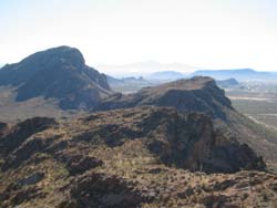
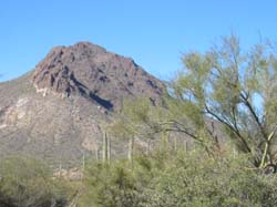
Tucson Mountain Park (TMP) consists of 20,00 acres of beautiful sonoran desert. Due to its proximity to Tucson, it is subject to a fair amount of use by hikers, runners, mountain cyclists and equestrians.
The Tucson Mountain Park GPS data collection project has concluded, and we have released the dataset collected as a part of this project.
Statistics:

112 GPX tracks from approximately 35 contributors
Highest number of submissions by one contributor = 15
84,000 total GPS points
9.91 miles average length of trip
1:30 average trip length (moving time)
1,250 feet average elevation gain


The majority of the tracks are mountain bike trips, with a smaller percentage representing hikes.

The data was used for development and testing of the K-history simulation model, as described in:

Scott Morris, Randy Gimblett and Kobus Barnard, "Probabilistic Travel Modeling using GPS Data,"
International Congress on Simulation and Modeling, Melbourne, Australia, Dec 2005.

PDF version available here:
http://kobus.ca/research/publications/MorrisMODSIM05-rev.pdf
Any questions about the dataset should be directed to:

smorris@topofusion.com

I would like to thank everyone who contributed to this project.

Scott Morris
topofusion.com
University of Arizona
Below is information about the project, no longer current:
Note: we are no longer accepting data submissions for this project. Thanks for your interest.
In order to accurately simulate trail users in TMP we need data (statistics) on how the park is used. Typically this kind of data is collected by paper surveys, on trail interviews or by hand (physically counting users). We propose to instead focus on automatic methods of trail data acquisition using GPS tracks. As GPS device use among recreators increases it will be possible to utilize this data in order to more effectively manage our public lands. For more information about using GPS data, see Using GPS for trail simulation.
 For TMP, we are collecting GPS data to obtain:
- 1 - a complete trail map of the area
- 2 - average travel speeds for each trail
- 3 - usage statistics for each trail.
Information for Volunteers, including FAQ
Data Submissions
Note: we are no longer accepting data submissions for this project. Thanks for your interest.
We are collecting GPS tracks of trips taken at TMP. Tracks are "bread crumb" trails produced by carrying a GPS device around and setting it to record your journey.
In the initial stages, we are looking for any and all GPS data, regardless of the format or device used. However, we would prefer to receive data in the GPX format. GPX is an open standard GPS data exchange format that is read and written by many programs. The key advantage of GPX, in our view, is that it stores both elevation and time data for each track point. The time component is essential for extracting travel speeds on trails for use in the simulation.
We have offered the free demo version of TopoFusion to encourage people interested in collecting data to use the GPX format. The free version interfaces with both Garmin and Magellan GPS devices. Collectors of data may use TopoFusion to download and save their tracks in GPX format.
See the Download page to obtain the TopoFusion Demo. The demo also includes our first run simulation of TMP (mountain bikers only). If you'd like to run the demo on data collected solely by the authors, see Starr Pass Demo.
 Several project participants collected enough data to receive free copies of
TopoFusion GPS mapping software.
Text of Call for GPS Data
Several project participants collected enough data to receive free copies of
TopoFusion GPS mapping software.
Text of Call for GPS DataFor questions about the project or to submit data, email:
starrproject@topofusion.com
Thanks for your interest!
Back to Simulation home for more information about the project.