
v5.30 – Mapquest restored, Tracks dialog, smoothing
July 17th, 2016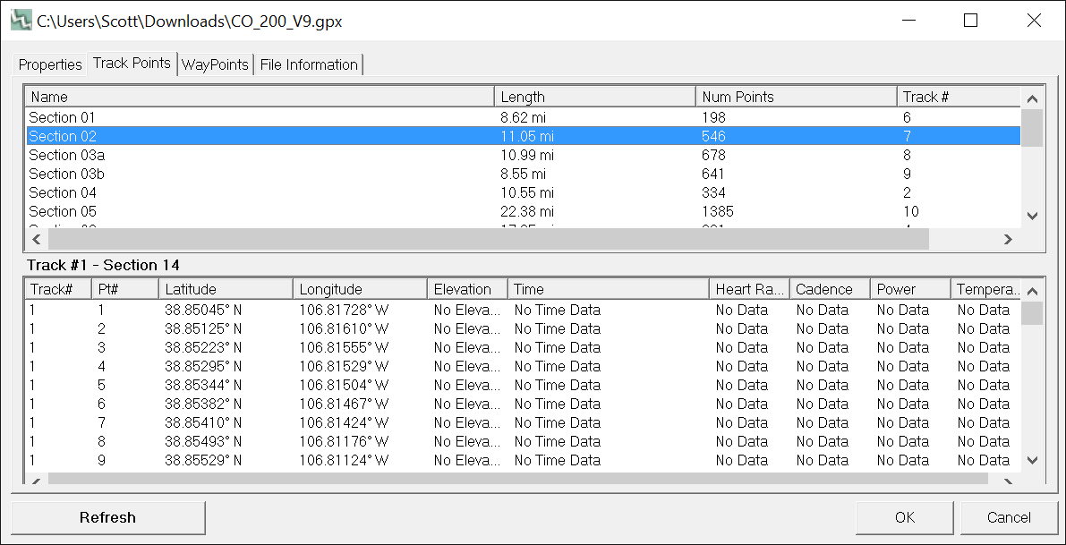
We’ve released version 5.30 of the software, featuring a number of enhancements to both the Pro and Basic version. A few days ago Mapquest started requiring an API for use of their mapping services. Previous versions of the software started showing an error tile. This update restores access to the Open Aerial and Mapquest OSM layers.
The ‘file properties’ dialog has seen a revamp, such that individual tracks within a file are now listed, and can be deleted, highlighted and drilled down into. (See dialog above). This has been a weakness of the software before. It should be easier to work with files containing multiple tracks now.
Some improvements to the elevation functions have been added. There’s a ‘smooth elevation’ function in Climbing Analysis and File Properties. This is useful for noisy data, processing with a box filter of width 5.
Speaking of box filters, the default climbing algorithm used in TF now employs a filter. This is something that is long overdue for being dealt with. Now that most people collect data at 1 point per second (or greater!) the possibility for error in computing climbing numbers has risen since the humble release of the software some 14 years ago. We changed to include some basic filtering by default, to bring our numbers more in line with popular ‘apps’ like Strava and Garmin Connect. Climbing Analysis is still there and has received a bit of an update, as well. It’s still a great place to look at different ways of computing that all important number — how much vert did I log?
Lots of other small fixes — we definitely recommend updating!
Update your TF and check out the new version (full list of changes below), or if you are new to TopoFusion, go ahead and try the demo. And as always, let us know what you think, especially if you have a suggestion for a new feature or different way the software should work.
Thanks!
Team TopoFusion

Head over to the Download Page to try TopoFusion out, free of charge.
Registered users refer to your registration email for the download link, or go here to request your code and the download URL.
Full list of changes
For a complete list of changes see the Revision History, or keep reading here for what has changed since the last public release:
5.30 – 7/17/2016
Restored access to Mapquest’s Open Aerial and Street tilesets
5.26 – 7/2/2016
Fixed additional issues with waypoints coming up in right click when not near
Fixed zero length segments (tracks within a file) in new Tracks area of File
Properties
5.25 – 5/27/2016
Added a Tracks area in File Properties, giving a list of tracks within the file
Double click to zoom map to a track. Right click to fill the table with
points and for other options (delete, edit track properties).
Added Smooth Elevation data (filter) button to Climbing Analysis (and File
Properties dialog). Button applies a box filter of width 5 to the data for
each press.
Changed global elevation gain algorithm to include a box filter of width 5.
This affects the profile tool and elevation gain stats in active file list.
The change was made to help give more realistic climbing numbers.
Added shortcut key for opening/closing the active file list – Spacebar
Fixed issue with cursor changing to magnifying glass with certain files loaded
Fixed issue with waypoints always coming up in right click with certain files
Improved response of Climbing Analysis when missing DEM tiles or with
downloading disabled
Changed “Training Center” preset to “Strava/Garmin Connect”
Fixed individual point NO_TIME loading .KML files without time
When saving, filled
one track