TopoFusion.com

Archive for August, 2008

Version 3.41 released – Australian Topos and line styles!

Wednesday, August 20th, 2008

We’re pleased to announce the release of a new version of TopoFusion.

The biggest addition to this version is access to topographic maps for all of Australia, courtesy of the excellent MapConnect server:


For more details on these maps see available imagery. We’re excited about this addition since it has been a long requested feature, and we have a few potential projects in OZ as well. Find the Australian maps paired with the Canadian Topo tileset — there’s no overlap so they share the same tileset.

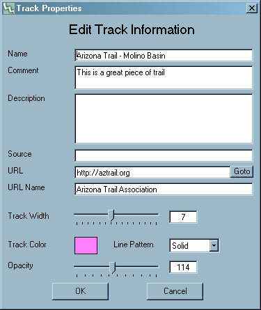
The other major addition is “GPX styles.” This allows users to set and display attributes such as width, color, opacity and patterns to GPS tracks and drawn lines. This is a great improvement for map making, and is especially useful for Trail Networks.


To change these settings, right click on a track in the map window and choose “Track Properties”. The dialog looks like this:


These attributes are saved in the “GPX styles” schema, an extension to the GPX format that is supported by several other mapping programs.

Full list of changes since v3.39:

3.41 – [08/15/08]

Cut tracks now inherit the original track’s color/width/pattern/etc
Fixed File Properties to only apply color to all tracks when color is
actually changed
Fixed bug when merging tracks while download box or drawn track is active

3.40 – [08/12/08]

Added Australian Topo Map server!
Covers all of Australia
Shares tileset with Canadian topo – “Can Topo” now “Can/Aus” tileset.
Can/Aus downloads Canada Topo in northern Hemisphere, Aus Topo in southern
Added support for GPX_style extension (also KML Styles)
Added per track line width
Added per track coloring
Added per track opacity
Added per track pattern (dash/dot, et cetera)
Added track names to KML exports
GPX files now saved as GPX 1.1
Drag and Drop of files now supported for main map window
(previously only active file list could be dropped into)
Fixed synchronization issues between profile/simplify/waypoint/track dialogs
Fixed infinite loop with large GIS waypoint files, skipping at high zoom levels
Fixed false clipping for long track segments
Fixed problem reloading tiles when clicked outside current UTM zone

Dances with Dirt Ultra – special race version of TF

Monday, August 18th, 2008


Dances with Dirt is a 50k / 50 mile ultra running event based
out of “Hell, Michigan.” It’s September 6th, 2008. Here’s a description of the course:

The footing (What footing?) is rocky, muddy (a few river crossings) and
loose in places. The trail is not maintained (non-existent) in some areas. We
love this stuff and hope you do too. ILK RULES! Bring on the ILK! ILK me! Is
the trail as tough as advertised? Yes and No. I’t s no run down a nature trail
(but at times it is just that), you will get wet and muddy. You won’t get swept
down stream in any whitewater. Some big hills but no supplemental oxygen is
needed. Our descriptions are a disclaimer. All in all, a great run in a
beautiful environment…with stupid spots.

Sounds like a great time! Race organizers used TopoFusion to map and
tweak the course. And in a special promotion, we’ve offered a “Dances with
Dirt” version of TopoFusion. This free version of TopoFusion doesn’t have any
Demo tiles obscuring maps, nor is it limited to three files open. It is,
however, limited to viewing the area (southern MI and northern IN/OH). This
version also includes all the GPS files for the Dances with Dirt course.

To download the Dances with Dirt version of TopoFusion, and for some instructions head
over to:

Dances with Dirt TopoFusion demo page.

400 miles of Oregon Singletrack Bliss

Saturday, August 9th, 2008


The folks behind TopoFusion took a break from code monkeying (and from the Arizona heat) to tour the Cascades of Oregon.

We’re self supported bikepacking fanatics, and this trip was one of the best yet. 400 miles of singletrack, including the three legendary river trails: North Umpqua, Mackenzie and the Middle Fork of the Willamette. Oregon has some wonderful trails, and they we very well suited to bikepacking!

It was a long trip, so the journal is quite long. But it’s chock full of some amazing photos.

In three chapters, read along as we eat candy bars for dinner, get swarmed by mosquitoes so thick they blocked the sun, break our most valuable repair tool (5mm allen wrench) and, of course, enjoy many an endless mile of sinuous, beautiful trail.

Oregon Singletrack Tour Chapter 1

Oregon Singletrack Tour Chapter 2


Oregon Singletrack Tour Chapter 3

Racing the Colorado Trail with TopoFusion

Friday, August 1st, 2008

The second annual Colorado Trail Race is underway right now. 23 mountain bikers lined up to race 530 miles of singletrack from Denver to Durango. This race is epic with a capital E!

Some of the racers are carrying SPOT tracking units, and there’s a leaderboard showing current positions. But the leaderboard is pretty static — we at TopoFusion knew we could do more.

Using TopoFusion’s newly updated and revamped Multi-track playback feature, it’s possible to replay the race so far and watch it unfold, overlayed on any of the host of imagery supported by TopoFusion.

Check out the replay of the first four days of the race, hosted on vimeo:


Colorado Trail Race Replay, Days 1 – 4 from Scott Morris on Vimeo.

Here’s just the third and fourth days, this time overlayed on a topo map:


CTR Days 3-4 from Scott Morris on Vimeo.