Version 3.23 was released today.Major changes:
* Due to a change in the server, version 3.20 can no longer download Canadian Topos. The latest release fixes this.
* Extensive support for Edge/Forerunner units:
- downloading HR/Cadence data
- profiling HR/Cadence
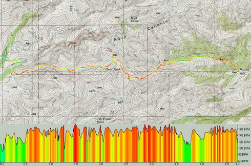
- track shading by HR/Cadence
- save/load files in .TCX/.CRS
- upload tracks as "Courses"
Example of Heart Rate shading with corresponding HR profile:

* More FUSION in your TopoFusion. You can now choose the tilesets you wish to combine in combo mode. Examples include tiger/aerial, urban/aerial, urban/topo, etc. Look for the tileset dropdowns in the Image Processing dialog.
Example combo
Urban/Tiger tilesets:

* Smart merging of tracks - less use of the "reverse last segment" feature.
* The profiler in general got a makeover and is now more useful.
* Check out the "moving intervals" analysis in the Lap Analysis menu. I've been having fun placing waypoints labeled with the amount of time spent stopped on my GPS tracks. The results are sometimes quite surprising!
* many smaller additions, tweaks and general improvements.
From the revision list:
3.23 - [2/20/08] (Full Release)
Fixed error connecting to Canadian Topo Server
Added Heart Rate/Cadence downloading for Edge/Forerunner units
Added Garmin .CRS/.TCX import (necessary to store HR/Cadence data)
Added ability to upload tracks as "Courses" to Edge/Forerunner units
Added new track shading options: Heart Rate, Cadence and Power
- faster access to shading type in the "Map->Track Shading" menu
Added new statistics and "y-axis" options to profile window
- including moving time, HR, Cadence, Power
- Climbing/Descending stats now match main TF window
Added "Moving intervals" analysis type to Lap Analysis dialog
- Use to place waypoints at each "stop" on a GPS track
Added "Export to Raceday" button to Run Analysis - exports running power
data to Physfarm's Raceday software
Added "Place Waypoint" button to Goto Coordinate dialog
Forced waypoint dialog to stay open after invalid coordinate entry
Fixed bug with zero elevation in NMEA live tracking
Fixed bug when exporting 3D screenshots with "add profile" checked
Improved clipping/drawing speed for photo icons
Added warning message when uploading tracks that are too large
Fixed GPS dialog to keep file choice when choosing between options
Fixed problem with highlighted track point from file props not showing up
Fixed bug causing waypoints to disappear after editing
Fixed some minor profile details - stats, low heart rates, crosshair tracking
Fixed bogus name field in CRS/TCX files
3.21 - [1/28/08] (Beta)
Added ability to change tilesets used in combo mode
(eg: TIGER/Aerial, Urban/Topo, Urban/Aerial now possible)
Added "smart" merging (track merge tool)
- also: holding shift is no longer required to merge
Added export of Garmin Course files (.CRS)
Forced onscreen message OFF when exporting
Added "open containing folder" button to export view dialog
Added true north azimuth output to track drawing tool
Added settings for UTM grid line width and opacity
Added setting for waypoint symbol size
Fixed problem with stray point added to end of drawn track
Improved interplay between other graphic intensive software (e.g. GE)
Fixed issues with D3D_OUT_OF_MEMORY errors