Alrighty, there's a new beta out, by the version 4.05, featuring colored elevation tiles. These are generated, on-the-fly, with quite a bit of control by the user. Find the settings in Options->Shaded Relief/Elevation Tiles.
The shortcut key is "E", and the tileset is called "Elevation."
You can control the color spread, similar to the track shading colors already available. The min/max elevation is also customizable, with a very handy button to grab the current min/max for the scene. The "Contour" checkbox forces sharp boundaries between the colors, instead of the default shading between them.
The maps are not stored in the cache and are generated as needed.
You can get some pretty cool effects, especially when combined with shaded relief and using the new combo mode to blend with other map types. A few examples:
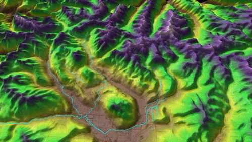
3D mode, classic TF colors:
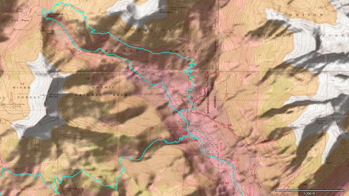
Using the contoured option for sharp boundaries, and blending with myTopo maps:
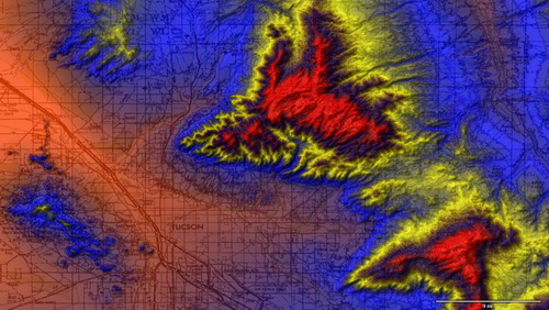
Again blending with topo maps, but funky fractal colors:
Play around with it and let me know if you notice any issues or have any questions! Thanks.
Full Changes:4.05 – [9/22/10] (Beta)
Added new “Elevation†tileset – colored elevation tiles
* Find options in Options->Shaded Relief/Elevation Tiles
* Shortcut key is “Eâ€
* Tiles are generated, not downloaded or stored
* Color shaded by elevation, with ability to control max/min and colors
* Checkbox for “contoured†(sharp boundary between colors)
* Coverage is near worldwide (all but extreme latitudes)
* Use Combo with other map types for some nice effects
Shaded Relief options moved from Combo Blending dialog into new
Dialog shared with Elevation Tileset options
* Also added button to turn Shaded Relief on in dialog
* Fixed “darkness†setting not being saved correctly
Logbook – “add non-gps entry†now defaults to date selected in calendar
(instead of today’s date)
Added ability to read “ns3†power data from TCX files, (Garmin Connect)
Fixed refreshing of map when downloading new maps in Combo mode
4.01 – [8/12/10] (Beta)
Fixed 3D display problems in Combo mode
Fixed large scale exports in Combo mode
Changed all “save as…†dialogs to remember last directory saved to
This includes the GPS download dialog
Image Blending / Shaded Relief dialog now Combo Blending / Shaded Relief
Minor cosmetic changes to dialog
Added and fixed new Combo Blending presets
Fixed problem loading GPX files with trailing spaces in XML tabs (bt747 utility)
Fixed crash when removing too many segments (hitting the ‘E’ key) too many times
In either the Draw Track tool or the Merge tool
Fixed problem renaming files when changing only the case of letters in filename
Fixed invalid assumption reading .kml files with placemarks (waypoints)
Installer now gives better message when trying to upgrade with TopoFusion open
