Lee and I went searching for a mountain bike route through the Superstition Mountains. We still haven’t found one.
We rolled through the streets of Superior at noon, heading west to the Arizona trailhead. After crossing the railroad tracks the singletrack sweetness began. The trail follows a ridgeline that was erupting with spring grasses and wildflowers. Occasional rocky sections saw us walking as we made progress towards through the foothills.
The trail in Whitford canyon seemed washed out by the major winter rains, but the canyon itself was spectacular: red cliffs, fat saguaros and a crystal clear creek. This would not be the last creek we’d deal with on this trip.
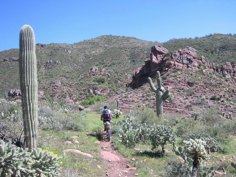
Singletrack in Whitford Canyon
After emerging from Whitford we rode a nice contouring singletrack section. It was faint and rarely used, but a delight to ride. It ended all too soon, dumping us out on dirt road where we would divert from the actual AZ. The Superstition wilderness waited at the top of Montana Mountain. Our plan was to head east around it.
Our road, FR 342 wasted no time fooling around. We were soon reeling in granny gear, struggling to climb steep but thankfully not ridiculously rocky pitches. Funny how hard efforts and lack of wind can send your core temperature skyrocketing. I felt like I was baking in an oven any time we lost our slight headwind.
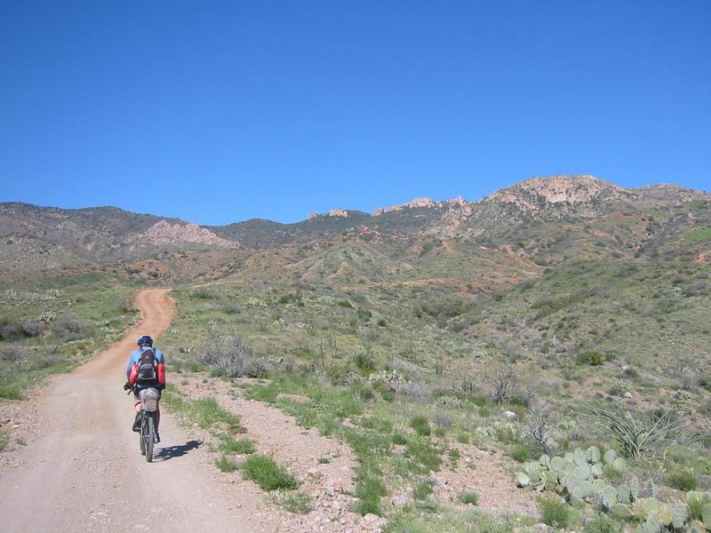
Climbing into the Superstitions
1800 feet of climbing later we crested the pass and looked down into Haunted Canyon. There was some semblance of a trail at the top, but it did not look good. The route I drew from aerial photographs showed us dropping in slightly further east. Around one more turn an actual 4×4 road dropped into the bottom of the canyon. I got behind my seat and held on for the steep, rutted plunge.
The road died at the first crossing of the stream. The fact that the stream was running so high (we were perhaps 500 feet from the start of the drainage) was not a good sign. Our route followed Haunted Canyon to its junction with Pinto Creek some 8 miles lower. It could pick up some serious flow in that distance.
Eventually we spotted an old trail that climbed out of the canyon. This didn’t seem right, but following it led to a rideable but extremely overgrown descent back to the canyon. We were making progress, if slow. As expected, the creek picked up strength as we made our way down the canyon. The crossings became shin, then knee deep. As the sun fell it became clear we weren’t going to make it out of Haunted today as we had hoped. The going was just too slow, creek crossings too numerous, and hike-a-bike too tiring.
We passed a perfect spot to sleep (Tony Ranch) complete with grassy meadows, an old cabin should it rain, and a certain tranquility to it. We opted to use the remaining twilight to proceed further down the canyon since the conditions were getting slower and slower. Near dark I made a bonehead move based on the assumption that since the past 25 stream crossings had no mossy rocks, the next one wouldn’t either.
With bike on shoulder I went into the creek, catching myself to avoid a complete submergence. I slammed my knee fairly hard. If it had hit a little higher that might have been the end of the ride, or hike as the case may be, for me.

Lee in Haunted Canyon
It was no longer safe to cross the stream at night, even with our LED lights. So we made due with what space was available (we slept directly on the old trail). We made a fire to dry some of our gear, then went to sleep wondering if we’d get a visit from the ghosts of Haunted Canyon.
The morning was cold, but we suited up to resume combat with the deep crossings of Haunted Canyon once again. The lower section of the trail had seen more recent use, but large portions of the trail were completely washed away. So we’d alternate between navigating log jams to cross the creek and tasty singletrack nuggets–the kind of trail adventure riders lust after.
At one point the trail began a steep hike-a-bike out of the canyon. We were not sure what was going on, but it soon became clear: an impressively tight gorge was ahead in the canyon and we were skirting it.
Lee spotted a cigarette butt. Minutes later we found the source of said butt. Two hunters (very nice guys, actually) were camping, with cigarettes. They said they had walked a bit up the trail to watch the sunrise. They weren’t far from the trailhead. We soon emerged from Haunted Canyon onto a forest road. This would be the fastest and easiest riding of the day–all 5 miles of it.
We approached the Horrel Ranch after crossing a very deep Pinto Creek.
“Hi there. We’re wondering how the road is down Pinto Creek.”
“On bike? Oh, you should be fine on a bike.”
“Really? It goes all the way through to Roosevelt Lake?”
“What? No, are you crazy? There’s no way to get to Roosevelt, unless you want to swim there!”
We decided to check it out anyway. After a mile of coasting on the road we hit Pinto Creek. Any trace of the road had been long washed away. The creek was raging deep. Trees were stacked on top of each other. There wasn’t even a clear area to walk.
It was one of those odd moments in a ride. At first it was clear that we needed to abort. “Well Scott, it looks like we’re screwed.” Neither of us wanted to turn around, but we also knew how arduous continuing could be.
We forded Pinto to take a look at the other side (and the 4×4 road leaving the canyon, which we knew was a dead end). There was a slight rocky opening that we could walk down, left by a channel from higher water flow. A consensus or forthright decision was never really made, but our minds were in agreement. We both started walking and before I knew it we were far enough down Pinto Creek that turning around was no longer an option.
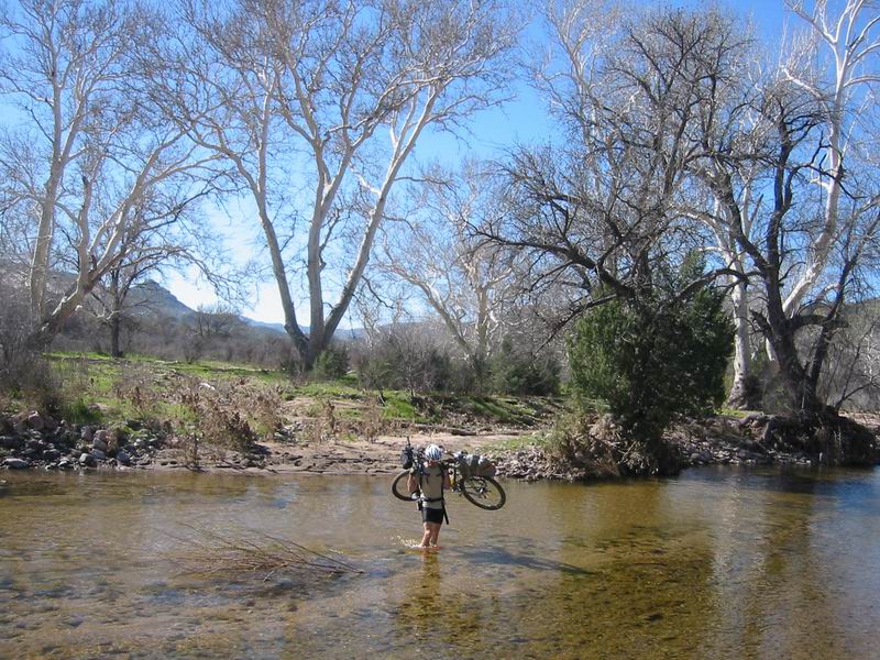
Pinto Creek at the end of the road
It was very tedious, especially given yesterday’s trek down Haunted Canyon. The best comparison I can give is with trying to navigate a disaster area. Disaster area is an accurate description. Debris from the flood were in trees taller than me. Log jams, piles of boulders, sheer drops on unstable dirt/sand, thigh deep water and cat claw became our reality. The loaded bike was a constant hindrance–getting stuck by branches, falling in the water, slamming cut and bruised shins.
When the situation is this bad you usually expect one of two things. 1) things will get worse. 2) things will get better. But for the next 5 hours nothing really changed. We found no sign of a road, no section that was rideable, no relief from the vegetation, but it also never got harder.
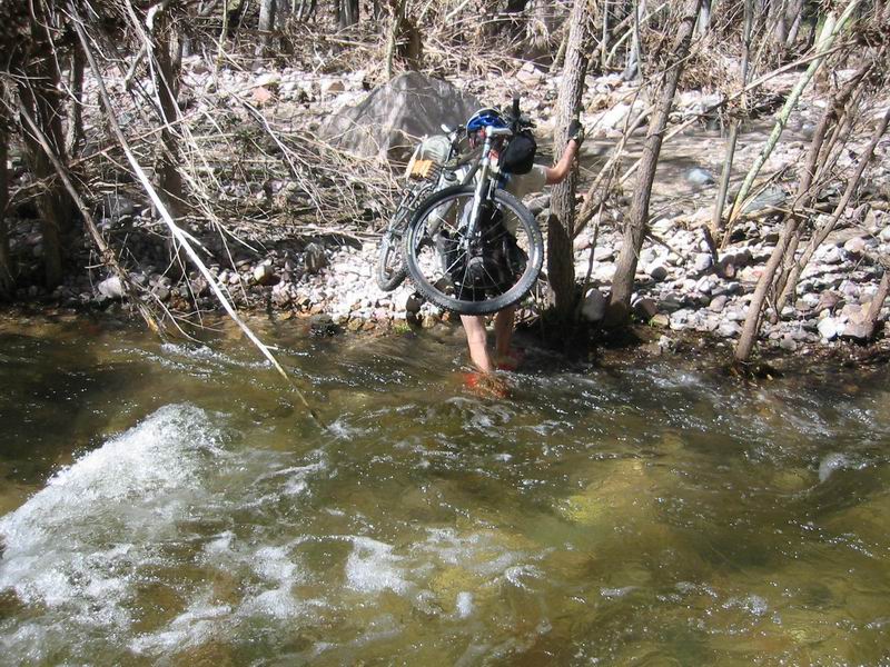
Lee crossing Pinto Creek for the 100th time
For a moment I lost my resolve. It was just too frustrating and progress was unbelievably slow. I had my GPS showing me the straight-line distance to the Bell Ranch, which we believed was to be the end of our suffering. After 15 minutes of hard effort, lowering myself down to cross the slippery creek and hoisting myself up the other side to fight through a thick stand of pointed trees, I’d look to see that we hadn’t even gone a tenth of a mile. I figured we were making less than 1 mile per hour and we had at least 3 to go.
I can’t say for sure what was going on in Lee’s head, but if he was struggling, he didn’t show it. He was leading the charge for most of the way down Pinto, though he did often remark at how tedious it was.
It was looking pretty grim. There was no desperate need to get out before dark since we had camping gear, but I knew we had to get out of there some time, so it may as well be now. It is of no benefit to complain, let negativity creep in or give up, so I placed my bike on my shoulder and jumped into the creek for the 100th crossing of the day.
But things were really not that bad. They were much worse than that. They were also better than that. We were outside. The sun was shining. We had plenty of food and were both in perfect health (except for the blisters developing on Lee’s feet). We were exploring a route that had intrigued us for months. We were actually having a good time, it was just beating the crap out of us.
‘Hour of thy suffering’ (as this route is now named) did come to an end at the Bell Ranch. My heart jumped at the sight of a solid graded road. We kept our sandals on for a few more deep crossings, then switched back to our shoes to climb away from Pinto Creek at last.
The cooling wind and fast speed of the road was a gift. After some climbing we emerged on in-progress highway 188. We blasted down 8 miles of fresh dirt that soon will be a major highway.
A sign indicated restaurant. Involuntary impulses turned our bikes off the road to the Roosevelt Lake Lodge. We stayed there that night, broken and sore. We were not sure what to do the next day.
We rolled easy pavement in the morning along Roosevelt Lake. With all the rain the lake is at record levels. It was a superb morning to be out riding. The air was still, the hills small, and slowly the horror of Pinto Creek began to fade from our memories. At one of the campgrounds we saw a touring couple on a tandem pull out. We ended up chatting with them for a couple dozen miles. They were from Canada and were training for a big tour in France this summer. It’s always interesting to see what kind of people you meet out cyclotouring.
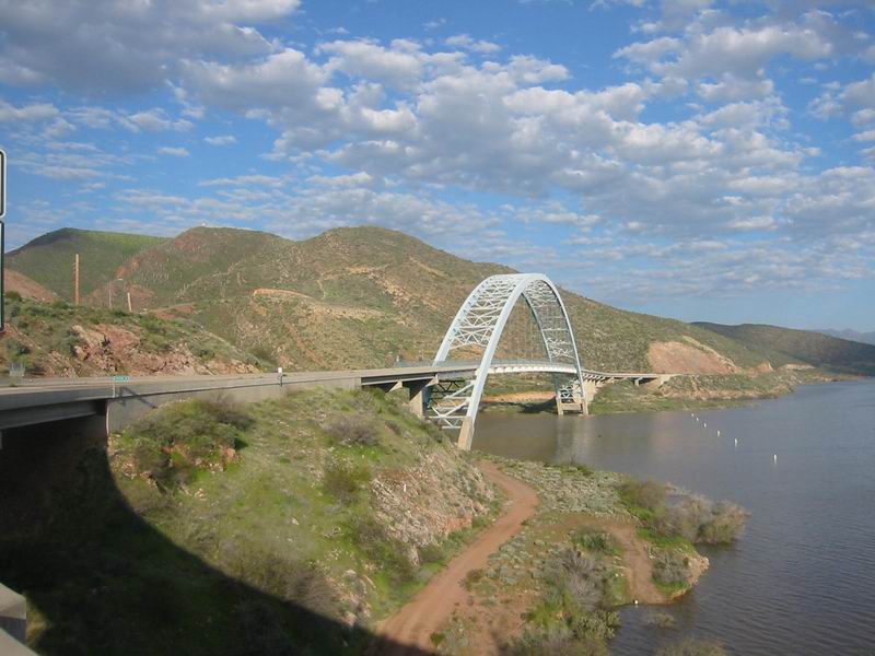
Bridge on Roosevelt Lake
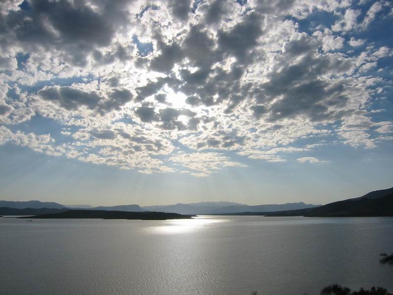
Morning clouds over Roosevelt
We stopped at the turn off for the El Oso road — our climb into the Mazatal Mountains. It looked very tempting, and, believe it or not, I was burning for a 4000 foot climb into the trees. But the descent off the other side held a very serious possibility of turning into a hike-a-bike down a running creek. With all that we had been through we were not willing to take that risk. So we continued on pavement to Jake’s Corner, where we took a great divide style dirt road over to the town of Rye.
After filling our tanks on tasty but slow food at the Rye cafe, we left town on FR 414 to climb into the foothills of the Mazatals. It was churned up from people driving it while muddy. It would be a complete mess when wet. The road crossed Rye Creek a few times, but we rode through most of them.
We transitioned into forests, signaling our approach to the Mogollon rim. Living in Tucson gives me a warped appreciation for riding in the forest. I just love it. The Willow Fire, however, had taken its toll on most of the area. I still just love even burned forests. They are just part of life in the western united states.
We climbed to the Mineral Creek trailhead to investigate a possible shortcut — Pole Hollow. It was logged out and rideable at first, but a untouched tree blocked our path, and below the trail was severely washed out. Painful traversing around the tree with loaded bike was all I needed to convince me to abort. It was clear that whoever had started to clear it had stopped here. So we hiked up to the ridge, back to FR 414 to resume forest riding.
It was a good choice as the riding was excellent and easy going. We cruised along a high ridge before beginning a descent to the East Verde River. When we crossed the creek in Pole Hollow I was even more happy about our decision — it had a good flow in it.
We forded the East Verde in sandals. It was well above my knees in two separate channels. On the other side a kid sat in his white SUV contemplating making the crossing. Lee advised him against it while I went to back across to get my bike (I took Lee’s across the first time since his blisters were killing him in his sandals). When I went back to the river to clean off my feet the kid was still thinking about it, seemingly determined to make it across. He asked me which way the road even goes. I had to point out where the best route would be.
We left him to consider the risks of showing off for his girlfriend. The next section of riding was some of the best we had seen. The sun was approaching the horizon, bringing with it still air, long shadows and quiet light. The road wound around on top of a ridge, technical and steep at times, and affording views to all sides. I felt like I could ride forever in these conditions.

Ridgetop rolling into the afternoon
The kid passed us at some point on the climb, exercising some measure of prudence. After three hours of riding away from the river Lee and I were looking for a camp spot. We kept passing possibilities, but it was just light enough to continue and look for something better. I was climbing ahead of Lee when I saw someone walking down the road. It was the kid and his girlfriend.
“We’re stuck up there and have to walk back.”
“Well, you’re going the wrong way. It’s 10+ miles back that way to the highway, and 2 miles if you continue this way.”
His car was 100 feet up the road, slid off a turn, leaning on a tree. I couldn’t really imagine what happened to get him so far off the road. It was very rocky and ledgy ahead on the road, but even with a lot of momentum and sliding I still don’t get it. Lee tried to free it for a few minutes, but it was no good.
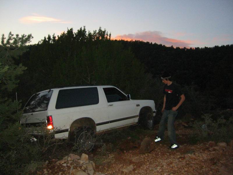
The kid and his stuck vehicle
To their credit, they did have a flashlight and bit of food, but the kid didn’t even have a jacket and his cell phone was out of minutes (what?!). He called his buddies at the cabin on Lee’s phone. The resulting conversation was so bad it was comical. It was as though his friends kept passing the phone around to each other, none aware of how serious the situation was and seemingly uncaring. They couldn’t grasp the concept that he needed a ride out of there, nor could they figure out how to even begin trying to go there. It took 15 minutes to get across a message that should have taken 60 seconds. The kid wasn’t exactly the brightest bulb in the lot, either. It was now dark so we told them we were going to find a spot to camp. We wished them luck and hoped their friends got something together to get them out of there.
We camped at a nice spot on the side of the road, chosen with flashlights. The fire was a welcome bonus. We cooked up slices of SPAM purchased from the store in Jake’s Corner. Ahh, roasted SPAM.
We left early in the morning, warming ourselves on the next steep and technical climb. Quiet light again graced the landscape making for very pleasant riding. I found the turnoff to the Tonto Natural Bridge road with the aid of my GPS. The road was rough and pretty muddy, but better than riding the highway. We pedaled over to check out the natural bridge, but the park was closed, so we wrapped it up on the highway into Payson instead. I feared my life several times on the shoulderless wonder, but it did not take too long to roll into town for a well deserved breakfast at the Beeline Cafe followed by interesting conversation from EC Shrank. EC was also our ride back to Superior — thanks EC!
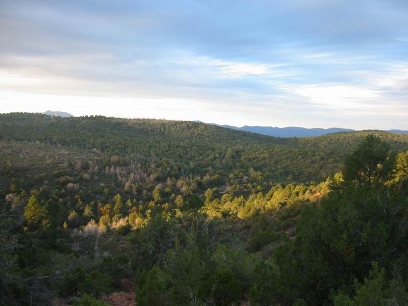
Morning light over the forest
143 miles, 17,000 feet of climbing. ~10 hours of hike-a-bike
Photos/Map: Here.

Leave a Reply