Yesterday I completed a longstanding goal of mine: Round the Mountain trail on Mt. Graham.
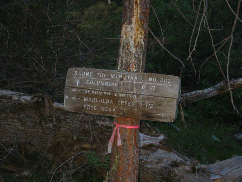
The journey began at Columbine. I coasted down a dirt road, cold at 7am and 9000 feet. A sign read “Warning, High Bear Activity Area.” The road was gated and I continued past it on “double track that rides like singletrack.”
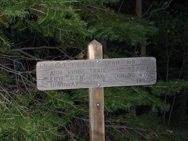
I met the Round the Mountain trail sign: 14 1/2 miles to SR 366. The first 20 feet of the trail looked enticingly good. I rolled on into the unknown.
My feet were numb and my pack weighed 30 lbs with 160oz of water and a day or two worth of food. In this state I did not fare well on the first climb. I hiked up and over the Pinnacles ridge.
This was the point of no return: A 2000 foot descent was before me. I rolled on.
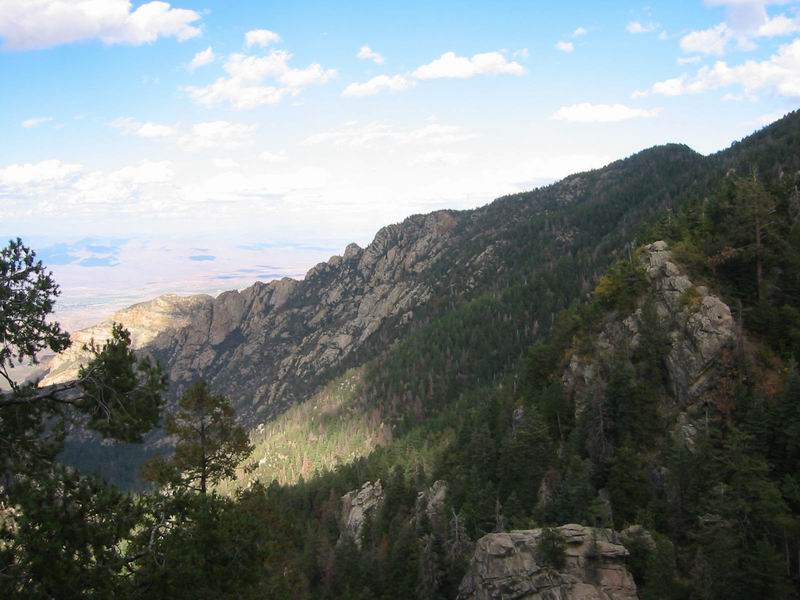
Round the Mountain drops over 4000 feet to SR 366. But before it reaches the highway it climbs out of three large canyons, picking up over 4000 feet of climbing.
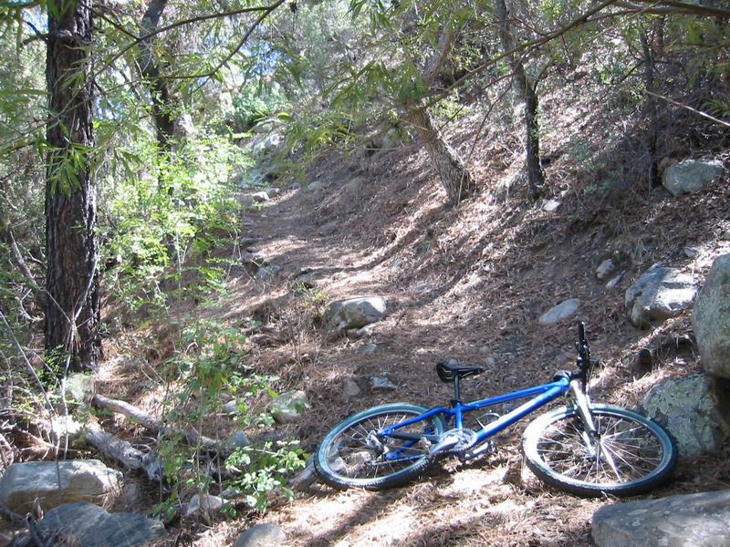
I was soon pinching myself as the first descent turned out to be deliciously rideable with soft switchbacks, rock ledges and excellent trail conditions. It was difficult enough that I dabbed frequently and walked sections I would normally ride if not in solo-expedition mode.
I neared the canyon bottom and the trail became more and more faint. It was a canyon not unlike the legendary CDO. I was lost in the woods–no trail. I picked up a faint trail that was heading down the canyon. After following/hiking it for a while I was worried it was one of the many trails leading off the mountain to Safford. A bit further I found the trail intersection. Round the Mountain #302 headed right and upwards. I hiked the initial grunt and then hopped on for the granny gear grind.
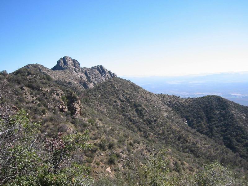
Welcome to Red Ridge. The climb was just as relentless, but fortunately not as long. I shocked myself by pulling many tight turns while riding at or near 100%. Eventually I started walking. It hurt, but I was at the top of the first climb. Things were looking brutal, but not completely ridiculous, so I rolled over the top for the second descent.
It too was tasty: endless switchbacks. But halfway down, a bad sign: the pines faded to oaks and manzanita; the trail got rocky, overgrown and impossible. After six tough switchbacks in the sun, I rounded a corner and the trees reappeared. More bacon fat ensued, and I soon reached the bottom of the second canyon, Deadman Canyon.
The second climb was more difficult and longer than the first, but I managed to ride slightly more than I walked. But it dug deep into my energy stores.
At the top I was back in Samaniego style trees–a carpet of soft pine needles. After a few impossible downhill switchbacks the trail got nice again. Inevitably, the trees faded once again and things got difficult. I was walking extended downhill sections and scared of killing myself on others.
My rear tire slowly went slime-style flat. I thought about pumping it up, but didn’t want to waste the energy (I knew it would just go flat sometime in the next 5 hours, anyway). So I changed it, pulling out an inch long thorn, and continued on. Five minutes later my spare went flat, this time quickly (non-slime). I pulled out another one inch thorn. I didn’t know where they were coming from–I wasn’t visibly running over anything.
At this point I praised my luck in flatting last week on the rivertrail. It was because of those series of flats that I discovered my patch glue had dried up & replaced it with a fresh one. So I was able to patch both of my tubes–but I had a lone patch remaining after this.
10 minutes of scattered riding later my rear went flat again. My thoughts turned to walking 7 miles and hitch-hiking back up the highway. I pulled yet another inch long thorn from my tire and scanned 50 yards of the trail for the source of my woes. Nothing to be found.
Determined to avoid cacti and overgrowth at all costs, I rolled on. I knew this was impossible because the trail was horribly overgrown, but it made me feel better to pretend I was being careful. I passed Round the Mountain spring, a trickle and some pools, that runs year round. There I promptly lost the trail and began searching. I picked up a few game trails (it seems the spring is heavily used) but had a hard time figuring out which trail was Round the Mountain.
It took a long time to reach the bottom of Marijilda canyon. There were a few minor climbs, which were only relatively minor: still 300 feet and only 40% rideable.
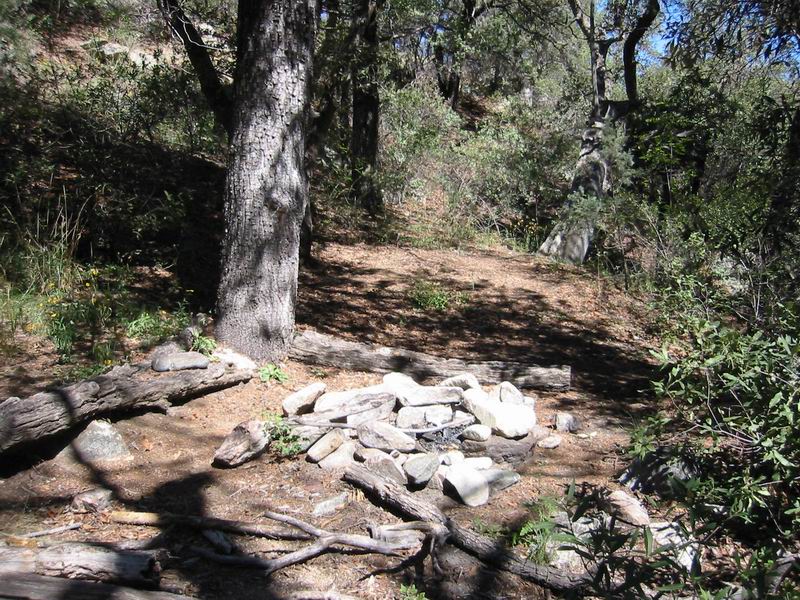
At Marijilda it was again CDO like and there was a nice campsite. The brutality factor only increased from here as the final climb was a death march. It lacked shade, was rocky and gained over 1000 feet in 1.2 miles. Looking at the GPS track I count no less than 27 switchbacks. I rode a few and then began practicing the most efficient way to ride to a turn, unclip, flip my bike around and try to continue riding. I was walking and hurting. As I neared the top the trail got dangerous–exposure and very narrow, sloughed tread.
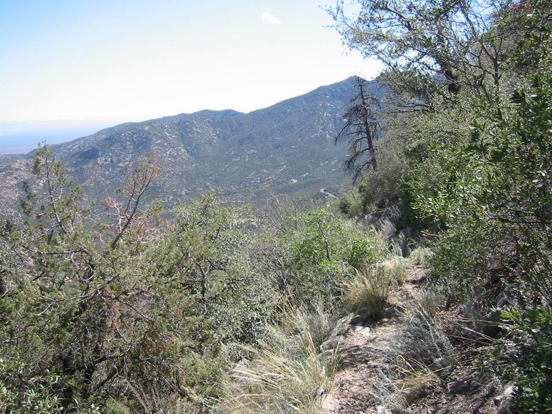
At the top I beheld the glorious sight of pavement. But it was 1200 feet below me. Fortunately the trail from here was slightly more reasonable, but still very difficult. It was the same style as the bottom of the Lady Bug trail, where, three months ago I earned 22 stitches on my cheek from a crash. I understandably took it easy.
I reached the bottom of a creekbed and knew I was done with the trail. I sat down, relieved.
After eating I climbed out of the creek and into the trailhead parking lot. Exclamations of “woo hoo” and a raised fist were offered. I had accomplished my goal and survived the trail. I thanked the mountain and the trail for the unbelievable challenge.
Now all that remained was to ‘simply’ climb back to the top of the mountain. I had only been worried about surviving the trail, never giving a thought to the monster of a ride that awaited me at the end of the trail. It was an afterthought.
Five and a half hours and twenty miles into the ride I sat ready to climb 6000 (total) feet back to the top. I rode on the pure adrenaline of completing the trail for the first half hour. It was altogether too fast and my head danced on fire with a million thoughts. My upper body began to fatigue and I wasn’t breathing normally.
I stopped in at Arcadia to regain myself. At 6700′ I propped myself against a stone wall and sat. Through the sounds of Dream Theater on my mp3 player I heard a loud voice. Did someone have their radio blasting in a campground? I took off my headphones and confirmed the voice. Not ten seconds later I realized what I was listening too: LDS General Conference. I could not understand the voice, nor could I make out the speaker, but from the pausing and general style I knew what it was. The hours of listening to this style as a youth trained my ears well. I reviewed in my mind if today could possibly be conference, but it was only an exercise: I knew what I was hearing. Yes, today was conference. How inconsiderate of this family to blast a radio this loud at a campground where people go to escape the noise of the city. I ate two or three GU’s and reluctantly pulled out of the campground. I saw a few heads follow me, interested in if I was turning up or down the mountain. I turned up.
As the elevation ticked higher on my GPS I depleted my energy stores. The climb was twice as hard as I imagined it. I struggled to keep my speed around 8mph and thought about Drew Miller averaging 14mph on his record breaking ascent last weekend. I was deep in the pain cave, as they say.
I wondered what the heck I was doing. I thought about resorting to the windswept thumb. I worried about Paula, back at the top, worried about me. I doubted my ability to continue on. I wondered how I had pushed through this kind of pain before, during Lotoja, Cream Puff 100, Brian Head, Red Ridge, etc. I wondered if I had pushed through this kind of pain before. I wasn’t sure. I wasn’t sure of anything except that I needed to get back.
How I was “feeling” at any given time was an impossible mixture of variables. It can’t be quantified. My legs would go in and out of strength, my shoulders would weaken, then release, my stomach would ache then hunger. I would be hot and cold, comfortable on the bike, or not. I was forced to put these varieties aside and focus on the goal, the aim. It was my only choice.
Suddenly, I found it. I found that place inside, that darkness. Focused on a single aim, shunning everything else. The aim was real, everything else illusion. The extreme pain and suffering were staved off, inconsequential. With everything else gone what remained had to be real.
This is not a proper description, but I do not know that one exists. For a time I rode inside myself. It was incredible, but I was not there for long. Before I reached the last, brutal 900 foot dirt road climb to 9600′ I was back in the pain cave, dying. As I rounded the corner for the descent to Ash Creek campground I got a beep from Paula’s radio. 1.5 miles from home, I coasted free at last.
Numbers:
| 9 | Number of hours |
| 9000 | Vertical gain (feet) |
| 40 | Miles traveled |
| Innumerable | Number of dabs/hikes |
| 3 | Number of flats |
| 1 | Number of patches left after 3rd flat |
| 8 | Number of GU’s consumed |
| 100+ | Number of switchbacks |
| Confirmed | Status of reservation in Hoytsville |
Here is the map, photo placement and stats.
Even shuttling this ride would be an exercise in brutality. The climbs are too steep and there is too much hiking involved. People talk about certain rides being only for the crazy, but my saying this trail is only for the crazy comes from a guy who thinks climbing Red Ridge and the CDO west fork is fun. I am the sort of retard who rides Milagrosa backwards, then Molino, just for added challenge. Just look at the numbers: 5.5 hours for 14.4 miles. That’s an average speed of less than 3 mph and start to finish the trail drops 4000 feet! I could hike this trail, with a pack, faster. My bike was no advantage, instead it added challenge, difficulty and an awkward weight to lug up switchbacks and get caught in branches.
I had no idea what the trail would be like and had never heard of anyone attempting it. But from the first moment I found it on a topo map years ago, I knew I had to ride it. At any cost.
The danger factor was high–mostly due to the remoteness, unknown trail and the fact that I was riding solo. It nearly turned into a real epic with flats for a while there. I admit that after seeing the high bear activity sign followed by bear scat and big prints in the pine needles, I was a bit scared.
But the fearful fall foul of fate just as often as the reckless. I wouldn’t consider myself reckless, but this is a major part of what wilderness is all about: the risk, the danger and the challenge. I went well outside of my comfort zone on this ride.
It was also good because of the suffering. The Soul Ride will seem like a piece of cake in comparison. And, for the first time since my knee problems began about a year again, I did not want to ride anymore. My thirst had been quenched, at least for one day.

Leave a Reply