Route Description
The AZT bike route is not intended as a general loaded touring route. To ride the Arizona Trail with a Bob Trailer or full camping gear, it is highly recommended that you stick with the route described by Andrea Lankford in her book. She stayed off the established trail for a reason. Even on an unloaded bike the AZT is a very difficult to ride--difficult enough that many portions of the AZT, though open to bikes, are rarely ridden and regarded as deathmarch hike-a-bike-fests. It is for this reason that we've worked hard to minimize our gear such that hike-a-bike and technical riding is feasible.
What it means to us
Our goal is to ride as much of the AZT as is open to bikes. This does not mean, however, that we will ride out and back to a wilderness boundary just to pick up sections of "open trail." There are also sections where the trail dives in and out of wilderness, so those sections would be impossible to ride without traveling through wilderness. The idea is that our route is exactly that -- a route. It won't go travel out and back (though we will, to towns).
There are also some setions of open "trail" that we will not ride. For example, near Roosevelt Lake, you could climb 1800 feet on a dirt road (signed as official AZT), then descend a different dirt road right back to the pavement (official AZT continues into the Mazatals). The distance you cover by taking this ~2 hour detour? 2 miles of flat pavement. A truly hard core AZT route would make that climb. If we're completely out of our minds, we might, but there isn't even any singletrack to be had by it. We will, in the course of taking our bike detours, make some decisions that are not the fastest way back to the trail but instead take us to prime rideable AZT stretches. One example of this is by Redington Pass.
Our route, if completed, might be the most 'true' to the trail to date. One reason to not make the so-called 'ridiculous' detours is to leave room for someone to one-up us. Sounds good to me! There are also several stretches of unbuilt trail which, surprisingly, we won't be riding (though in a some cases we will be bushwacking them).
We also view mountain biking and wilderness travel as a self-sufficient endeavor. We don't have a support vehicle, and like it that way. The kindness of strangers is always appreciated, though.
Gunsight Gap
This is one unique bike route we pioneered for bypassing the Superstition Wilderness. It's a rugged and difficult one, and one that has rarely been attempted since. Nonetheless it is documented and available here.
AZTMBR Profile (approximate)
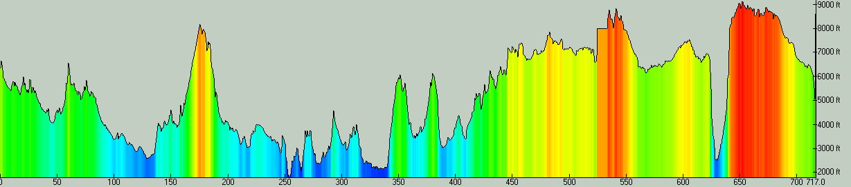
717 miles is an underestimate on the total distance. The track used for the above profile contains some collected GPS data but a great deal of hand drawn, simplified routes as well. The total elevation gain for the above GPS track is 100,000 feet, but it is likely more than that. The only section that is missing data is from Flagstaff to Schultz Pass.
Contact
Scott can be reached at smorris@topofusion.com.